Graphcast: A Breakthrough AI Model for Highly Accurate and Efficient Global Weather Forecasting

Weather forecasting is one of the most complex and important scientific challenges facing humanity today. Accurate predictions of weather conditions days in advance can help save lives, optimize industries, and inform critical decision making. However, traditional numerical weather prediction (NWP) approaches rely on complex physics-based simulations that require immense computing power and deep expertise to develop and run.
Now, a groundbreaking new AI model called Graphcast, developed by researchers at Google, is poised to revolutionize global weather forecasting. By leveraging advanced machine learning techniques and decades of historical weather data, Graphcast can generate highly accurate 10-day global forecasts with unprecedented computational efficiency. A paper published in the journal Science details how Graphcast outperforms the current industry gold-standard weather simulation in accuracy while requiring orders of magnitude less computing power and time.
How Graphcast Works

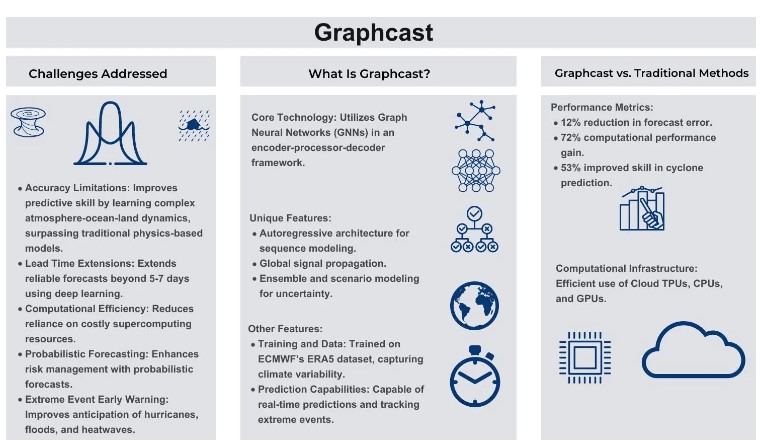
At its core, Graphcast is a deep learning model based on graph neural networks (GNNs), an architecture well-suited for processing the spatially structured data of global weather systems. The model was trained on over 40 years of historical weather data from the ERA5 reanalysis dataset compiled by the European Centre for Medium-Range Weather Forecasts (ECMWF). This dataset combines historical observations from satellites, radar, weather stations and other sources with NWP techniques to reconstruct a comprehensive record of past global weather conditions.
From this vast trove of training data, Graphcast learned the complex web of cause-and-effect relationships governing the evolution of weather systems over time. The resulting model can ingest just the weather conditions at the present time and 6 hours prior, and roll forward highly accurate predictions in 6-hour increments out to 10 days in the future.
Graphcast makes predictions at a high spatial resolution of 28km x 28km grids spanning the entire globe – over 1 million data points. At each grid point, it forecasts five key surface variables like temperature and wind speed, as well as six atmospheric variables at 37 different altitudes. Despite this level of detail and complexity, Graphcast can generate a full 10-day global forecast in under 1 minute using a single TPU v4 machine. In contrast, the ECMWF’s HRES model, widely considered the best in the world, requires hours of computation from a supercomputer with hundreds of nodes to produce a forecast of similar length.
Unprecedented Accuracy When evaluated against the HRES model in comprehensive tests, Graphcast delivered more accurate predictions for over 90% of the 1380 weather variables and forecast timespans analyzed. Focusing on just the troposphere, the critical 6-20km band of atmosphere closest to the Earth’s surface, Graphcast beat HRES for 99.7% of variables tested.
This leap in predictive accuracy can have profound real-world impacts. In one striking example, Graphcast locked onto an accurate forecast track for Hurricane Lee’s Nova Scotia landfall a full 9 days in advance during a live trial in September 2022. HRES predictions vacillated until converging on the correct track only 6 days out. Earlier and more accurate hurricane path forecasts enabled by Graphcast could give affected populations more time to prepare and evacuate.
Graphcast also shows promise in predicting other extreme weather events beyond what it was specifically trained for. By applying a cyclone tracking algorithm to its outputs, researchers found Graphcast maintained higher accuracy than HRES in projecting cyclone paths as the forecast window lengthened. The model can characterize atmospheric rivers to help predict flood risks, and it can flag upcoming heat waves sooner by identifying when temperatures will exceed historical maximums for a given time and place.

Efficiency and Accessibility Perhaps just as significant as Graphcast’s accuracy gains is the dramatic reduction in computational cost and complexity it demonstrates compared to physics-based simulations. The ability to produce world-class forecasts on a single machine in under a minute opens up new possibilities for making weather prediction more accessible and useful for a wider range of applications.
To accelerate this progress, the Graphcast model code has been open-sourced, enabling researchers and forecasters worldwide to experiment with and build upon it. ECMWF is already running a live trial of Graphcast forecasts. The code could be adapted to focus on specific weather phenomena or optimized for regional prediction needs.
Graphcast joins other cutting-edge weather models developed by Google researchers, including a nowcasting system for short-term forecasts and MetNet-3 for improved 24-hour regional predictions already deployed across the U.S. and Europe. Together, these AI-powered tools promise to democratize access to faster, more accurate, and more useful weather forecasts for billions worldwide.
Looking Ahead As climate change continues to disrupt historical weather patterns, adaptable AI prediction systems like Graphcast will become increasingly vital. The model will continue to evolve and improve as more and higher-quality weather observations become available to train it.
Beyond its practical utility for weather forecasting, Graphcast demonstrates the immense potential for AI and machine learning to help us better understand and predict the workings of complex natural systems. With further research and development, these technologies could become integral for climate modeling, ecological monitoring, disaster response, and more.
By enabling us to anticipate future conditions with greater foresight and confidence, AI-powered predictive tools like Graphcast can empower scientists, policymakers, and society at large to make better decisions in the face of growing environmental risks and challenges. While we may not be able to control the weather, breakthroughs like Graphcast bring us one step closer to being able to plan for whatever it may bring.
