The Midwest Derecho: An Unforgettable Tempest’s Trail of Wind Destruction (August 10, 2020)
The date August 10, 2020, is etched in the memories of millions across the Midwest, a day when the skies unleashed a tempest of unimaginable fury. A derecho, a powerful and expansive windstorm, ripped through the heartland, leaving a trail of devastation that stretched from South Dakota to Ohio. This wasn’t just a storm; it was a meteorological monster, its ferocity exceeding expectations and its impact leaving communities reeling in its wake.
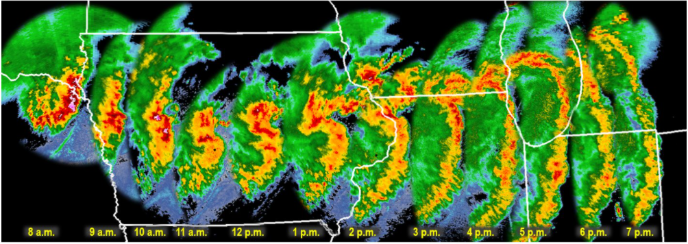
The storm’s genesis lay in the atmospheric instability brewing over South Dakota and Nebraska. Thunderstorms erupted, fueled by a potent mix of warm, moist air and strong upper-level winds. These storms, initially isolated, began to coalesce into a line, forming a squall line, a telltale sign of a developing derecho. This line of storms, propelled by the jet stream, raced eastward at speeds exceeding 70 mph, evolving into a meteorological juggernaut.
Iowa found itself directly in the derecho’s path, bearing the brunt of its wrath. Wind gusts of up to 140 mph, equivalent to a Category 4 hurricane, tore through cities and towns. Cedar Rapids, a city of over 130,000, was particularly devastated. The winds, relentless and unforgiving, peeled roofs off buildings, tossed vehicles like rag dolls, and uprooted centuries-old trees. The city’s landscape was transformed into a scene of utter chaos, with debris littering the streets and power lines dangling precariously.
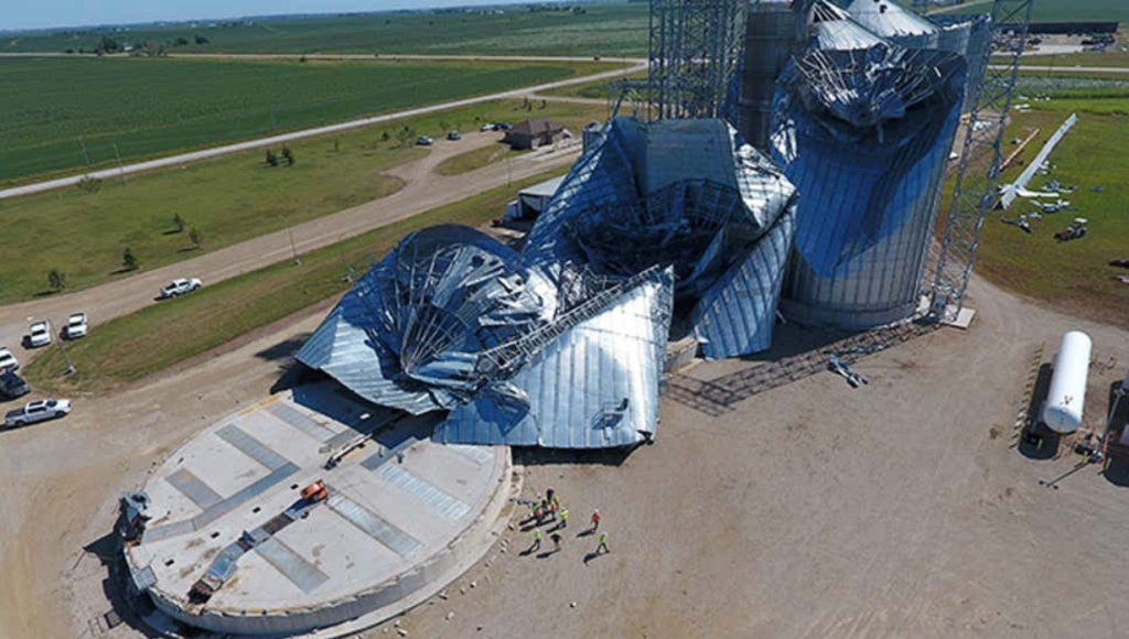
The derecho’s impact extended far beyond Cedar Rapids. Across Iowa, an estimated 14 million acres of cropland were damaged or destroyed, representing roughly a third of the state’s corn and soybean crops. The agricultural industry, the backbone of Iowa’s economy, suffered a staggering blow, with losses estimated in the billions of dollars. The storm’s fury also left millions without power, plunging homes and businesses into darkness and disrupting daily life for weeks.
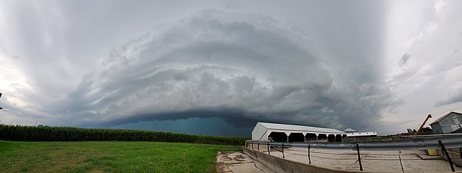
In Cedar Rapids, Iowa, the derecho’s arrival was swift and brutal. At approximately 11:15 am, the sky turned an ominous green as the leading edge of the storm approached. Within minutes, the city was engulfed in a maelstrom of wind and rain. Residents huddled in basements and interior rooms as the deafening roar of the wind filled the air. Trees snapped like twigs, roofs were peeled off buildings, and debris flew through the air like missiles. One resident recounted the terrifying experience of watching a large tree crash through his living room window, narrowly missing him and his family.
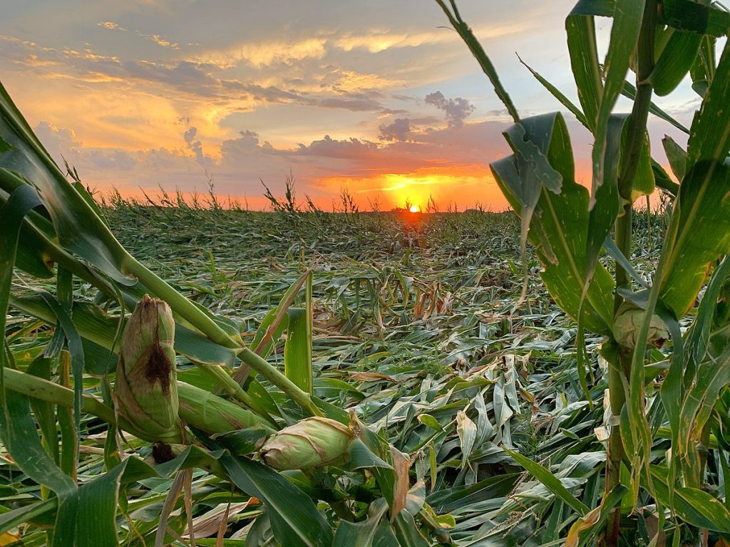
The storm’s impact on rural communities was equally devastating. Farmers watched in disbelief as their corn and soybean fields, once lush and green, were flattened in a matter of minutes. Grain bins were crumpled like soda cans, and barns and outbuildings were reduced to piles of debris. One farmer, who had worked the land for over 50 years, described the scene as “total devastation,” his livelihood wiped away in an instant. The derecho’s impact on agriculture reverberated throughout the region, disrupting supply chains and causing food prices to rise.
As the derecho continued its eastward rampage, it maintained its intensity, leaving its mark on Illinois, Indiana, and Ohio. Chicago experienced wind gusts exceeding 90 mph, causing widespread power outages and bringing the city’s bustling transportation system to a standstill. In Indiana, the storm spawned several tornadoes, adding to the destruction. Even as the derecho weakened, it continued to produce damaging winds and heavy rain, extending its reach over 770 miles and impacting millions.
The meteorological intricacies that birthed and sustained this derecho were complex. A key factor was the presence of a strong upper-level jet stream, which provided the necessary wind shear to organize the thunderstorms into a line and propel them forward at breakneck speeds. Additionally, a pre-existing mesoscale convective system (MCS), a large cluster of thunderstorms, served as the derecho’s building block, providing a source of lift and moisture.
As the derecho matured, it developed a bow echo, a characteristic radar signature associated with destructive straight-line winds. The bow echo, shaped like an archer’s bow, indicated the presence of a powerful downdraft, which spread out upon reaching the ground, generating the hurricane-force winds that ravaged the Midwest. The combination of these factors created a perfect storm, a derecho of unprecedented power and scope.
Derechos have a long and destructive history in the United States, with several notable events leaving their mark on the nation’s memory. One of the most infamous derechos occurred on June 29, 2012, sweeping across the Mid-Atlantic region and causing widespread damage from Indiana to the East Coast. This derecho, known as the “Super Derecho” due to its exceptional intensity and scope, produced wind gusts exceeding 100 mph and left millions without power. The 2012 derecho traveled over 700 miles and caused an estimated $2.9 billion in damage, highlighting the destructive potential of these powerful windstorms.
Another significant derecho event occurred on May 8, 1995, impacting a large portion of the Midwest. This derecho, which originated in Kansas, traveled over 1,000 miles and produced wind gusts of up to 120 mph. The storm caused widespread damage to trees, power lines, and structures, leaving over 2 million people without power. The 1995 derecho was particularly notable for its long duration, lasting for over 12 hours, and its extensive path, which stretched from Kansas to the East Coast.
The Midwest derecho of 2020 stands out for several reasons. Its peak wind gusts of 140 mph were among the highest ever recorded for a derecho, rivaling the intensity of a major hurricane. The storm’s impact on agriculture was particularly severe, with millions of acres of crops damaged or destroyed, causing significant economic losses. Additionally, the derecho’s rapid intensification and relatively short warning time caught many off guard, underscoring the challenges of forecasting and preparing for these powerful windstorms. While derechos are not uncommon in the Midwest, the 2020 event served as a stark reminder of their destructive potential and the importance of remaining vigilant during severe weather events.
The Midwest derecho of 2020 stands as a stark reminder of the unpredictable and destructive nature of severe weather. Its impact extended far beyond the immediate damage to infrastructure and agriculture, leaving a lasting mark on the lives of millions. The storm exposed vulnerabilities in infrastructure and emergency response systems, prompting a reevaluation of preparedness measures and a call for increased investment in resilient infrastructure. As communities rebuild and recover, the memory of the derecho serves as a powerful motivator to strengthen defenses against future storms and ensure the safety and well-being of those who call the Midwest home.