The Ultimate Guide to Becoming a Storm Chaser
Storm chasing demands more than just a sense of adventure; it requires a solid foundation in meteorology. This section equips aspiring chasers with the essential knowledge to understand the weather phenomena they’ll encounter.
Demystifying the Atmosphere:
- Atmospheric Layers: Our atmosphere isn’t a uniform blanket; it’s layered. The troposphere, closest to the Earth, is where most weather happens due to its temperature and pressure variations. Above it lies the stratosphere, home to the ozone layer, and beyond that, further layers with decreasing air density. Understanding these layers helps grasp how weather systems form and move.
- Atmospheric Pressure: Air pressure, the weight of the air above us, is a key weather driver. High-pressure systems generally bring fair weather, while low-pressure systems often lead to clouds and precipitation. The interaction between these systems generates wind, and their movement dictates weather patterns.
- Temperature and Moisture: These two factors are critical for storm formation. Warm, moist air is less dense and tends to rise, creating instability. As it rises, it cools and condenses, forming clouds and potentially precipitation. The amount of moisture in the air, known as humidity, influences how much energy is available for storms to develop.
Decoding Thunderstorms:
- Thunderstorm Recipe: Thunderstorms need four key ingredients: instability (warm, moist air near the surface and cooler air aloft), lift (a mechanism to force air upwards), moisture (fuel for cloud and rain formation), and wind shear (changing wind speed and direction with height, which helps storms organize and sustain themselves).
- Thunderstorm Varieties: Not all thunderstorms are created equal. Single-cell storms are brief and isolated, while multi-cell storms are clusters of cells that can produce heavy rain, hail, and strong winds. Supercells, the most intense type, have a rotating updraft and can spawn tornadoes, large hail, and damaging winds.
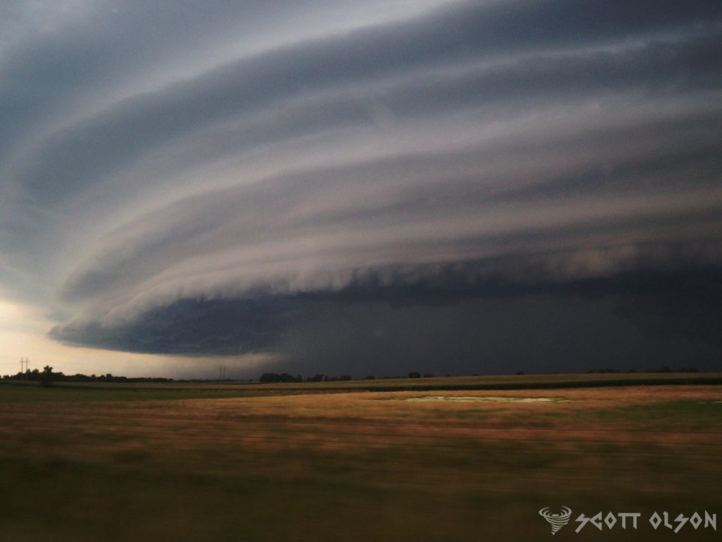
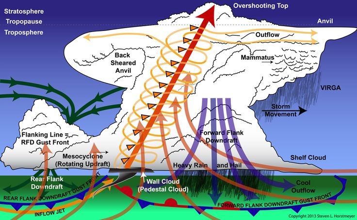
- Thunderstorm Anatomy: Visualize a thunderstorm as a towering engine. The updraft is the rising column of warm, moist air that fuels the storm. The downdraft is the cool air and precipitation descending from the storm. The anvil cloud is the flat, spreading top of the storm, and the flanking line is a line of developing cells feeding into the main updraft. Recognizing these features helps assess a storm’s stage and potential severity.
Tornado Genesis:
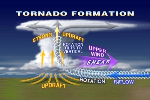
- Supercells and Tornadoes: While not all supercells produce tornadoes, most significant tornadoes come from them. Look for a rotating wall cloud, a lowered area of the storm base with persistent rotation, as a sign that a tornado might form.
- Tornado Life Cycle: A tornado starts as a funnel cloud extending from the storm base. As it reaches the ground, it becomes a tornado. The mature stage is when the tornado is at its strongest, and it eventually dissipates as the storm weakens or the updraft loses its rotation.
- Tornado Intensity Scale: The Enhanced Fujita (EF) scale rates tornadoes from EF0 (weakest) to EF5 (strongest) based on the damage they cause. Understanding this scale helps assess the potential danger and provides a common language for describing tornado intensity.
Tools of the Trade:
- Weather Radar and Satellite Imagery: Radar shows precipitation intensity, storm structure, and rotation, while satellite imagery provides a broader view of cloud patterns and storm systems. Look for hook echoes on radar, a telltale sign of a rotating mesocyclone, and towering cumulonimbus clouds on satellite images, indicating strong updrafts and potential severe weather.
- Surface Observations and Weather Maps: Analyze surface observations to identify areas of converging winds, temperature and dew point spreads, and pressure falls, all of which can signal storm development. Weather maps depicting fronts, pressure systems, and wind patterns help predict where storms are likely to form and track.
- Storm Spotter Reports: Trained storm spotters provide real-time ground truth of hail size, wind damage, and tornado sightings. These reports are invaluable for confirming radar-indicated threats and providing situational awareness during a chase.
With a foundational understanding of meteorology, you’re ready to delve into the practical aspects of storm chasing. This section will guide you through the steps involved in planning and executing a safe and successful storm chase.
Preparation is Key:
- Target Selection: Based on the meteorological factors discussed in Section 1, identify a target area with a high probability of severe weather development. Utilize forecasting tools such as weather models, radar imagery, and surface observations to pinpoint potential hotspots for thunderstorm and tornado formation.
- Route Planning: Plan your route carefully, considering road networks, potential escape routes, and areas with good visibility of the sky. Be aware of potential hazards such as low-lying areas prone to flooding, and avoid chasing in urban areas where visibility and maneuverability are limited.
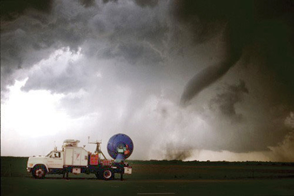
- Vehicle and Equipment: Ensure your vehicle is reliable and in good condition, with a full tank of gas. Essential equipment includes a GPS navigation system, a laptop or tablet with internet access for real-time weather data, a two-way radio for communication, and a camera for documentation.
- Safety First: Chasing storms inherently involves risks. Always prioritize your safety and the safety of others. Have a plan for seeking shelter in case of a tornado warning, and be aware of lightning dangers. Never attempt to outrun a tornado or drive through flooded roadways.
The Chase is On:
- Positioning: Once you’ve reached your target area, position yourself for optimal viewing and intercept of the developing storms. Look for visual cues such as towering cumulonimbus clouds, rotating wall clouds, and inflow bands (lines of clouds feeding into the storm).
- Visual Observations: While radar and other technological tools are valuable, visual observations remain crucial. Pay attention to the storm’s structure, movement, and any signs of rotation or tornado development.
- Communication and Collaboration: Maintain communication with other chasers or spotters in the area to share information and coordinate observations. Collaboration enhances situational awareness and helps ensure safety during the chase.
- Documentation: If conditions allow, document the storm’s evolution through photos and videos. This documentation serves as a valuable record of the event and can contribute to scientific research and understanding of severe weather.
Ethics and Responsibility:
- Respect Private Property: Always seek permission before entering private property. Avoid blocking roadways or interfering with emergency responders.
- Minimize Environmental Impact: Leave no trace of your presence. Dispose of waste properly and avoid disturbing wildlife or vegetation.
- Responsible Reporting: If you witness a tornado or other severe weather event, report it to the National Weather Service or local authorities to ensure timely warnings are issued.
Staying ahead of the storm requires access to reliable weather data and forecasting tools. Here’s a list of websites and apps that will empower your storm chasing endeavors:
Government and Official Sources:
- National Weather Service (weather.gov): The cornerstone of weather information, the NWS provides forecasts, warnings, and radar data for the entire United States. Check local forecasts, severe weather outlooks, and real-time radar imagery to stay informed about potential threats.
- Storm Prediction Center (spc.noaa.gov): The SPC is your go-to source for convective outlooks, mesoscale discussions, and watches for severe thunderstorms and tornadoes. These resources offer valuable insights into the potential for severe weather and the areas at highest risk.
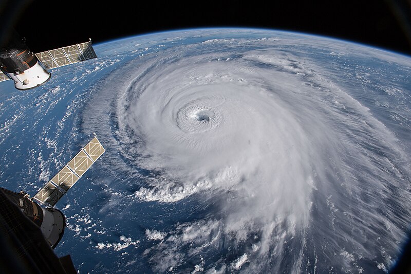
- National Hurricane Center (nhc.noaa.gov): For those chasing tropical cyclones, the NHC is indispensable. Get the latest hurricane forecasts, tracks, and potential impacts, ensuring you’re well-prepared during hurricane season.
Radar and Satellite Imagery:

- College of DuPage NEXLAB (weather.cod.edu): NEXLAB grants access to real-time and archived weather radar data, including super-resolution imagery and storm-tracking tools. Dive deeper into storm structure and evolution with this comprehensive resource.
- RadarScope (radarscope.com): A favorite among chasers, RadarScope provides real-time radar data with advanced features. Track storm cells, analyze velocity data, and utilize hail detection algorithms to gain a comprehensive understanding of storm dynamics.
Weather Models and Forecasting Tools:
- Pivotal Weather (pivotalweather.com): Access a suite of weather models, including the GFS and NAM, along with analysis tools and forecast discussions. Pivotal Weather helps you understand the broader atmospheric patterns influencing storm development.
- WeatherBell Analytics (weatherbell.com): Explore a variety of weather models, forecast maps, and analysis tools, with premium options for more in-depth forecasts. WeatherBell provides insights into the synoptic-scale setup conducive to severe weather.
Mobile Apps:
- Predict Now (iOS): The ultimate app for serious weather enthusiasts and chasers. Predict Now provides access to:
- High-resolution radar data
- NSSL WRF and HRRR weather models
- GOES-16 satellite imagery
- Mesoanalysis tools
- NCEP surface fronts and analysis
- NAM 3km model data
- SPC outlooks and mesoanalysis
- Surface observations
- Forecast soundings
Community and Educational Resources:
- Stormtrack Website and Forum (stormtrack.org): Access a wealth of information, discussions, and forecasts from experienced chasers and meteorologists. The Stormtrack forum is a valuable platform for learning and sharing knowledge about severe weather.
- Facebook Groups: Numerous Facebook groups dedicated to storm chasing and weather offer opportunities to connect with other enthusiasts, share observations, and learn from the experiences of others.
Additional Resources:
- Spotter Network (spotternetwork.org): This platform allows you to share and access real-time storm reports from trained spotters, providing valuable ground truth information during a chase.