Greensburg, Kansas: When the Sky Fell – May 4th, 2007
The small town of Greensburg, Kansas, nestled amidst the vast plains, exuded a sense of timeless tranquility. Its residents went about their lives, their days marked by the rhythm of the seasons and the gentle sway of the prairie winds. Little did they know that on May 4th, 2007, the sky itself would become an instrument of destruction, forever altering the landscape and etching a story of resilience into the heart of the community.
As the afternoon sun cast long shadows across the fields, a monstrous supercell thunderstorm developed to the northwest of Greensburg. Unbeknownst to the town’s residents, this storm harbored a dark secret within its swirling mass: a violent EF5 tornado, the most powerful category on the Enhanced Fujita scale.
Around 9:45 PM, the tornado, a swirling vortex of devastation with winds exceeding 205 mph, descended upon Greensburg. It tore through the town with unrelenting fury, leaving a path of destruction a mile and a half wide and nearly 22 miles long. Homes were obliterated, businesses reduced to rubble, and landmarks that had stood for generations were swept away as if they were mere toys in the wind’s grasp. The darkness of the night was illuminated by the eerie green glow of power flashes and the surreal dance of debris swirling in the air.
When the winds finally subsided and the dust settled, the town of Greensburg lay in ruins. 95% of the town’s structures were destroyed or severely damaged. The landscape was unrecognizable, a scene of utter devastation that resembled a war zone more than a peaceful Midwestern town. Tragically, eleven lives were lost that night, and countless others were injured.
The atmospheric setup on May 4th was extremely favorable for severe thunderstorms and tornadoes over the central Plains. A powerful jet stream was digging southeast into the region, providing strong wind shear and upward motion. At the same time, a warm, moist airmass was surging north at the surface. This created an environment with abundant instability – in other words, the fuel needed for explosive thunderstorm development.
By early evening, the first thunderstorms began erupting along a dryline in western Kansas. One particular cell quickly became dominant and took on supercell characteristics as it moved northeast. Storm chasers reported a “left-split” appearance to the storm early on, indicating a powerful updraft.
As the supercell approached Greensburg around 9:00 pm CDT, it was a monster. The storm had an extremely unstable airmass to work with, with CAPE values estimated over 5000 J/kg – an extraordinary amount of available energy. It also had incredible wind shear, especially at low levels, allowing it to maintain its intense rotation.
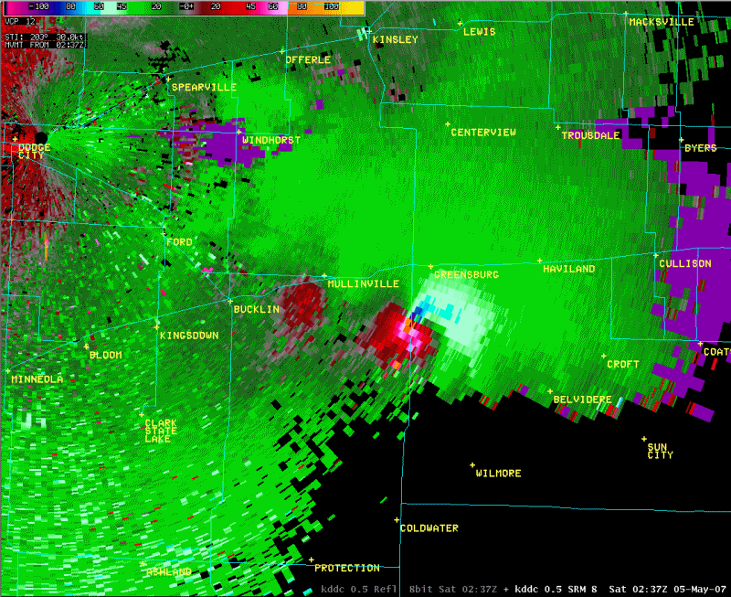
Radar imagery from the Dodge City, Kansas WSR-88D radar (KDDC) showed a classic supercell structure, with a hook echo and bounded weak echo region (BWER) evident. But what was especially remarkable were the Doppler velocity signatures. The tornado cyclone (TC) signature associated with the developing Greensburg tornado was sampled by KDDC to be 2-4 km wide, with gate-to-gate velocity differences of 100-130 knots at times. This is an incredibly intense circulation, on par with the strongest ever measured.
As the tornado struck Greensburg around 9:45 pm, it was at peak intensity. Damage surveys indicate the tornado was at least 1.7 miles wide at this point, with winds estimated at 205 mph. The tornado was so strong that it scoured the ground and erased the town of Greensburg in a matter of minutes. Miraculously, advance warning and sturdy shelters limited the death toll to 11.
In the aftermath, meteorologists pieced together the evolution of this remarkable storm. Unique features were identified in the radar data, including a “vortex hole” – a column of weak reflectivity coincident with the intense tornado cyclone. This may have represented centrifuging of precipitation particles and debris out of the tornado core.
As the supercell thunderstorm grew, it encountered strong wind shear, a change in wind speed and direction with height. This wind shear caused the updraft within the storm to rotate, forming a mesocyclone, the rotating heart of the storm and the birthplace of tornadoes. The mesocyclone tightened and intensified, eventually giving birth to the EF5 monster that would leave its mark on Greensburg.
The Greensburg tornado stands as a stark reminder of the destructive power of nature and the importance of respecting severe weather warnings. In the aftermath of the disaster, the people of Greensburg demonstrated remarkable resilience and a spirit of community that transcended the devastation. They rebuilt their town, incorporating sustainable building practices and a renewed commitment to community, transforming tragedy into an opportunity for a brighter future. The story of Greensburg serves as a testament to the human spirit’s ability to endure and rebuild, even in the face of unimaginable loss.