The Sun, our closest star, is a dynamic and turbulent celestial body exhibiting a variety of fascinating and powerful phenomena. Among these are plasma tornadoes, also known as solar tornadoes, which are massive, swirling structures of hot, magnetized plasma that occur in the Sun’s atmosphere. These plasma tornadoes, while visually reminiscent of tornadoes on Earth, operate on a vastly different scale and are driven by the Sun’s magnetic forces. This article explores the nature, formation, and significance of plasma tornadoes on the Sun.
What Are Plasma Tornadoes?
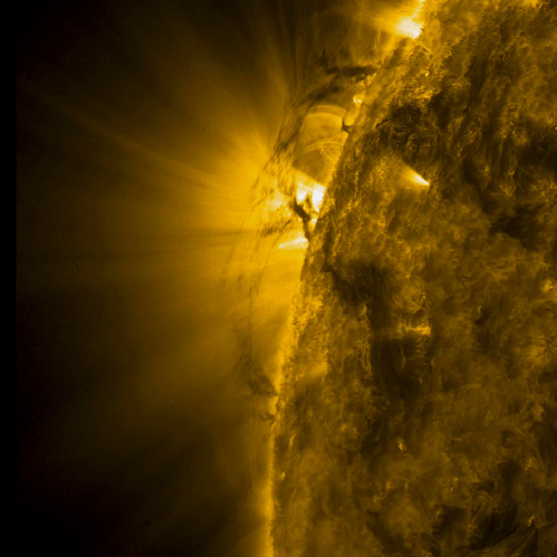
Plasma tornadoes on the Sun are towering structures that can span thousands of kilometers in height. They are formed by the intricate interplay of magnetic fields and solar plasma—an electrically charged gas consisting of ions and electrons. These solar vortices are visible in the Sun’s corona, the outermost part of its atmosphere, where they appear as spiraling columns of plasma.
Formation of Plasma Tornadoes
The formation of plasma tornadoes is closely linked to the Sun’s magnetic activity. Here’s a step-by-step look at how these phenomena form:
Magnetic Field Lines and Plasma Movement
Magnetic Field Interaction: The Sun’s magnetic field is highly complex and dynamic, with magnetic field lines constantly twisting, breaking, and reconnecting due to the Sun’s differential rotation and convective motions beneath the surface.
Plasma Convection: The solar plasma is in constant motion due to the convection currents within the Sun. Hot plasma rises to the surface, cools, and then sinks back down, creating convective cells.
Twisting Magnetic Fields: When magnetic field lines become twisted and tangled due to these convective motions, they can form helical structures. Plasma trapped within these twisted magnetic fields begins to spiral, creating the appearance of a tornado.
Magnetic Reconnection: Magnetic reconnection, a process where magnetic field lines break and reconnect, can release enormous amounts of energy, contributing to the acceleration and heating of the plasma within the tornado.
Observing Plasma Tornadoes
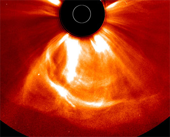
Solar telescopes and spacecraft equipped with specialized instruments, such as the Solar Dynamics Observatory (SDO) and the Solar and Heliospheric Observatory (SOHO), have provided stunning images and data on plasma tornadoes. These observations are typically made in the extreme ultraviolet (EUV) and X-ray wavelengths, which are ideal for viewing the hot plasma in the Sun’s corona.
Characteristics
Size and Duration: Plasma tornadoes can reach heights of up to 200,000 kilometers and can last for several hours to days. Their width can be several thousand kilometers.
Rotation Speed: The rotational speed of plasma within these tornadoes can reach up to 300,000 kilometers per hour (approximately 186,000 miles per hour).
Temperature: The temperature of the plasma in these tornadoes can exceed several million degrees Celsius, significantly hotter than the Sun’s surface.
Significance of Plasma Tornadoes
Plasma tornadoes are not only visually spectacular but also scientifically significant. They provide insights into the Sun’s magnetic field dynamics and contribute to our understanding of space weather phenomena, which can impact Earth.
Heating the Corona
One of the longstanding mysteries in solar physics is why the Sun’s corona is significantly hotter than its surface. Plasma tornadoes are believed to play a role in this coronal heating problem. The magnetic reconnection and the subsequent release of energy within these tornadoes may help transfer heat to the corona.
Solar Wind and Space Weather
Plasma tornadoes can also influence the solar wind, the stream of charged particles that flows outward from the Sun. Changes in the solar wind can affect space weather, impacting satellite operations, communication systems, and even power grids on Earth. Understanding plasma tornadoes helps scientists predict and mitigate the effects of space weather.
Case Studies and Observations
Several notable observations have provided detailed insights into plasma tornadoes:
The 2012 Solar Tornado
In February 2012, the SDO captured a remarkable plasma tornado on the Sun. This tornado, spanning about 200,000 kilometers in height, rotated at speeds up to 300,000 kilometers per hour. The observations from this event allowed scientists to study the dynamics of plasma flows and magnetic field interactions in unprecedented detail.
Recent Observations
Recent advancements in solar observation technologies continue to unveil new details about plasma tornadoes. High-resolution images and 3D models have provided better understanding of the magnetic structures and plasma dynamics involved in these phenomena.
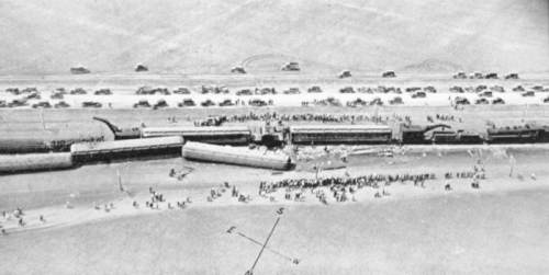
Tornadoes are known for their destructive power and unpredictable nature, but sometimes they can surprise us with their bizarre behavior. One such instance occurred on May 10, 1931, in the small town of Elgin, Texas, when a massive tornado picked up a train and carried it for over a mile before setting it back down on the tracks. This incredible event is one of the most unusual and fascinating stories in the history of tornadoes.
The Tornado: The tornado that struck Elgin, Texas, on that fateful day was a monster. It was estimated to be an F4 on the Fujita Scale, with winds reaching speeds of up to 260 miles per hour. The tornado touched down just outside of town and quickly grew in size and intensity as it made its way towards Elgin.
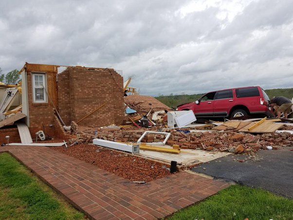
As the tornado approached the town, it began to cause significant damage. Houses were destroyed, trees were uprooted, and debris was scattered everywhere. But the most incredible damage was yet to come.
The Train: At the time of the tornado, a small train was making its way through Elgin. The train consisted of a locomotive and several cars carrying a load of gravel. As the tornado approached the tracks, the train crew had no idea what was about to happen.
Suddenly, the tornado struck the train with incredible force. The locomotive and cars were lifted off the tracks and carried into the air. Eyewitnesses reported seeing the train spinning and twisting in the vortex of the tornado, with gravel and debris flying everywhere.
The train was carried for over a mile by the tornado before being set back down on the tracks. Miraculously, the train remained intact and suffered only minor damage. The crew, who had taken shelter in the locomotive, emerged shaken but unharmed.
The Aftermath: News of the incredible event quickly spread, and people from all over the country came to Elgin to see the train that had been picked up by a tornado. The train became a local attraction, and people would come to take pictures and marvel at the incredible force of nature that had lifted it off the tracks.
The story of the tornado that picked up a train has become a legend in the history of tornadoes. It is a testament to the incredible power and unpredictable nature of these storms. It also serves as a reminder of the importance of taking tornado warnings seriously and seeking shelter when a tornado is approaching.
The Science Behind the Event: So, how did a tornado manage to pick up a train and carry it for over a mile? The answer lies in the incredible wind speeds and pressure changes that occur inside a tornado.
As a tornado moves across the landscape, it creates a low-pressure area at its center. This low-pressure area is surrounded by high-pressure areas on all sides. The difference in pressure creates incredibly strong winds that can reach speeds of up to 300 miles per hour.
When a tornado encounters an object, such as a train, the low-pressure area at the center of the tornado can create a vacuum effect. This vacuum can lift the object off the ground and carry it along with the tornado. The spinning motion of the tornado can also create centrifugal force, which can help to keep the object suspended in the air.
In the case of the Elgin tornado, the train was likely lifted off the tracks by the incredible wind speeds and pressure changes inside the tornado. The spinning motion of the tornado then carried the train for over a mile before setting it back down on the tracks.
Conclusion: The story of the tornado that picked up a train is a fascinating and bizarre tale that has captured the imagination of people for generations. It is a testament to the incredible power and unpredictable nature of tornadoes, and serves as a reminder of the importance of taking these storms seriously.
While the chances of a tornado picking up a train and carrying it for over a mile are incredibly slim, it is not impossible. Tornadoes are capable of incredible feats of strength and destruction, and we should never underestimate their power.
If you ever find yourself in the path of a tornado, remember the story of the Elgin tornado and seek shelter immediately. While the chances of being picked up by a tornado and carried for miles are slim, the consequences of not taking these storms seriously can be devastating.
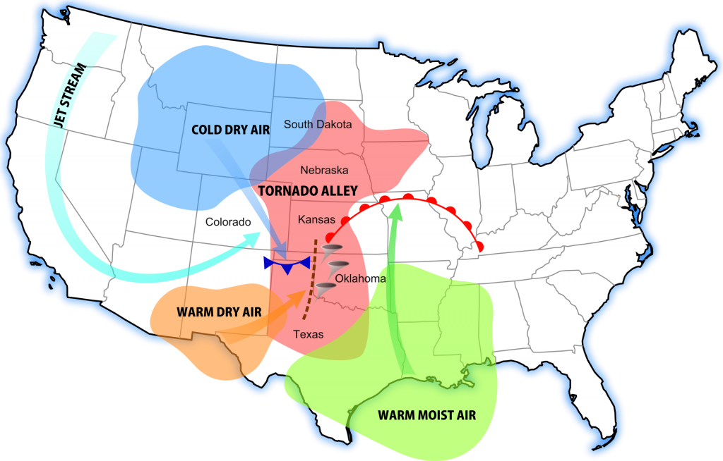
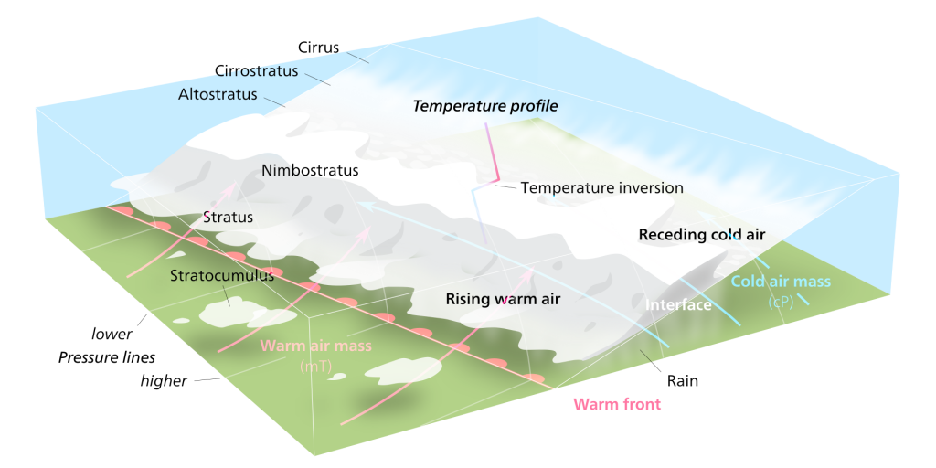
Storms are among the most powerful and awe-inspiring natural phenomena on Earth, capable of producing heavy rain, strong winds, large hail, and even tornadoes. But what causes these storms to form, and what factors influence their severity? The answer lies in the various types of atmospheric boundaries that exist in our atmosphere, including drylines, warm fronts, cold fronts, and outflow boundaries.
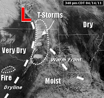
Drylines are a unique type of boundary that is most commonly found in the Great Plains region of the United States. A dryline separates warm, moist air from hot, dry air and is often characterized by a sharp contrast in temperature and humidity across the boundary. As the sun heats the ground during the day, the hot, dry air on one side of the dryline rises, creating a localized area of low pressure. This low-pressure area then draws in the warm, moist air from the other side of the boundary, setting the stage for severe thunderstorm development.
Dryline storms are notorious for their rapid development and intense nature. As the warm, moist air is forced upward by the rising hot, dry air, it cools and condenses, forming towering cumulus clouds that can quickly evolve into severe thunderstorms. These storms often produce large hail, damaging winds, and even tornadoes, making them a significant threat to life and property in the regions where they occur.
Warm fronts, on the other hand, are a type of boundary that occurs when a mass of warm air advances into a region of cooler air. As the warm air rises over the cooler air, it cools and condenses, forming clouds and precipitation. Warm front storms are generally characterized by widespread cloudiness, steady rain, and occasionally, thunderstorms.
One of the unique features of warm front storms is the gradual nature of their development. Unlike dryline storms, which can form and intensify rapidly, warm front storms tend to develop slowly over a period of several hours or even days. This slow development can lead to prolonged periods of rain and cloudiness, which can have significant impacts on local weather patterns and human activities.
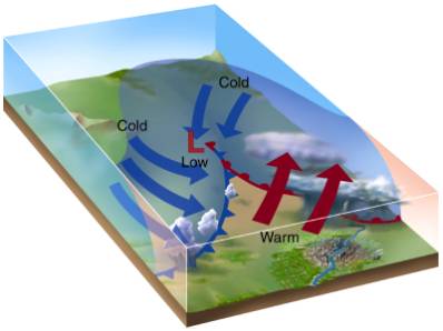
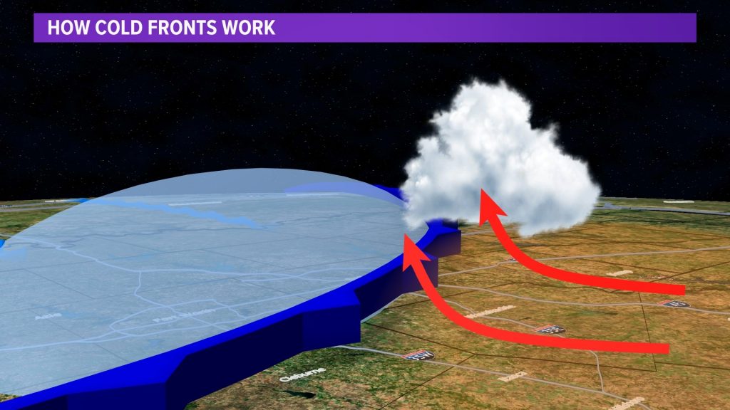
Cold fronts are perhaps the most well-known type of atmospheric boundary, and for a good reason. These boundaries occur when a mass of cold air overtakes a region of warmer air, forcing the warm air to rise rapidly. As the warm air rises, it cools and condenses, forming a line of intense thunderstorms known as a squall line.
Cold front storms are often accompanied by a dramatic change in weather conditions, with temperatures dropping sharply and winds shifting direction as the front passes through. These storms can produce a wide range of severe weather hazards, including damaging winds, large hail, and tornadoes, making them a significant threat to life and property.
Outflow boundaries are a type of boundary that forms when cool, dense air from a previous storm or rain-cooled air rushes out ahead of the storm, creating a mini cold front. As this cool air undercuts the warm, moist air ahead of it, it can trigger the development of new thunderstorms, often in a repeating cycle known as “training.”
Outflow boundary storms can be particularly dangerous because they can form quickly and with little warning, catching even the most prepared individuals off guard. These storms often produce heavy rain, strong winds, and occasionally, severe weather hazards such as large hail and tornadoes.
While atmospheric boundaries are a critical factor in the formation of severe storms, they are not the only factors at play. Moisture, instability, and wind shear are also essential ingredients in the development of severe thunderstorms and tornadoes. When these factors combine with a strong atmospheric boundary, the result can be a significant severe weather outbreak.
Drylines and Tornadoes: Drylines are known to be a significant factor in the formation of severe thunderstorms and tornadoes, particularly in the Great Plains region of the United States. A study by Hoch and Markowski (2005) found that “70% of all tornadoes in the southern Great Plains from 1999 to 2001 occurred within 100 km of a dryline.”
One notable example of a dryline-related tornado outbreak occurred on May 3, 1999, in Oklahoma and Kansas. According to the National Weather Service, this outbreak produced 74 tornadoes, including the devastating F5 tornado that struck Moore, Oklahoma, causing 36 fatalities and over $1 billion in damage.
Warm Fronts and Tornadoes: While warm fronts are less commonly associated with tornado formation than other boundary types, they can still contribute to the development of severe thunderstorms and occasional tornadoes. A study by Gaffin and Parker (2006) found that “approximately 10% of all tornadoes in the United States are associated with warm fronts.”
An example of a warm front-related tornado event occurred on March 2, 2012, in the Ohio Valley region. The National Weather Service reported that an EF4 tornado touched down in Henryville, Indiana, causing significant damage and 11 fatalities. This tornado was associated with a warm front that had been draped across the region, providing the necessary moisture and instability for severe storm development.
Cold Fronts and Tornadoes: Cold fronts are a well-known contributor to severe thunderstorm and tornado formation. A study by Trapp et al. (2005) found that “approximately 60% of all tornadoes in the United States are associated with cold fronts.”
The “Super Outbreak” of April 3-4, 1974, is a prime example of a cold front-related tornado event. During this outbreak, 148 tornadoes touched down across 13 states, causing 330 fatalities and over $600 million in damage (adjusted for inflation). The outbreak was associated with a powerful cold front that swept across the eastern United States, providing the necessary ingredients for widespread severe weather.
Outflow Boundaries and Tornadoes: Outflow boundaries, which are created by the cool, dense air that flows out of thunderstorms, can also contribute to tornado formation. A study by Markowski et al. (1998) found that “nearly 20% of all tornadoes in the central United States are associated with outflow boundaries.”
One example of an outflow boundary-related tornado event occurred on May 20, 2013, in Moore, Oklahoma. On this day, an EF5 tornado touched down, causing 24 fatalities and over $2 billion in damage. The tornado formed along an outflow boundary that had been generated by earlier thunderstorms in the area, highlighting the importance of these boundaries in severe weather formation.
Throughout history, artists and writers have been captivated by the power and beauty of the weather. From the gentle brush of a summer breeze to the fury of a raging storm, the elements have served as a source of inspiration for countless works of art and literature. In this article, we will explore how artists have captured the essence of weather in their creations and how it has shaped our perception of the natural world.
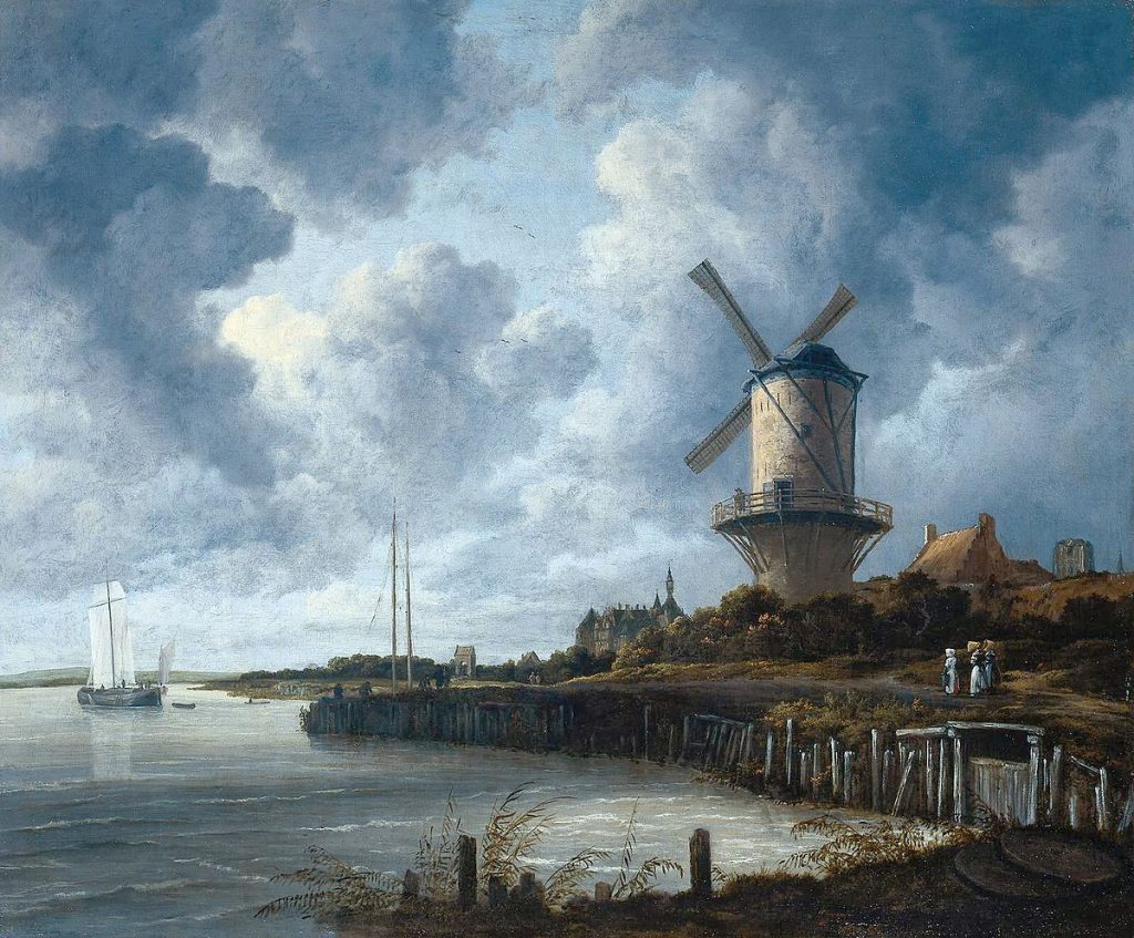
In the realm of visual arts, weather has been a recurring theme for centuries. One of the earliest examples can be found in the works of the Dutch Golden Age painters of the 17th century. Artists like Jacob van Ruisdael and Aelbert Cuyp were renowned for their landscapes that depicted the changing skies and atmospheric conditions of the Netherlands. Ruisdael’s “The Windmill at Wijk bij Duurstede” (1670) showcases a dramatic sky with billowing clouds and a windmill silhouetted against the light, capturing the essence of the Dutch countryside.
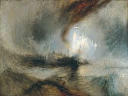
The Romantic era of the late 18th and early 19th centuries saw a surge in the representation of weather in art. Painters like J.M.W. Turner and Caspar David Friedrich were drawn to the sublime and awe-inspiring aspects of nature, often depicting turbulent seas, misty mountains, and stormy skies. Turner’s “Snow Storm: Steam-Boat off a Harbour’s Mouth” (1842) is a prime example of his mastery in conveying the raw power of the elements. The painting depicts a steamboat struggling against the fury of the wind and waves, with the sky and sea merging into a vortex of energy.
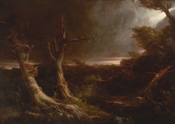
In “Tornado over the Wilderness” (1831), American painter Thomas Cole captures the terrifying majesty of a twister tearing through a desolate landscape. The canvas is dominated by the swirling vortex of the tornado, its funnel cloud descending from a dark and ominous sky. The twisted forms of trees and debris caught in the wind’s fury emphasize the destructive power of the storm, while a distant bolt of lightning illuminates the scene with an eerie, otherworldly glow. Cole’s painting serves as a reminder of nature’s untameable force and the insignificance of man in the face of such awesome might, a theme that resonated deeply with the Romantic sensibilities of the time.
In “Cottage Destroyed by Lightning” (1777), English artist Joseph Wright of Derby captures the devastating aftermath of a lightning strike on a rural cottage. The painting is dominated by the shattered ruins of the building, its roof and walls collapsed and smoldering in the wake of the powerful bolt. The dark, turbulent sky above is illuminated by a jagged streak of lightning, casting an eerie, unsettling light across the scene. Wright’s use of dramatic chiaroscuro and his attention to the details of the destruction emphasize the raw, destructive power of nature and the fragility of human life in the face of such overwhelming force.
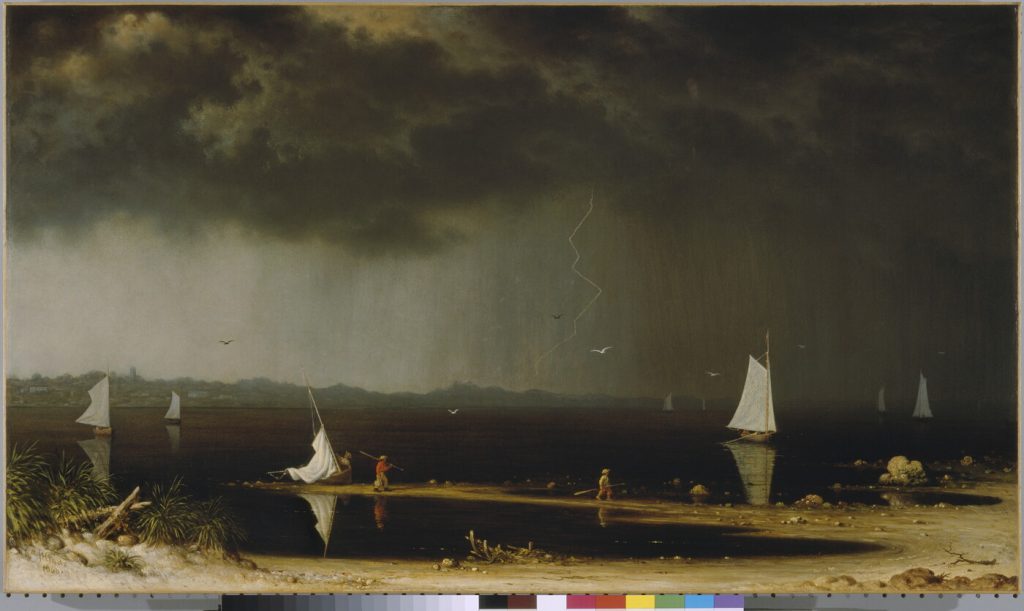
American painter Martin Johnson Heade’s “Thunderstorm on Narragansett Bay” (1868) depicts a dramatic moment during a powerful coastal storm. The canvas is divided between the dark, roiling clouds above and the choppy, wind-whipped waters below, with a distant shoreline barely visible through the haze. A brilliant flash of lightning illuminates the sky, its jagged bolt reflected in the turbulent waves and casting a stark, almost supernatural light across the scene. Heade’s precise, detailed brushwork and his skillful rendering of the atmospheric effects of the storm create a sense of both awe and unease, capturing the sublime beauty and terror of nature’s fury.
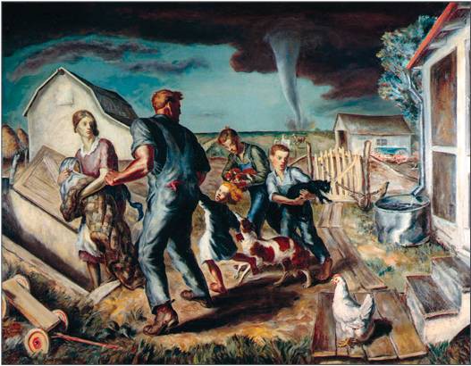
“The Tornado” (1927) by American painter John Steuart Curry. Although Curry was active in the early 20th century, this painting depicts a scene from the previous century. The canvas shows a massive, swirling tornado tearing through a rural landscape, with a farmhouse and barn being ripped apart by the powerful winds. The twister’s funnel cloud is rendered in shades of black and gray, conveying a sense of menace and destruction. In the foreground, a group of figures can be seen seeking shelter, their bodies bent against the force of the wind.
Impressionist painters of the late 19th century were also fascinated by the fleeting effects of light and weather on the landscape. Claude Monet, one of the most prominent figures of the movement, dedicated numerous series to capturing the changing light and atmosphere at different times of the day and in various weather conditions. His “Haystacks” series (1890-1891) depicts the same subject under different light and weather conditions, showcasing how the perception of color and form shifts with the changing elements.
Giorgione’s “The Tempest” (c. 1506-1508) is a masterpiece of Renaissance art that captures the intense drama of a powerful thunderstorm. In this enigmatic painting, a dark and foreboding sky looms over a lush landscape, punctuated by streaks of lightning that illuminate the scene with an eerie glow. The figures in the foreground, a nude woman nursing a child and a soldier standing nearby, appear small and vulnerable against the backdrop of the raging storm, highlighting the awesome power of nature. Giorgione’s use of chiaroscuro, the interplay of light and shadow, adds to the sense of mystery and unease that pervades the painting, inviting the viewer to contemplate the deeper meanings behind this haunting image.
In Rembrandt van Rijn’s “The Storm on the Sea of Galilee” (1633), the Dutch master depicts the biblical story of Jesus calming the storm, capturing the terror and chaos of the moment with his signature mastery of light and shadow. The painting shows the disciples’ boat being tossed about by the turbulent waves, their faces contorted in fear as they struggle against the raging wind and water. Rembrandt’s use of dramatic contrasts, with the dark sky and sea juxtaposed against the bright highlights on the figures and boat, heightens the sense of danger and desperation. The composition draws the viewer’s eye to the figure of Christ, who stands calmly amidst the chaos, his hand raised in a gesture of command, demonstrating his divine power over the elements.
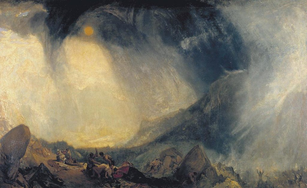
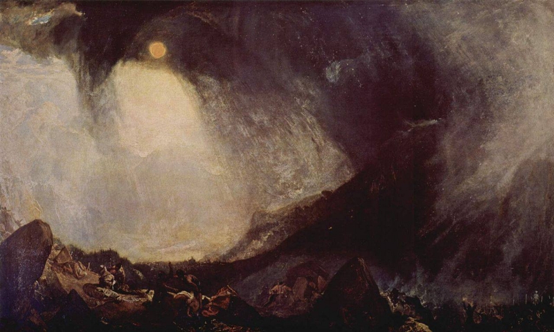
English Romantic painter J.M.W. Turner’s “Snowstorm: Hannibal and his Army Crossing the Alps” (1812) is a powerful example of the artist’s fascination with the sublime forces of nature. The painting depicts the legendary Carthaginian general Hannibal leading his army across the treacherous Alps, battling against a fierce blizzard that threatens to engulf them. Turner’s swirling brushstrokes and pale, almost monochromatic color scheme convey the disorienting fury of the snowstorm, with the tiny figures of Hannibal and his soldiers nearly lost amidst the maelstrom. The painting serves as a testament to the awesome power of nature and the insignificance of human endeavors in the face of such overwhelming might, a central theme of the Romantic movement that Turner helped to define.
In the 20th century, artists continued to explore the theme of weather in their works. American painter Georgia O’Keeffe, known for her abstract depictions of nature, often incorporated elements of the sky and clouds in her paintings. Her “Sky Above Clouds IV” (1965) presents a vast expanse of clouds viewed from above, inviting the viewer to contemplate the immensity and beauty of the atmosphere.
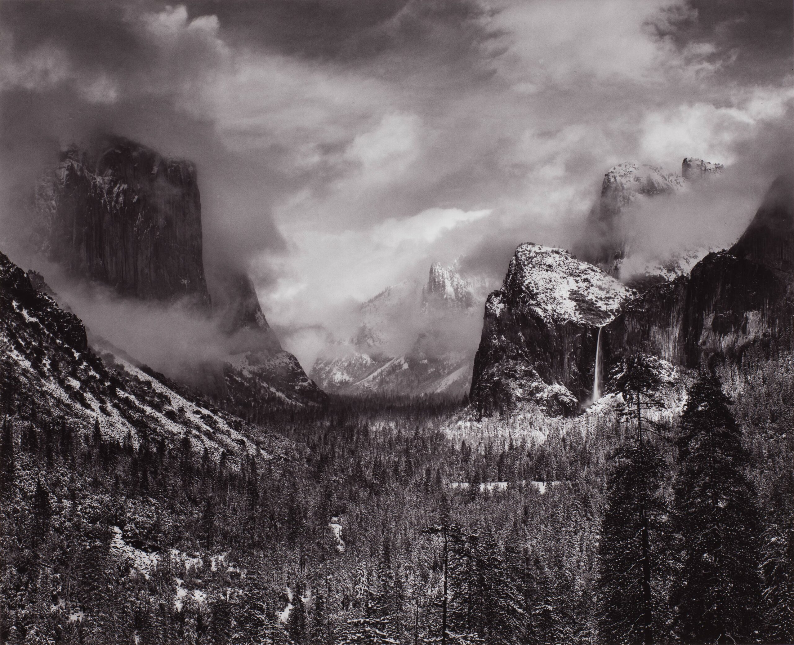
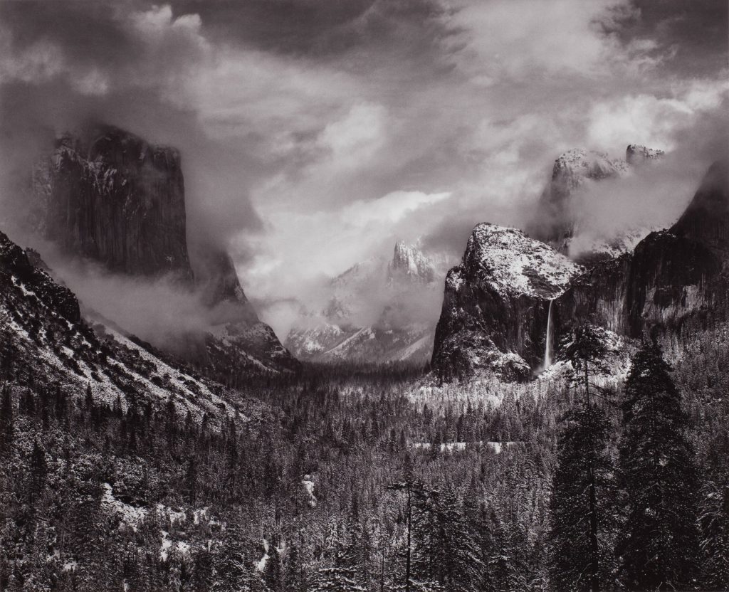
Photography has also played a significant role in capturing the essence of weather. Ansel Adams, one of the most influential photographers of the 20th century, was renowned for his black and white landscapes that often featured dramatic skies and atmospheric conditions. His photograph “Clearing Winter Storm, Yosemite National Park” (1944) depicts the aftermath of a storm, with mist rising from the valley and sunlight breaking through the clouds, creating a sense of tranquility and renewal.
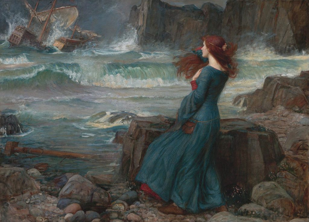
In literature, weather has been used as a powerful tool to set the mood, reflect the emotions of characters, and symbolize deeper themes. Shakespeare frequently employed weather as a metaphor in his plays, with storms and tempests often representing the inner turmoil of his protagonists. In “King Lear,” the raging storm on the heath mirrors the madness and despair of the titular character, while in “The Tempest,” the storm that opens the play serves as a catalyst for the events that unfold.
The Romantic poets of the 19th century, such as William Wordsworth and Percy Bysshe Shelley, often drew inspiration from the natural world and the changing seasons. Wordsworth’s “I Wandered Lonely as a Cloud” (1807) captures the joy and wonder of stumbling upon a field of daffodils on a breezy spring day, while Shelley’s “Ode to the West Wind” (1819) invokes the power of the wind as a force of change and renewal.
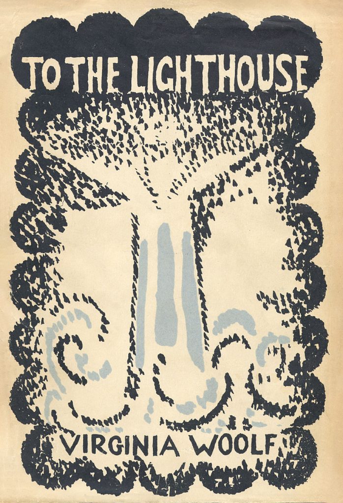
In the 20th century, modernist writers like Virginia Woolf and James Joyce used weather to create atmosphere and reflect the inner lives of their characters. In Woolf’s “To the Lighthouse” (1927), the shifting weather patterns at the seaside mirror the changing dynamics of the Ramsay family, while in Joyce’s “Ulysses” (1922), the city of Dublin is brought to life through vivid descriptions of the weather and its effects on the characters’ moods and actions.
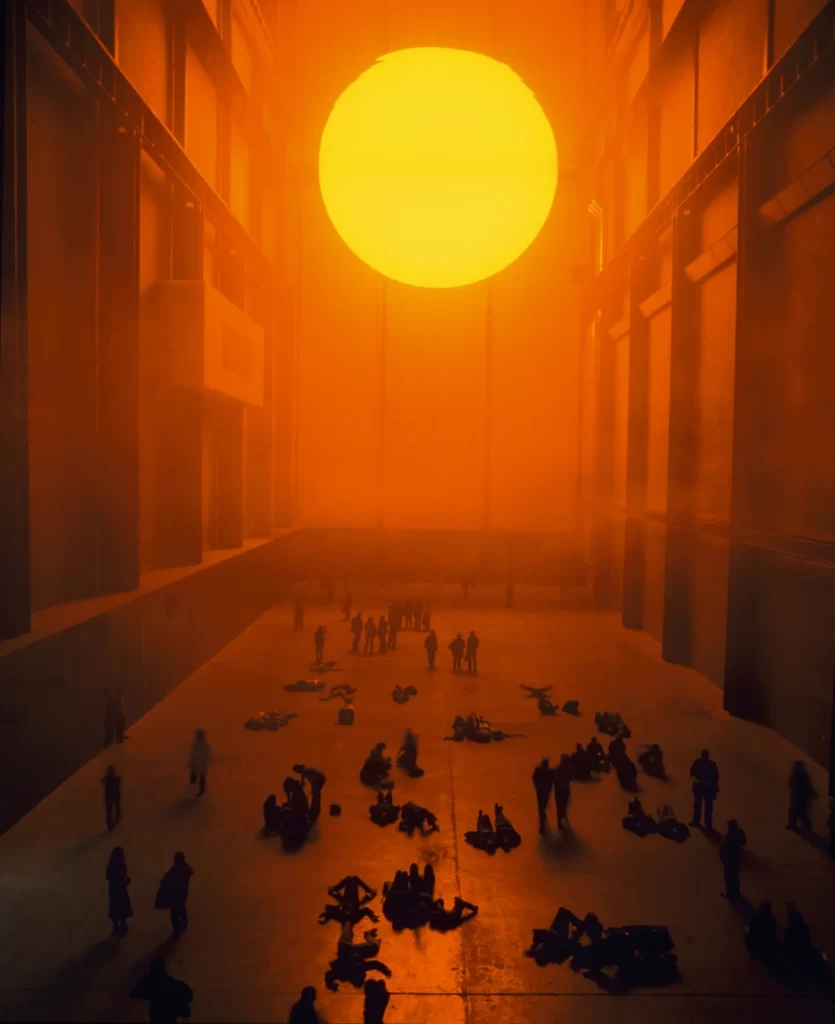
Contemporary artists and writers continue to be inspired by the weather and its many manifestations. In the world of installation art, artists like Olafur Eliasson have created immersive environments that simulate natural phenomena, such as his “The Weather Project” (2003) at the Tate Modern, which recreated the experience of a giant sun in the museum’s turbine hall. In literature, authors like Amitav Ghosh have explored the impact of climate change and extreme weather events on human lives and communities, as seen in his novel “The Hungry Tide” (2004), set in the Sundarbans delta of India and Bangladesh.
The representation of weather in art and literature serves as a reminder of our deep connection to the natural world and the power of the elements to shape our experiences and emotions. Whether captured in paint, pixels, or words, the ever-changing face of the weather continues to captivate and inspire artists and writers, inviting us to marvel at the beauty and complexity of the world around us.
From the gentle brush strokes of the Dutch Golden Age painters to the immersive installations of contemporary artists, weather has been a constant presence in the history of art. It has served as a source of inspiration, a metaphor for the human condition, and a reminder of the awesome power of nature. Similarly, in literature, weather has been used to create atmosphere, reflect the inner lives of characters, and explore deeper themes of change, renewal, and the human relationship with the environment.
1.Reinforced concrete: Reinforced concrete is one of the most tornado-resistant materials due to its high strength and durability. The combination of concrete and embedded steel reinforcement provides excellent resistance to high winds and flying debris. Walls made of reinforced concrete should be at least 6 inches thick to provide adequate protection.
2. Steel: Steel is another strong material that can withstand the forces of a tornado. Steel structures, such as shipping containers or specially designed safe rooms, can provide a high level of protection when anchored properly to a concrete foundation.
3. Brick and masonry: While not as strong as reinforced concrete, brick and masonry structures can still offer some protection during a tornado. However, it’s important to note that unreinforced masonry can be vulnerable to collapse under extreme winds. Reinforced masonry, with steel reinforcements embedded in the mortar joints, provides a higher level of protection.
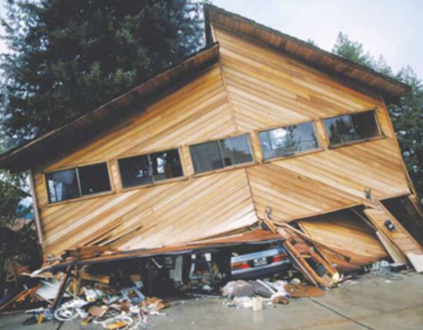
4, Wood: Wood structures are the most vulnerable to tornado damage due to their lightweight nature and susceptibility to flying debris. However, wood-framed homes can be strengthened with the use of hurricane clips, anchor bolts, and other connectors that help tie the structure together and improve its overall resistance to wind forces.
Rooms and Structures:
Basements: Basements are one of the safest places to be during a tornado, as they are below ground level and surrounded by earth, which provides natural protection. The basement walls should be made of reinforced concrete or reinforced masonry for optimal protection. If possible, choose a corner of the basement away from windows and exterior walls.
Interior rooms: Small, interior rooms on the lowest floor of a building, such as closets, bathrooms, or hallways, can provide some protection during a tornado. These rooms should be located away from exterior walls and windows. The smaller the room, the better, as it will have less space for potential debris to accumulate.
Bathtubs: If you don’t have access to a basement or a small interior room, a bathtub can provide some protection. Bathtubs are typically made of sturdy materials like cast iron or steel, which can withstand some impact from debris. Lie in the bathtub and cover yourself with a thick blanket or mattress for added protection.
Closets: A small, interior closet can be a good place to seek shelter during a tornado. Choose a closet on the lowest floor, away from exterior walls and windows. The closet should have a strong door frame and hinges to resist wind forces.
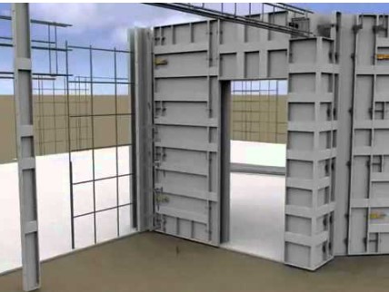
Safe rooms: Specially designed safe rooms, built to FEMA guidelines, offer the highest level of protection during a tornado. These rooms are typically constructed with reinforced concrete or steel and are anchored securely to a concrete foundation. The walls, ceiling, and door are designed to withstand extreme wind speeds and flying debris.
Doorways: While it is a common misconception that doorways are safe during a tornado, they do not provide significant protection unless they are part of a specially designed safe room. In fact, doorways can be dangerous due to the potential for flying debris and the lack of structural support in modern homes.
If you’re building a new home, here are some important considerations:
Continuous load path: Ensure that your home’s design incorporates a continuous load path, which means that all structural elements (roof, walls, and foundation) are properly connected to transfer wind forces down to the ground. This can be achieved through the use of metal connectors, anchor bolts, and reinforced concrete.
Impact-resistant windows and doors: Install impact-resistant windows and doors, which are designed to withstand high winds and flying debris. These may include laminated glass, reinforced frames, and sturdy hardware.
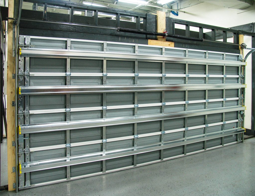
Reinforced garage doors: Garage doors are often a weak point in a home’s structure during a tornado. Install reinforced garage doors that are designed to withstand high winds, or consider eliminating the garage altogether and opting for a carport or detached garage.
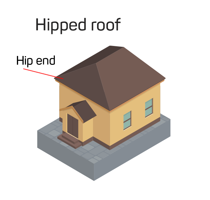
Hip roof design: A hip roof (slopes on all four sides) is more aerodynamic and resistant to wind forces than a gable roof (slopes on two sides). If possible, incorporate a hip roof design with a 30-45 degree slope to minimize wind uplift forces.
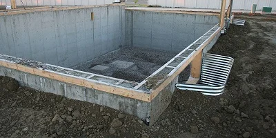
Proper anchoring: Ensure that your home’s foundation is properly anchored to the ground using anchor bolts or other suitable methods. This helps prevent the structure from being lifted or shifted off its foundation during a tornado.
Minimize overhangs and projections: Reduce the size of roof overhangs, balconies, and other projections, as these can be vulnerable to wind forces and provide a pathway for wind to enter the structure.
Properly anchoring the roof to the walls is a critical aspect of creating a continuous load path and ensuring that your home can resist the high wind forces associated with tornadoes. The goal is to create a strong, uninterrupted connection from the roof to the walls and down to the foundation. Here are some recommendations for anchoring the roof to the walls:
Hurricane clips or straps: Use hurricane clips or straps to connect the roof trusses or rafters to the top plate of the exterior walls. These metal connectors are designed to resist uplift forces and prevent the roof from being separated from the walls during high winds. Hurricane clips should be installed according to the manufacturer’s specifications and local building codes.
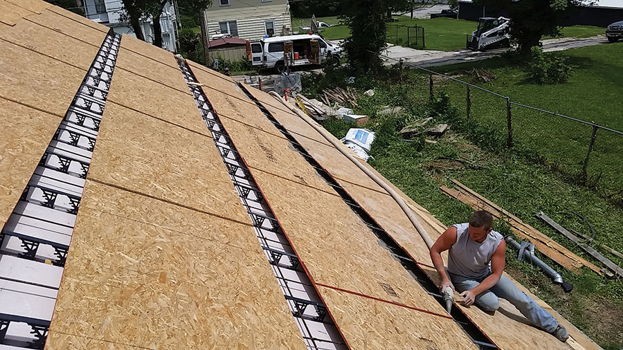
Continuous roof sheathing: Use continuous roof sheathing, such as plywood or oriented strand board (OSB), to create a solid, uninterrupted surface that can distribute wind forces across the entire roof. The sheathing should be properly fastened to the roof trusses or rafters with ring-shank nails or screws.
Roof-to-wall anchors: In addition to hurricane clips, consider using roof-to-wall anchors, which are heavy-duty metal connectors that tie the roof framing directly to the wall studs. These anchors provide a more robust connection and can further improve the roof’s resistance to uplift forces.
Reinforced roof-to-wall connections: For added strength, consider using reinforced roof-to-wall connections, such as continuous steel straps or cables that run from the roof framing, down the exterior walls, and into the foundation. These continuous ties help transfer wind forces from the roof to the foundation, bypassing the potential weak points at the wall-to-foundation connection.
Proper fastening: Ensure that all connections, including roof sheathing, hurricane clips, and anchors, are fastened using the appropriate fasteners (e.g., ring-shank nails or structural screws) and fastening patterns as specified by the manufacturer and local building codes.
Gable end bracing: If your home has a gable roof, pay special attention to the gable end walls, as these are particularly vulnerable to wind forces. Install gable end bracing, such as diagonal braces or shear walls, to provide additional support and prevent the gable end from collapsing during a tornado.
Professional installation: Have your roof-to-wall connections designed and installed by experienced professionals, such as licensed contractors or structural engineers, to ensure that they meet or exceed the requirements for your area’s wind loads and building codes.
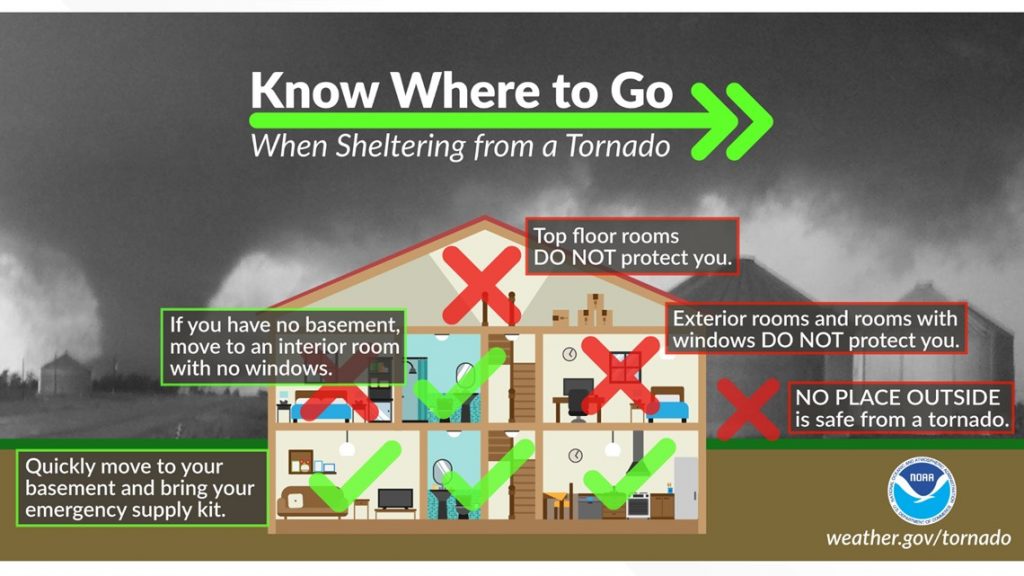
When it comes to surviving a tornado, having a dedicated storm shelter or safe room built to FEMA guidelines is the best option. However, if you don’t have access to a shelter, there are still certain types of rooms, places, home designs, materials, and structures that can increase your chances of survival during a tornado.
Basements: If your home has a basement, it is one of the safest places to be during a tornado. The below-ground location provides added protection from flying debris and the collapse of the structure above. Choose a corner of the basement away from windows and exterior walls. If possible, get under a sturdy piece of furniture like a table or workbench for added protection.
Interior rooms: If you don’t have a basement, seek shelter in a small, interior room on the lowest floor of your home. Closets, bathrooms, and hallways are often good choices, as they are typically located away from exterior walls and have a smaller area that can be more easily reinforced. In a bathroom, the plumbing in the walls can provide additional structural support.
Center of the house: The center of your home is usually the most structurally sound area, as it is furthest from the exterior walls that are more vulnerable to damage from high winds and flying debris.
Rooms with no windows: Windows are weak points in your home’s structure and can easily shatter during a tornado, creating a dangerous situation with flying glass. Choose a room with no windows or the fewest windows possible.
Manufactured homes: Manufactured homes, also known as mobile homes, are particularly vulnerable to tornadoes due to their lightweight construction and lack of a solid foundation. If you live in a manufactured home, it is crucial to have a separate storm shelter or evacuate to a sturdy building before the tornado hits.
Concrete and brick structures: Homes made of concrete or brick are generally more resistant to tornado damage than those made of wood or other lightweight materials. The added weight and strength of these materials can help the structure withstand high winds and flying debris.
Safe rooms: If you don’t have a basement or storm shelter, consider building or installing a safe room in your home. These rooms are specifically designed to withstand extreme winds and flying debris. They can be constructed from reinforced concrete, steel, or other materials and should be anchored securely to a solid foundation.
Helmets and protective covering: Regardless of where you take shelter, protect your head and neck by wearing a helmet, such as a bicycle or motorcycle helmet. Cover your body with thick blankets, sleeping bags, or even a mattress to shield yourself from flying debris.
Avoid certain areas: During a tornado, stay away from exterior walls, doors, and windows. Also, avoid rooms with large spans, such as gymnasiums, auditoriums, or warehouses, as the roof is more likely to collapse in these spaces.
Community shelters: If your home does not have a suitable place to take shelter, familiarize yourself with community shelters in your area. These can include schools, public buildings, or designated storm shelters.
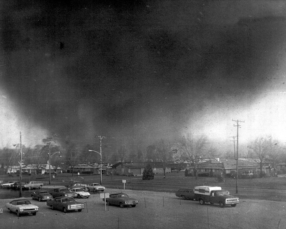
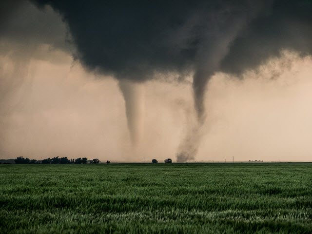
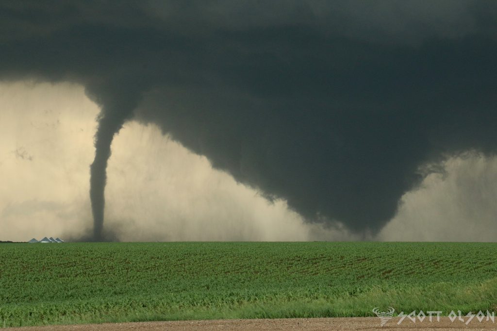
Tornadoes are one of the most destructive and fascinating weather phenomena on Earth. These rapidly rotating columns of air can cause significant damage and pose a serious threat to life and property. While most people are familiar with the concept of a single tornado, the question of whether two tornadoes can exist simultaneously is a topic of interest for meteorologists and weather enthusiasts alike. In this article, we will explore the possibility of concurrent tornadoes, focusing on the processes of cyclic tornadogenesis and occluding mesocyclones.
Cyclic Tornadogenesis: Cyclic tornadogenesis is a process by which a supercell thunderstorm produces multiple tornadoes over its lifetime. This phenomenon occurs when a supercell’s mesocyclone (a rotating updraft) undergoes a series of cycles, each producing a new tornado. As the first tornado dissipates, the mesocyclone reorganizes and gives birth to a subsequent tornado. This process can repeat several times, resulting in a series of tornadoes forming from the same parent supercell.
Research has shown that cyclic tornadogenesis is more likely to occur in environments with strong wind shear and high instability. A study by Adlerman and Droegemeier (2005) used high-resolution numerical simulations to investigate the mechanisms behind cyclic mesocyclogenesis. They found that the cycling process is driven by the interaction between the rear-flank downdraft (RFD) and the updraft, which leads to the formation of a new mesocyclone and subsequent tornadogenesis.
Occluding Mesocyclones and Simultaneous Tornadoes: An occluding mesocyclone is a mesocyclone that is in the process of dissipating, often due to the ingestion of cooler, more stable air from the rear-flank downdraft. During this occlusion process, it is possible for the original tornado to still be present while a new mesocyclone and tornado are forming. This scenario can lead to the presence of two simultaneous tornadoes.
On June 16, 2014, the town of Pilger, Nebraska, experienced a rare and devastating tornado event. Two tornadoes, both rated as violent EF-4, touched down simultaneously and caused significant damage to the town. This event is a notable example of simultaneous tornadoes occurring as a result of cyclic tornadogenesis.
The Pilger tornado event was well-documented by storm chasers and researchers, providing valuable data for studying the formation and evolution of these concurrent tornadoes. Wicker et al. (2015) analyzed the event using high-resolution radar data and found evidence of cyclic mesocyclogenesis. The study revealed that the two tornadoes formed from separate mesocyclones within the same supercell thunderstorm, with the second tornado developing as the first one was weakening.
The simultaneous occurrence of the Pilger tornadoes highlights the complexity of cyclic tornadogenesis and the potential for multiple tornadoes to form within a single supercell. This event also emphasizes the importance of advanced radar technology and real-time observations in understanding and forecasting these rare and dangerous phenomena.
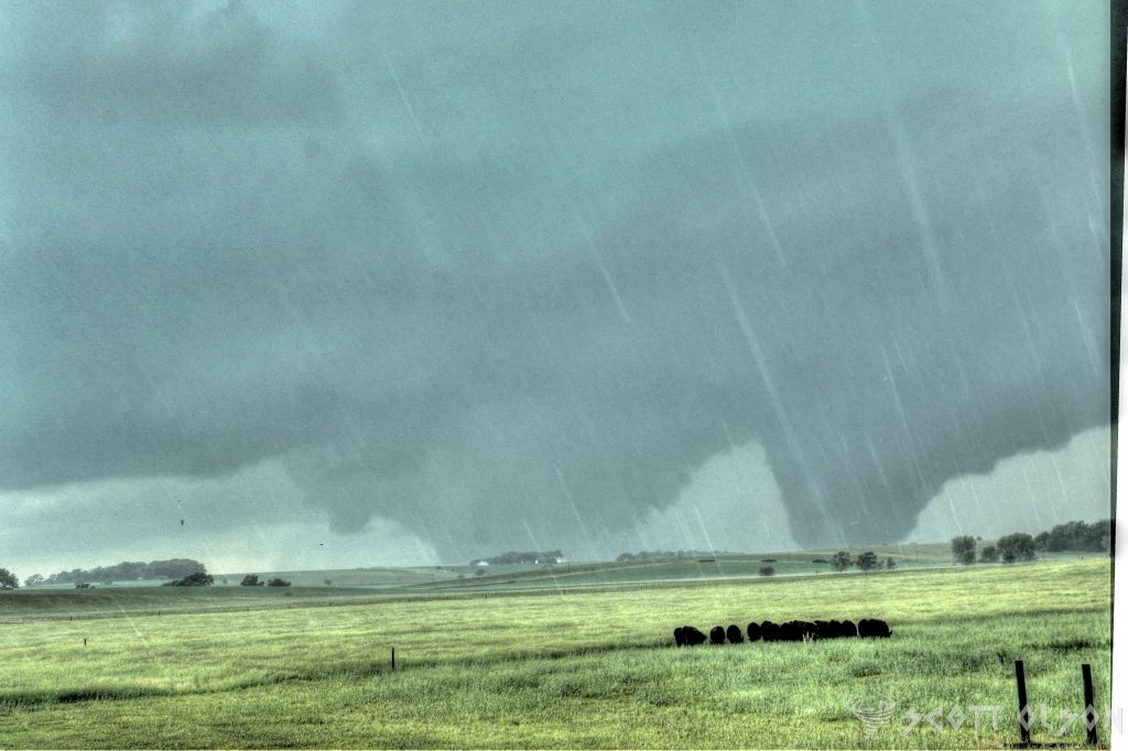
Multi-Vortex Tornadoes: Multi-vortex tornadoes are another fascinating aspect of tornado dynamics. These tornadoes are characterized by the presence of multiple smaller vortices rotating around a central axis. While multi-vortex tornadoes are not the same as simultaneous tornadoes, they demonstrate the complex nature of tornado structure and the potential for multiple vortices to exist within a single tornado.
Agee et al. (1977) conducted one of the earliest studies on multi-vortex tornadoes, using photographs and films to analyze the structure and evolution of these tornadoes. They found that multi-vortex tornadoes often exhibit a cyclic behavior, with vortices forming, merging, and dissipating over time. This cyclic nature of multi-vortex tornadoes is similar to the cyclic tornadogenesis process observed in supercell thunderstorms.
More recent studies, such as those by Wurman and Kosiba (2013) and Wakimoto et al. (2016), have used high-resolution mobile Doppler radar data to investigate the dynamics of multi-vortex tornadoes. These studies have revealed the complex interactions between the main vortex and the smaller subvortices, as well as the role of surface friction and debris in modulating the structure and intensity of multi-vortex tornadoes.
The presence of multiple vortices can lead to more erratic and unpredictable tornado paths, as well as localized areas of intense damage. Additionally, the cyclic nature of multi-vortex tornadoes can make it challenging to issue timely and accurate warnings, as the tornado’s intensity and structure can change rapidly.
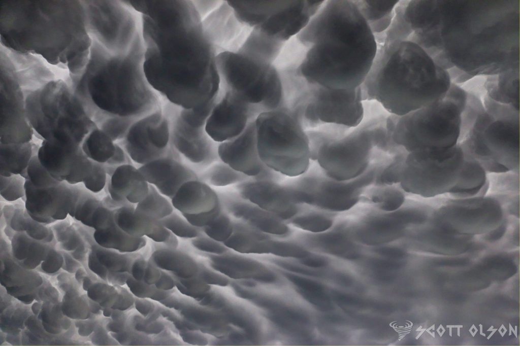
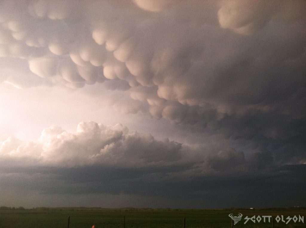
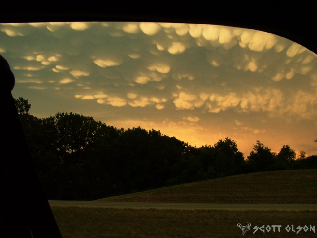
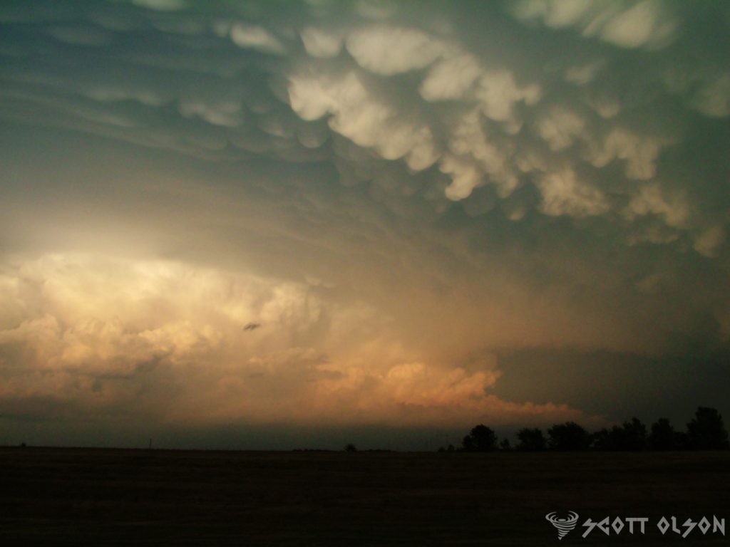
Have you ever gazed up at the sky and witnessed a mesmerizing display of pouches or bubble-like structures hanging from the underside of a cloud? If so, you’ve had the privilege of observing one of nature’s most captivating phenomena: mammatus clouds. These distinctive formations have intrigued scientists, photographers, and cloud enthusiasts alike for centuries, and their appearance never fails to leave observers in awe.
Mammatus clouds, scientifically known as mammatocumulus, are a rare and stunning sight to behold. The term “mammatus” is derived from the Latin word “mamma,” meaning “udder” or “breast,” which aptly describes the appearance of these clouds. They are characterized by their unique pouch-like protrusions that hang down from the base of a cloud, creating a striking visual contrast against the sky.
The formation of mammatus clouds is a complex process that involves a combination of atmospheric conditions. These clouds typically occur in association with large cumulonimbus clouds, which are the towering thunderstorm clouds responsible for heavy rainfall, lightning, and even tornadoes. As the cumulonimbus cloud begins to dissipate, the sinking motion of cold air within the cloud can cause the formation of mammatus clouds.
One of the leading theories behind the formation of mammatus clouds suggests that they are the result of a process called “cloud-base detrainment.” This occurs when cold, dense air from the upper parts of the cumulonimbus cloud sinks and pushes into the warmer, more humid air below. As the cold air descends, it creates a series of lobes or pouches that protrude from the bottom of the cloud, giving rise to the distinctive mammatus appearance.
Another factor that contributes to the formation of mammatus clouds is the presence of strong wind shear. Wind shear refers to the change in wind speed or direction with height in the atmosphere. When there is a significant difference in wind speed or direction between the upper and lower levels of a cumulonimbus cloud, it can cause the cloud to become unstable and promote the development of mammatus structures.
The sight of mammatus clouds is not only visually stunning but also a testament to the incredible forces at work in Earth’s atmosphere. These clouds often appear during severe weather events, such as thunderstorms or even tornadoes, adding an element of drama and intensity to the sky. The pouches can range in size from small, grape-like structures to large, udder-like protrusions that can span several kilometers in length.
Mammatus clouds are not only a treat for the eyes but also a subject of fascination for scientists and researchers. While the exact mechanisms behind their formation are still being studied, these clouds serve as a reminder of the complex and dynamic nature of our atmosphere. They showcase the delicate interplay between temperature, humidity, and wind, resulting in a breathtaking display that captures the imagination of all who witness it.
For photographers and cloud enthusiasts, mammatus clouds present a unique opportunity to capture nature’s artistry at its finest. The contrast between the dark, ominous base of the cumulonimbus cloud and the soft, billowing pouches of the mammatus creates a striking visual composition that is both eerie and beautiful. Many photographers spend hours chasing storms and waiting patiently for the perfect moment to capture these elusive clouds in all their glory.
Beyond their aesthetic appeal, mammatus clouds also serve as an important indicator of atmospheric conditions. Their presence often signifies the potential for severe weather, such as strong winds, hail, or even tornadoes. Meteorologists and weather forecasters pay close attention to the development of mammatus clouds, as they can provide valuable insights into the stability of the atmosphere and the likelihood of extreme weather events.
Mammatus clouds are a true marvel of nature, captivating the hearts and minds of people around the world. Their unique appearance, born from the complex interplay of atmospheric conditions, serves as a reminder of the awe-inspiring beauty and power of our planet’s weather systems. Whether you are a scientist, photographer, or simply someone who appreciates the wonders of the natural world, the sight of mammatus clouds is an unforgettable experience that will leave you marveling at the incredible forces at work in the sky above us.
So the next time you find yourself gazing up at a stormy sky, keep an eye out for these mesmerizing pouches of clouds. Take a moment to appreciate the intricate dance of nature’s elements that come together to create such a spectacular display.
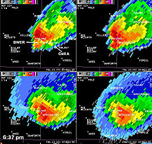
Radar meteorology is one of the most important tools for monitoring and predicting severe weather events. By analyzing radar data, meteorologists can identify specific features that indicate the presence of dangerous storms, such as supercell thunderstorms and tornadoes. In this article, we will discuss some of the most common radar features to look for when assessing severe weather threats.
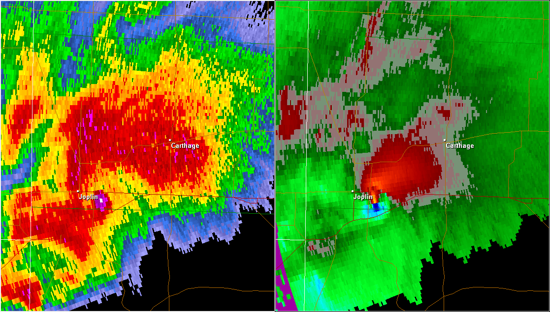
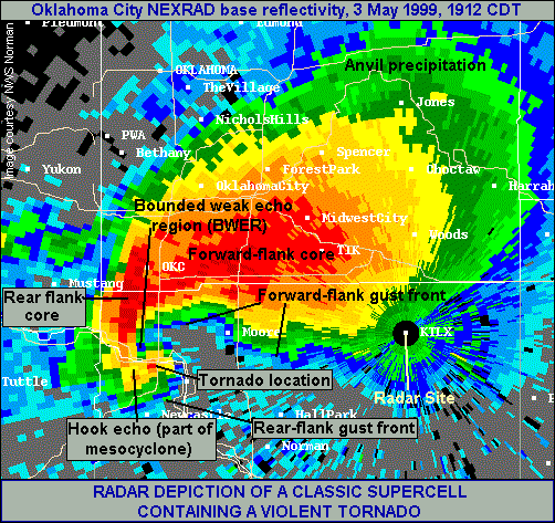
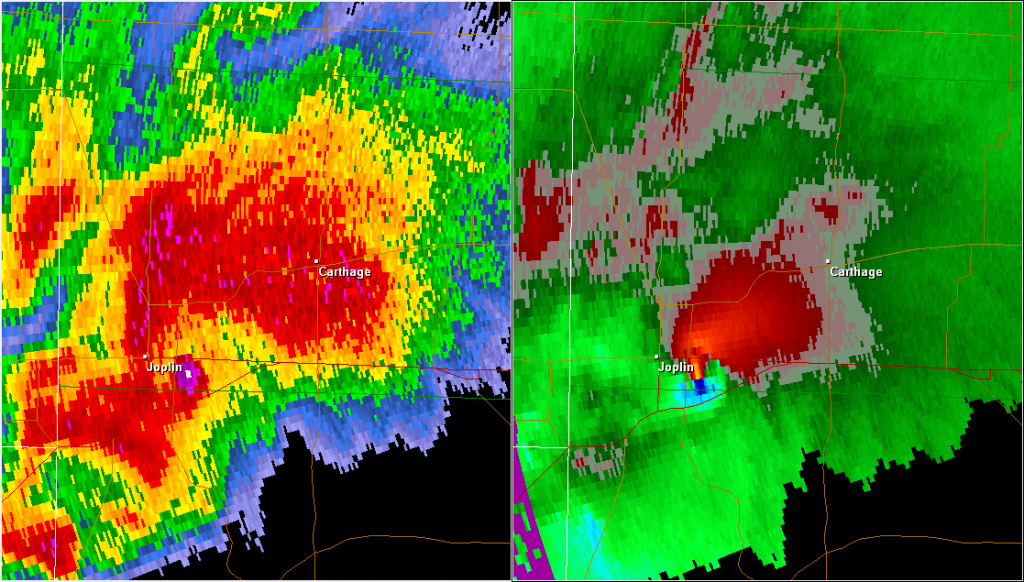
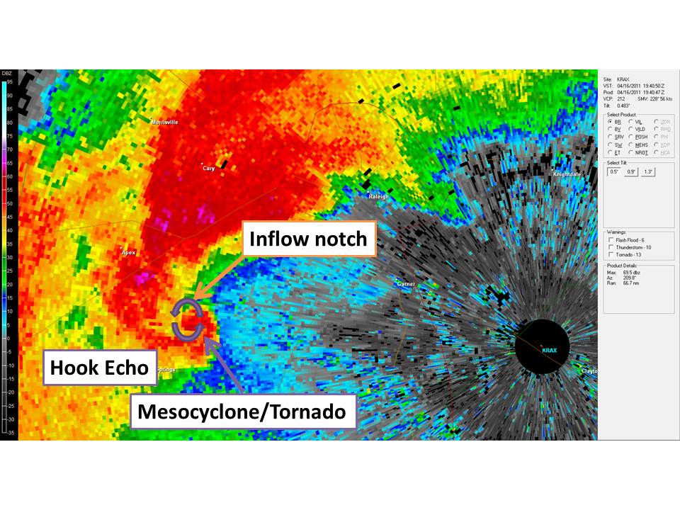
Hook Echo: A hook echo is a distinctive radar signature that often indicates the presence of a supercell thunderstorm capable of producing tornadoes. This feature appears as a hook-shaped appendage extending from the main storm cell on the radar display. The hook shape is formed by the rotation of the storm’s updraft, which can cause rain and hail to wrap around the updraft, creating a hook-like appearance.
When a hook echo is detected, it is essential to monitor the storm closely, as it has a higher likelihood of producing a tornado. The tightness and persistence of the hook echo can provide clues about the storm’s intensity and potential for tornadogenesis. A tight, well-defined hook echo that persists for an extended period is more likely to be associated with a strong, long-lived tornado.
Bow Echo: A bow echo is a radar signature that indicates the presence of a strong, linear wind storm known as a derecho. This feature appears as a bow-shaped line of storms on the radar display, with the apex of the bow pointing in the direction of the storm’s movement. Bow echoes are often associated with widespread damaging winds, which can exceed 100 mph in extreme cases.
The formation of a bow echo is related to the development of a strong rear-inflow jet behind the main line of storms. This jet of fast-moving air descends to the surface and spreads out, causing the line of storms to bow outward. As the rear-inflow jet continues to strengthen, it can lead to the formation of embedded circulations within the line, known as mesovortices, which can produce brief, spin-up tornadoes.
Debris Ball: A debris ball, also known as a tornado debris signature (TDS), is a radar feature that indicates the presence of lofted debris associated with a tornado. This signature appears as a localized area of high reflectivity (bright colors) on the radar display, often coinciding with the location of a hook echo or other tornado-related features.
The debris ball is caused by the tornado lofting large amounts of debris, such as trees, building materials, and other objects, high into the air. When the radar beam intersects this debris, it produces a strong return signal, which appears as a bright, concentrated area on the radar display. The presence of a debris ball is a strong indication that a tornado is causing damage on the ground.
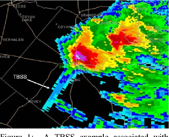
Three-Body Scatter Spike (TBSS): A three-body scatter spike is a radar signature that can indicate the presence of a large hail core within a thunderstorm. This feature appears as a narrow, linear spike of high reflectivity extending radially outward from the storm on the radar display. The TBSS is caused by the radar beam reflecting off a layer of large hailstones and then reflecting again off the ground before returning to the radar.
The presence of a TBSS suggests that the storm contains a significant amount of large hail, which can cause extensive damage to property and pose a serious risk to public safety. When a TBSS is detected, it is important to issue warnings for large hail and to advise people to seek shelter immediately.
Bounded Weak Echo Region (BWER): A bounded weak echo region is a radar feature that indicates the presence of a strong, persistent updraft within a thunderstorm. This feature appears as a localized area of low reflectivity (dark colors) surrounded by higher reflectivity values on the radar display. The BWER is caused by the strong updraft lifting precipitation particles high into the storm, creating a region of relatively low radar returns.
The presence of a BWER suggests that the storm has a powerful updraft, which can support the formation of large hail and tornadoes. When a BWER is detected, it is important to monitor the storm closely for the development of other severe weather signatures, such as hook echoes or debris balls.
Inflow Notch: An inflow notch is a radar signature that indicates the presence of strong, localized inflow into a thunderstorm. This feature appears as a small, localized area of low reflectivity (dark colors) along the leading edge of the storm on the radar display. The inflow notch is caused by the rapid inflow of warm, moist air into the storm, which can fuel the development of strong updrafts and severe weather.
The presence of an inflow notch suggests that the storm is actively ingesting warm, moist air, which can lead to rapid intensification and the formation of severe weather hazards, such as large hail, damaging winds, and tornadoes. When an inflow notch is detected, it is important to monitor the storm closely for the development of other severe weather signatures.
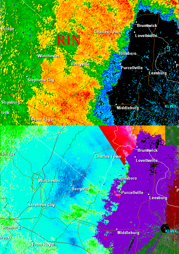
Rear Inflow Notch (RIN): A rear inflow notch is a radar feature that indicates the presence of strong, localized inflow into the back side of a thunderstorm. This feature appears as a small, localized area of low reflectivity (dark colors) along the rear flank of the storm on the radar display. The RIN is caused by the rapid inflow of cooler, drier air into the storm, which can help to strengthen the storm’s updraft and increase the potential for severe weather.
The presence of a RIN suggests that the storm is actively ingesting cooler, drier air on its back side, which can lead to the formation of a strong rear-flank downdraft (RFD). The RFD can help to tighten the storm’s rotation and increase the risk of tornadogenesis. When a RIN is detected, it is important to monitor the storm closely for the development of hook echoes, debris balls, and other tornado-related signatures.
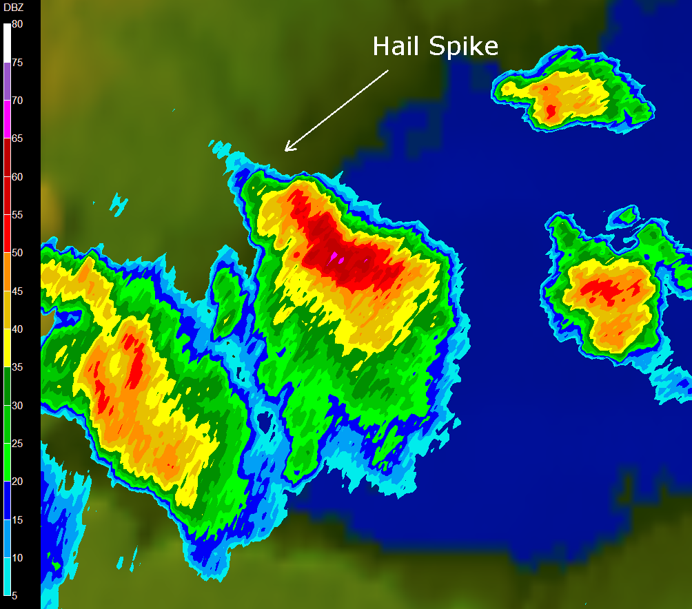
Hail Spike: A hail spike is a radar signature that indicates the presence of a strong updraft capable of producing large hail. This feature appears as a narrow, vertical spike of high reflectivity extending upward from the storm on the radar display. The hail spike is caused by the strong updraft lofting large hailstones high into the storm, where they can grow even larger before falling back to the ground.
The presence of a hail spike suggests that the storm has a powerful updraft that can support the formation of large, damaging hail. When a hail spike is detected, it is important to issue warnings for large hail and to advise people to seek shelter immediately.
Storm chasing and tornado-themed movies and TV series have captivated audiences for decades, offering a thrilling glimpse into the world of extreme weather and the brave individuals who pursue it. These productions often blend scientific accuracy with dramatic storytelling, creating compelling narratives that keep viewers on the edge of their seats. In this article, we’ll explore some of the best storm chasing and tornado movies and TV series that have left a lasting impact on the genre.
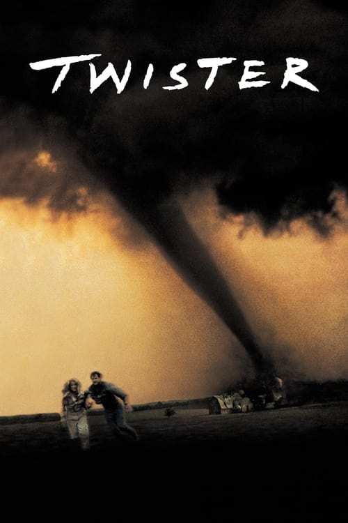
1.”Twister” (1996) – Directed by Jan de Bont and starring Helen Hunt and Bill Paxton, “Twister” is arguably the most iconic storm chasing movie of all time. The film follows a group of storm chasers as they pursue a series of powerful tornadoes across Oklahoma, all while navigating personal relationships and the challenges of their dangerous profession. “Twister” features groundbreaking special effects for its time, and its depiction of storm chasing has inspired countless aspiring meteorologists and storm chasers.
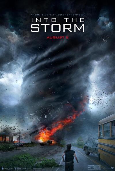
2. “Into the Storm” (2014) – This found-footage style movie follows a group of storm chasers and a high school documentary crew as they encounter a series of devastating tornadoes in the town of Silverton, Oklahoma. “Into the Storm” showcases impressive visual effects and intense action sequences, immersing viewers in the heart of the storm. While the film takes some creative liberties with its portrayal of tornadoes, it still manages to capture the awe-inspiring power and destructive potential of these natural phenomena.
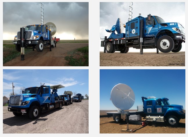
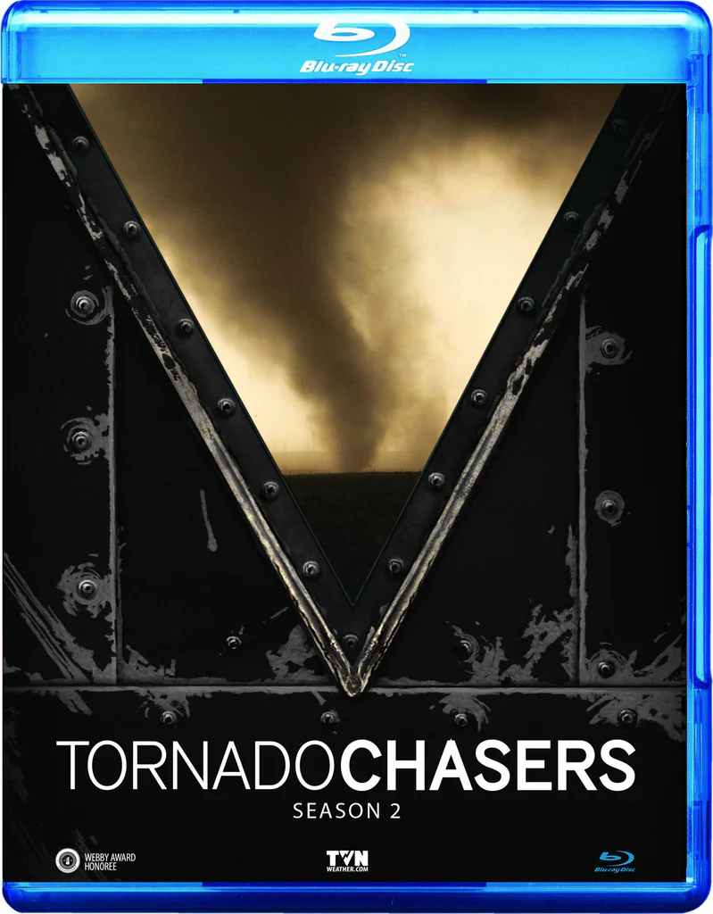
3. “Storm Chasers” (2007-2012) – This Discovery Channel documentary series follows several teams of storm chasers as they pursue tornadoes across the United States. “Storm Chasers” offers a realistic and educational look at the science behind severe weather, as well as the challenges and risks faced by those who study it. The series features renowned storm chasers such as Reed Timmer, Tim Samaras, and Sean Casey, and their cutting-edge research vehicles, including the TIV (Tornado Intercept Vehicle) and the SRV (Dominator).
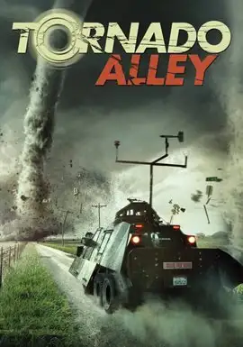
4. “Tornado Alley” (2011) – Directed by Sean Casey, “Tornado Alley” is a documentary film that chronicles the adventures of storm chasers as they attempt to capture footage of tornadoes using the TIV. The film features stunning footage of tornadoes and severe weather, as well as insights into the lives and motivations of storm chasers. “Tornado Alley” also explores the science behind tornadoes and the importance of research in improving our understanding and prediction of these powerful storms.
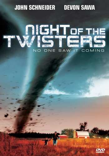
5. “Night of the Twisters” (1996) – Based on the novel by Ivy Ruckman, “Night of the Twisters” is a made-for-TV movie that tells the story of a family’s struggle to survive a devastating tornado outbreak in Nebraska. “Night of the Twisters” also explores the psychological impact of severe weather events on individuals and communities.
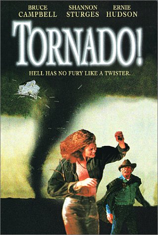
6. “Tornado!” (1996) – Another made-for-TV movie, “Tornado!” follows a storm chaser and a meteorologist as they attempt to warn a small Texas town of an impending tornado. The film features impressive special effects for its time and offers a suspenseful look at the challenges of predicting and responding to severe weather events.
7. “Storm Riders” (2015) – This short-lived TV series follows a group of storm chasers as they pursue tornadoes across the United States. “Storm Riders” offers a behind-the-scenes look at the lives of storm chasers, including the challenges they face both in the field and in their personal lives. The series features stunning footage of tornadoes and severe weather, as well as insights into the science and technology used to study these phenomena.
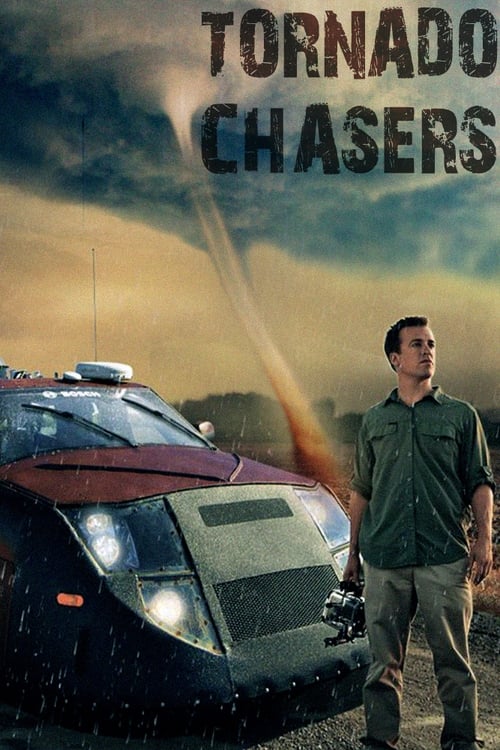
8. “Tornado Chasers” (2012) – This National Geographic documentary follows a team of researchers and storm chasers led by meteorologist Reed Timmer as they attempt to collect data from inside a tornado using their custom-built armored vehicle, the Dominator 2. The documentary offers a fascinating look at the cutting-edge technology and innovative strategies used by storm chasers to study these powerful storms up close.
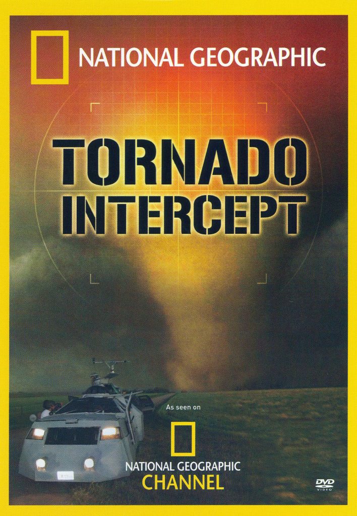
9. “Tornado Intercept” (2005) – Produced by the Discovery Channel, “Tornado Intercept” is a thrilling documentary that follows a team of storm chasers as they pursue tornadoes across the Great Plains. The film features stunning footage of tornadoes and severe weather, as well as insights into the science behind these phenomena and the challenges faced by those who study them.
10. “The Tornado Chasers” (2013) – This BBC documentary series follows a group of storm chasers and meteorologists as they attempt to unravel the mysteries of tornadoes and improve our ability to predict and respond to these devastating storms. “The Tornado Chasers” offers a global perspective on storm chasing.
Classics:
1.”The Wizard of Oz” (1939) – This iconic film features one of the most memorable tornado scenes in cinema history. The movie follows Dorothy Gale as she is transported to the magical land of Oz by a powerful tornado. The tornado scene, with its impressive special effects for the time, has become a classic moment in film history and has inspired countless references and parodies in popular culture.
2. “Cyclone” (1978) – This made-for-TV movie follows a group of people in a small Midwestern town as they struggle to survive a devastating tornado. “Cyclone” was one of the earliest films to focus specifically on tornadoes and their impact on communities. The movie features impressive special effects for its time and offers a suspenseful look at the challenges of predicting and responding to severe weather events.