Mammatus Clouds: Nature’s Breathtaking Spectacle in the Sky

Have you ever gazed up at the sky and witnessed a mesmerizing display of pouches or bubble-like structures hanging from the underside of a cloud? If so, you’ve had the privilege of observing one of nature’s most captivating phenomena: mammatus clouds. These distinctive formations have intrigued scientists, photographers, and cloud enthusiasts alike for centuries, and their appearance never fails to leave observers in awe.

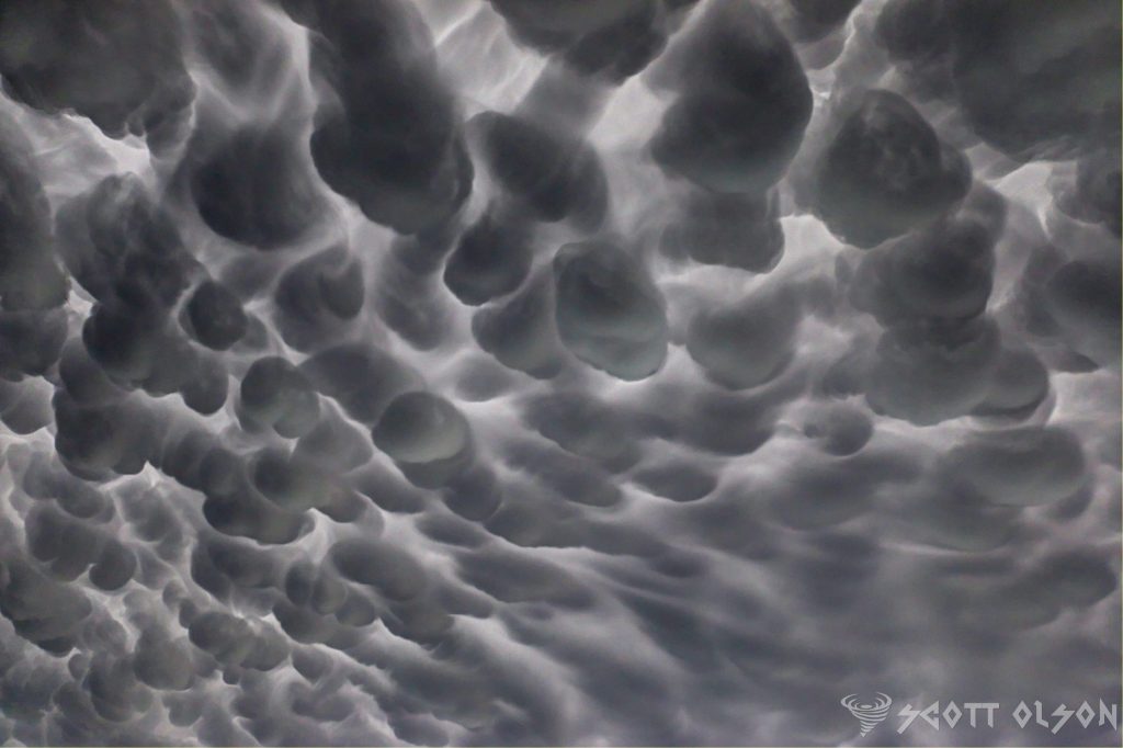
Mammatus clouds, scientifically known as mammatocumulus, are a rare and stunning sight to behold. The term “mammatus” is derived from the Latin word “mamma,” meaning “udder” or “breast,” which aptly describes the appearance of these clouds. They are characterized by their unique pouch-like protrusions that hang down from the base of a cloud, creating a striking visual contrast against the sky.

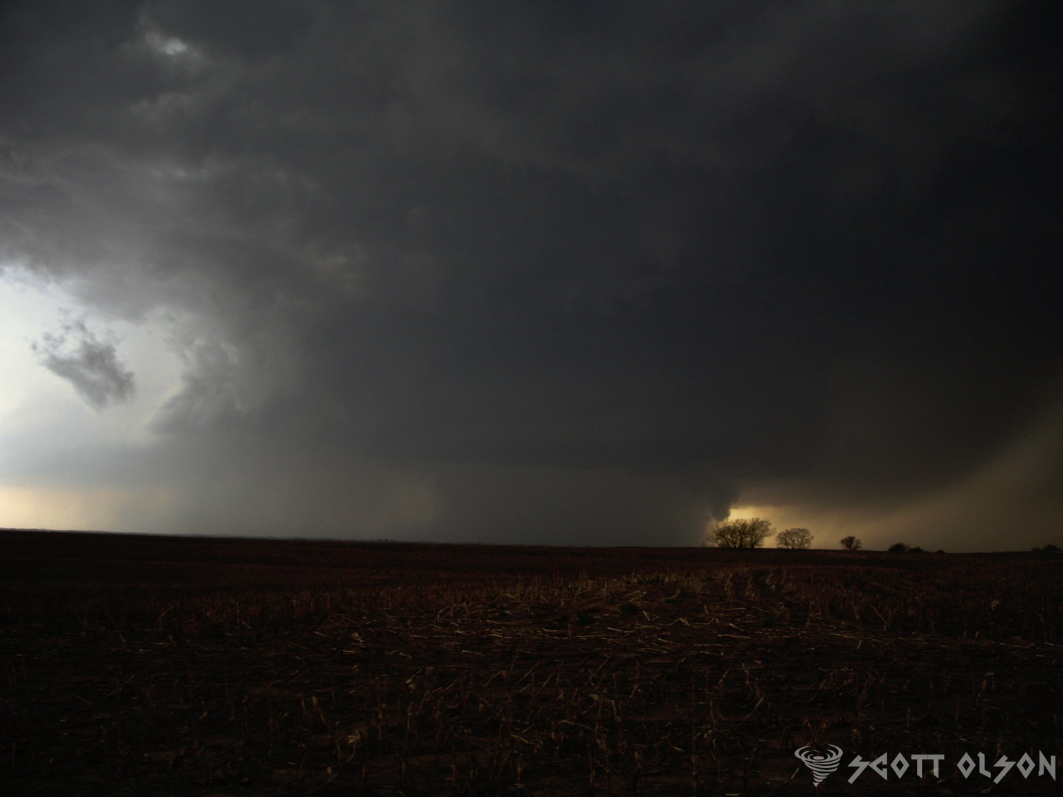
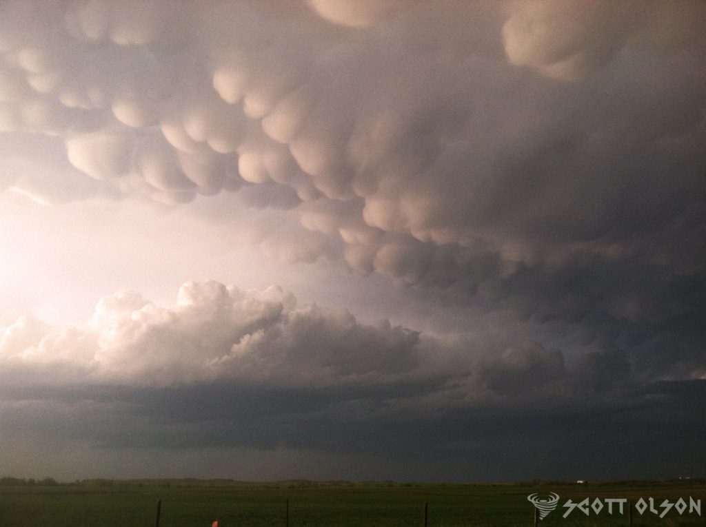
The formation of mammatus clouds is a complex process that involves a combination of atmospheric conditions. These clouds typically occur in association with large cumulonimbus clouds, which are the towering thunderstorm clouds responsible for heavy rainfall, lightning, and even tornadoes. As the cumulonimbus cloud begins to dissipate, the sinking motion of cold air within the cloud can cause the formation of mammatus clouds.

One of the leading theories behind the formation of mammatus clouds suggests that they are the result of a process called “cloud-base detrainment.” This occurs when cold, dense air from the upper parts of the cumulonimbus cloud sinks and pushes into the warmer, more humid air below. As the cold air descends, it creates a series of lobes or pouches that protrude from the bottom of the cloud, giving rise to the distinctive mammatus appearance.

Another factor that contributes to the formation of mammatus clouds is the presence of strong wind shear. Wind shear refers to the change in wind speed or direction with height in the atmosphere. When there is a significant difference in wind speed or direction between the upper and lower levels of a cumulonimbus cloud, it can cause the cloud to become unstable and promote the development of mammatus structures.

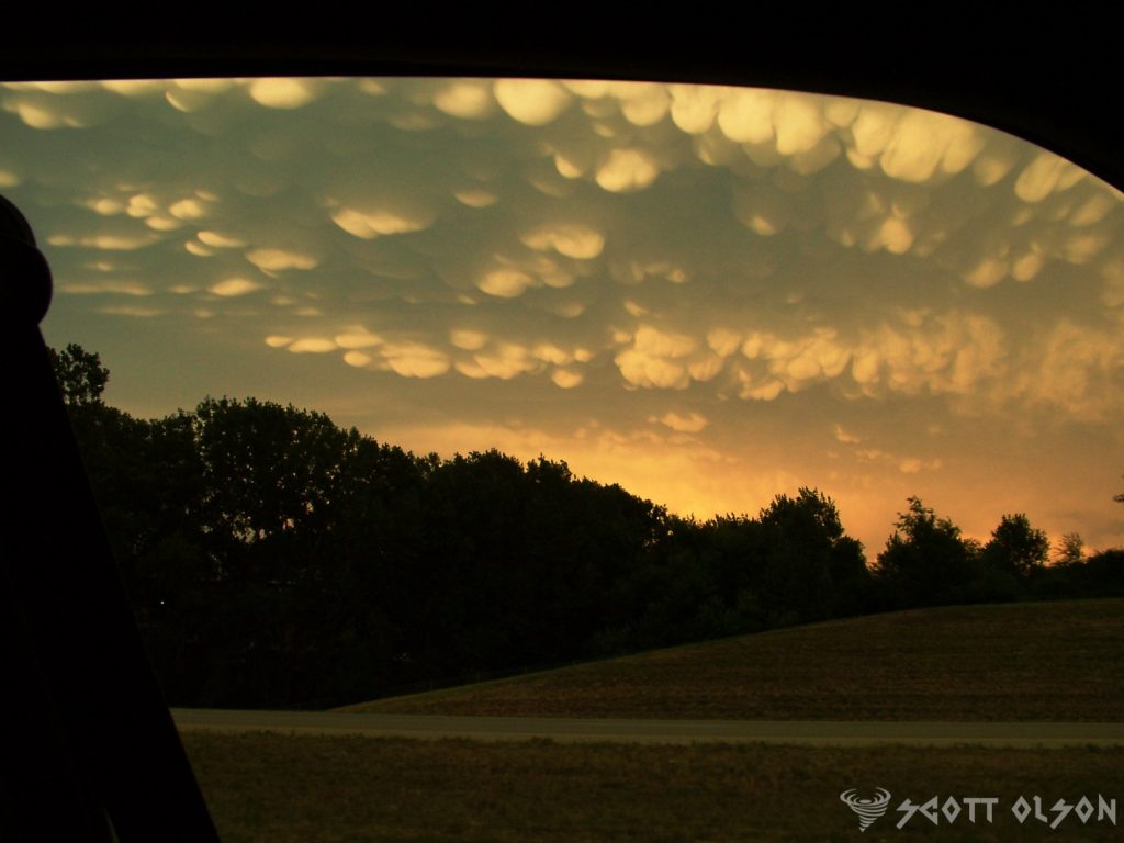
The sight of mammatus clouds is not only visually stunning but also a testament to the incredible forces at work in Earth’s atmosphere. These clouds often appear during severe weather events, such as thunderstorms or even tornadoes, adding an element of drama and intensity to the sky. The pouches can range in size from small, grape-like structures to large, udder-like protrusions that can span several kilometers in length.

Mammatus clouds are not only a treat for the eyes but also a subject of fascination for scientists and researchers. While the exact mechanisms behind their formation are still being studied, these clouds serve as a reminder of the complex and dynamic nature of our atmosphere. They showcase the delicate interplay between temperature, humidity, and wind, resulting in a breathtaking display that captures the imagination of all who witness it.

For photographers and cloud enthusiasts, mammatus clouds present a unique opportunity to capture nature’s artistry at its finest. The contrast between the dark, ominous base of the cumulonimbus cloud and the soft, billowing pouches of the mammatus creates a striking visual composition that is both eerie and beautiful. Many photographers spend hours chasing storms and waiting patiently for the perfect moment to capture these elusive clouds in all their glory.

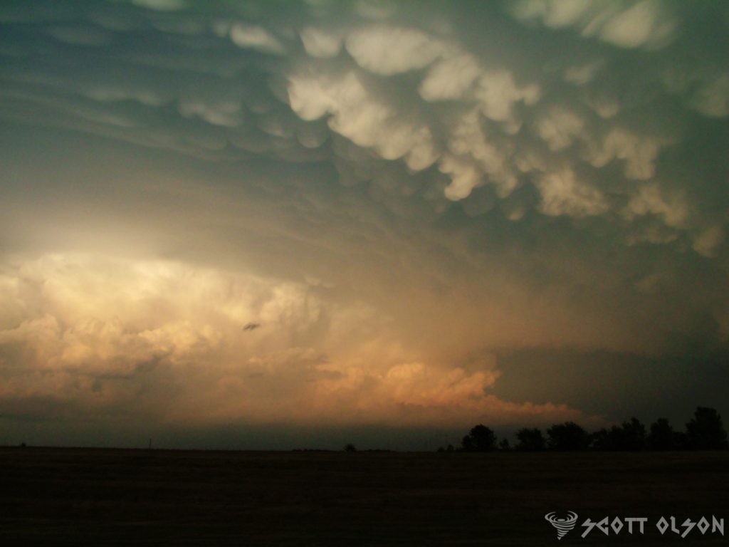
Beyond their aesthetic appeal, mammatus clouds also serve as an important indicator of atmospheric conditions. Their presence often signifies the potential for severe weather, such as strong winds, hail, or even tornadoes. Meteorologists and weather forecasters pay close attention to the development of mammatus clouds, as they can provide valuable insights into the stability of the atmosphere and the likelihood of extreme weather events.

Mammatus clouds are a true marvel of nature, captivating the hearts and minds of people around the world. Their unique appearance, born from the complex interplay of atmospheric conditions, serves as a reminder of the awe-inspiring beauty and power of our planet’s weather systems. Whether you are a scientist, photographer, or simply someone who appreciates the wonders of the natural world, the sight of mammatus clouds is an unforgettable experience that will leave you marveling at the incredible forces at work in the sky above us.

So the next time you find yourself gazing up at a stormy sky, keep an eye out for these mesmerizing pouches of clouds. Take a moment to appreciate the intricate dance of nature’s elements that come together to create such a spectacular display.

Unraveling the Secrets of Severe Weather: The Supercell Composite Parameter and Its Vital Role in Forecasting

In the world of meteorology, forecasting severe weather events is a complex and challenging task. To help predict the likelihood of severe thunderstorms and tornadoes, meteorologists rely on various tools and indices. One such tool is the Supercell Composite Parameter (SCP), a powerful indicator that combines multiple atmospheric variables to assess the potential for supercell thunderstorm development. In this article, we will dive deep into the Supercell Composite Parameter, exploring its components, its significance in severe weather forecasting, and how it helps protect lives and property.

Understanding Supercell Thunderstorms: Before delving into the Supercell Composite Parameter, it’s essential to understand what supercell thunderstorms are and why they are so dangerous. Supercell thunderstorms are highly organized, rotating storms that can produce severe weather hazards such as large hail, damaging winds, and tornadoes. These storms are characterized by a persistent rotating updraft called a mesocyclone, which allows them to maintain their intensity for extended periods. Supercell thunderstorms are responsible for some of the most destructive and deadly severe weather events in history, making their accurate prediction a top priority for meteorologists.

The Components of the Supercell Composite Parameter: The Supercell Composite Parameter is a mathematical formula that combines several key atmospheric variables to assess the potential for supercell thunderstorm development. The main components of the SCP are:

  1. Convective Available Potential Energy (CAPE): CAPE is a measure of the atmospheric instability, representing the amount of energy available for thunderstorm development. Higher CAPE values indicate a greater potential for strong updrafts and severe weather.
  2. Storm-Relative Helicity (SRH): SRH is a measure of the wind shear in the lower atmosphere, which is crucial for the formation of rotating updrafts in supercell thunderstorms. Higher SRH values suggest a greater likelihood of mesocyclone development and tornado potential.
  3. Bulk Wind Difference (BWD): BWD represents the change in wind speed and direction with height, another important factor in supercell development. Strong wind shear, as indicated by high BWD values, helps to create an environment conducive to supercell formation.
  4. Lifting Condensation Level (LCL): The LCL is the height at which air becomes saturated and condensation begins, leading to cloud formation. Lower LCL heights are associated with a greater potential for tornadoes, as they allow for a more concentrated and intense rotation near the ground.

The SCP formula combines these variables in a specific way to create a single value that represents the overall potential for supercell thunderstorm development. Higher SCP values indicate a greater risk of severe weather, particularly supercell thunderstorms and tornadoes.

The Significance of the Supercell Composite Parameter in Severe Weather Forecasting: The Supercell Composite Parameter is a crucial tool for meteorologists in their efforts to predict and warn the public about severe weather events. By analyzing SCP values, forecasters can identify areas where the atmospheric conditions are most favorable for supercell thunderstorm development. This information allows them to issue timely and accurate severe weather watches and warnings, giving people in affected areas the opportunity to take necessary precautions and seek shelter.

One of the key advantages of the SCP is its ability to provide a comprehensive assessment of the severe weather potential. By combining multiple atmospheric variables into a single value, the SCP offers a more holistic view of the overall risk, rather than relying on individual factors alone. This approach helps to reduce the likelihood of false alarms or missed events, improving the overall accuracy and reliability of severe weather forecasts.

Real-World Applications and Success Stories: The Supercell Composite Parameter has proven its value in numerous real-world severe weather events. Meteorologists have successfully used the SCP to anticipate and warn the public about impending supercell thunderstorms and tornadoes, saving countless lives and minimizing property damage.

For example, during the devastating tornado outbreak of April 27, 2011, which affected multiple states in the southeastern United States, the SCP played a crucial role in the forecasting process. Meteorologists recognized the extremely high SCP values across the region, indicating an exceptionally high risk of violent, long-track tornadoes. This information allowed forecasters to issue strongly worded warnings and urge people to take immediate action to protect themselves. While the outbreak still resulted in significant damage and loss of life, the accurate and timely warnings based on the SCP undoubtedly saved many lives.

Similarly, during the May 20, 2013, tornado outbreak in central Oklahoma, the SCP once again demonstrated its value. Forecasters identified the high SCP values in the region, suggesting a significant risk of strong to violent tornadoes. The warnings issued based on this information allowed people to seek shelter and prepare for the impending severe weather. The accurate forecasting and timely warnings were credited with saving numerous lives, even as the powerful tornadoes caused extensive damage.

Limitations and Ongoing Research: While the Supercell Composite Parameter is a valuable tool in severe weather forecasting, it is not without its limitations. The SCP is designed specifically to assess the potential for supercell thunderstorm development and does not account for other types of severe weather, such as non-supercell tornadoes or severe wind events. Additionally, the SCP is based on atmospheric conditions at a specific time and location and may not capture the full evolution of a severe weather event over time.

To address these limitations and further improve severe weather forecasting, ongoing research is focused on refining the SCP and developing new tools and techniques. Meteorologists and atmospheric scientists are working to incorporate additional variables, such as high-resolution radar data and machine learning algorithms, to enhance the accuracy and lead time of severe weather predictions.

One area of active research is the development of probabilistic forecasting methods that provide a range of possible outcomes based on the uncertainty in the atmospheric conditions. By presenting severe weather forecasts in terms of probabilities, meteorologists can better communicate the level of risk to the public and support more informed decision-making.

20 Game-Changing Weather Apps You Can’t Afford to Miss

In today’s world, being prepared for changing weather conditions is crucial. Fortunately, there are numerous weather apps available that can help you stay informed and safe. Here are 20 game-changing weather apps you can’t afford to miss:

  • Dark Sky
    This app is known for its accurate hyperlocal forecasts and beautiful radar maps. It provides down-to-the-minute updates and alerts for precipitation, temperature, and severe weather events, making it a reliable choice for staying on top of changing weather conditions.
  • Hail No
    Defend yourself from hailstorms with Hail No, the first hail app to provide real-time tracking and alert notifications. See where the hail is, create a defensive radius around any location, and get automatic alerts. Hail No provides access to the National Severe Storms Laboratory hail algorithm, the most accurate available, ensuring you’re always aware of potential hail threats.
    Apple: https://apps.apple.com/us/app/hail-no/id1469253867
  • WeatherBug
    WeatherBug is a comprehensive weather app that offers real-time weather data, radar maps, and severe weather alerts. It also includes features like pollen and air quality forecasts, making it a great choice for those with allergies or respiratory issues. Stay informed about changing weather conditions and potential health impacts with WeatherBug.
  • Tornado Vision
    See severe weather with augmented reality! Tornado Vision can help you see tornadoes hiding in the rain or at night. Simply point your phone at any severe storm, and you’ll get a heads-up display on what is happening inside the storm. This groundbreaking weather technology provides information on the chance of a tornado, hail size, wind speed, and more, right on your screen.
    iOS: https://apps.apple.com/us/app/tornado-vision/id1469550036
    Android: https://play.google.com/store/apps/details?id=com.tornadovision.app.presentation&hl=en&gl=US&pli=1
  • RadarScope
    Designed for weather enthusiasts and professionals, RadarScope is a powerful radar app that provides high-resolution radar data, storm tracking, and advanced analysis tools. Dive deep into weather data and gain a comprehensive understanding of weather patterns with this feature-rich app.
  • Predict Now
    Predict Now is a powerful weather app that provides hyperlocal forecasts and real-time alerts for severe weather events. With its user-friendly interface and advanced features, you can stay ahead of the game and plan your activities accordingly, ensuring you’re always prepared for changing weather conditions.
    Apple: https://apps.apple.com/us/app/predict-now/id1481839520
  • NOAA Weather Radar Live
    This free app provides access to real-time weather radar data from the National Oceanic and Atmospheric Administration (NOAA). Stay informed about severe weather events in your area with up-to-date radar information from a trusted source.
  • Weather Underground
    Weather Underground is a comprehensive weather app that offers hyperlocal forecasts, radar maps, and severe weather alerts. It also includes a community feature that allows users to share weather observations and photos, creating a collaborative weather-tracking experience.
  • AccuWeather
    AccuWeather is a popular weather app known for its accurate forecasts and user-friendly interface. It provides detailed weather information, including hourly and daily forecasts, radar maps, and severe weather alerts, ensuring you have all the information you need to plan your day.
  • The Weather Channel
    The Weather Channel app is a reliable source for weather information, offering forecasts, radar maps, and severe weather alerts. It also includes features like hurricane tracking and ski resort conditions, making it a versatile choice for various weather-related activities.
  • Clime: NOAA Weather Radar
    Clime: NOAA Weather Radar is a free app that provides access to real-time weather radar data from NOAA. Stay informed about severe weather events in your area with this simple yet effective app.
  • MyRadar Weather Radar
    MyRadar Weather Radar is a powerful app that offers high-resolution radar data, severe weather alerts, and customizable settings. Tailor the app to your specific needs and get a detailed view of weather conditions in your area.
  • Windy
    Windy is a unique weather app that focuses on wind forecasts and patterns. It provides detailed wind maps, as well as forecasts for temperature, precipitation, and other weather conditions, making it an excellent choice for outdoor enthusiasts and those interested in wind-related activities.
  • Weather Mate
    Weather Mate is a comprehensive weather app that offers hyperlocal forecasts, radar maps, and severe weather alerts. It also includes features like air quality and pollen forecasts, making it a great choice for those with allergies or respiratory issues. Stay informed about weather conditions and potential health impacts with this all-in-one app.
  • Carrot Weather
    Carrot Weather is a unique weather app that combines accurate forecasts with a quirky and humorous personality. It provides detailed weather information, including hourly and daily forecasts, radar maps, and severe weather alerts, all delivered with a touch of humor to make weather tracking more enjoyable.
  • Storm Radar
    Storm Radar is a powerful app that provides real-time radar data, severe weather alerts, and storm tracking capabilities. Stay informed about severe weather events in your area and track storms with this comprehensive app.
  • Weather Live
    Weather Live is a comprehensive weather app that offers hyperlocal forecasts, radar maps, and severe weather alerts. It also includes features like air quality and pollen forecasts, making it a great choice for those with allergies or respiratory issues. Stay informed about weather conditions and potential health impacts with this versatile app.
  • Flowx
    Flowx is a unique weather app that focuses on visualizing weather patterns and forecasts. It provides detailed weather information, including wind patterns, precipitation, and temperature, in a visually stunning format, making it an excellent choice for those who appreciate beautiful data visualization.
  • Weather Maps
    Weather Maps is a powerful app that provides detailed weather maps and forecasts for various weather conditions, including precipitation, temperature, wind, and more. Get a comprehensive view of weather patterns with this data-rich app.
  • Weather Radar by ICM
    Weather Radar by ICM is a free app that provides access to real-time weather radar data from various sources, including NOAA and Environment Canada. Stay informed about severe weather events in your area with this simple yet effective app.

Forecasting Tornadoes and Severe Storms With Modern Technology

Tornadoes, with their raw power and unpredictable nature, have long captivated and terrified people. While the science of forecasting these violent storms has progressed significantly, predicting their exact location and timing remains a complex challenge. However, thanks to advancements in technology, data analysis, and a deeper understanding of atmospheric dynamics, we can now decipher the skies with greater accuracy, providing crucial information to keep communities safe.

The Building Blocks of Severe Weather:

To understand tornado formation, we must first explore the ingredients that brew severe thunderstorms, their birthplace.

  • Instability: The atmosphere needs to be unstable, meaning the air near the ground is warmer and more humid than the air aloft. This temperature difference creates rising air parcels, the building blocks of thunderstorms.
  • Lift: Something needs to initiate the upward movement of air, such as a frontal boundary, a dryline, or even the heating of the ground on a sunny day.
  • Moisture: Ample moisture is necessary to fuel the development of clouds and precipitation within the thunderstorm.
  • Wind Shear: This refers to the change in wind speed and direction with height. Wind shear is crucial for creating rotation within the storm, a key ingredient for tornado formation.

Identifying the Threats:

Meteorologists rely on a variety of tools to identify and track potential severe weather:

  • Doppler Radar: This technology detects precipitation and wind movement within a storm. By analyzing the radar data, meteorologists can identify areas of rotation, known as mesocyclones, which are often precursors to tornadoes. Apps like Tornado Vision utilize radar data to provide users with a visual representation of storm rotation and the potential for tornado development.
  • Satellite Imagery: Satellites provide a broader perspective of weather systems, allowing meteorologists to track storm development, movement, and intensity.
  • Surface Observations: Data from weather stations on the ground, including temperature, humidity, wind speed, and barometric pressure, provide valuable insights into local atmospheric conditions.
  • Weather Models: Complex computer models simulate atmospheric processes to predict future weather conditions. While not perfect, these models have become increasingly sophisticated and provide valuable guidance to forecasters.

Advanced Tools for Enhanced Awareness:

Innovative apps like Predict Now, Hail No!, and Tornado Vision empower individuals with real-time data and storm tracking capabilities:

  • Predict Now: Provides users with comprehensive weather information, including forecasts, radar imagery, and severe weather alerts, allowing them to stay informed about potential threats in their area.
  • Hail No!: Utilizes a specialized hail detection algorithm to display hail locations and sizes in real-time, offering customizable alerts based on hail size and proximity to a user’s location. This app is particularly valuable for individuals in hail-prone areas or those who work outdoors.
  • Tornado Vision: Leverages the power of augmented reality to visualize potential tornadoes within storms. By pointing their phone at a storm, users can see an overlay of data, including the chance of a tornado, hail size, wind speed, and other critical storm characteristics. This innovative technology helps users make informed decisions about their safety during severe weather events.

The Importance of Preparedness:

While forecasting technology continues to improve, tornadoes can still strike with little warning. Preparedness is key to ensuring safety:

  • Stay Informed: Monitor weather forecasts and warnings from reliable sources.
  • Have a Plan: Develop a family emergency plan that includes a designated shelter location, communication protocols, and emergency supplies.
  • Practice Drills: Regularly practice tornado drills so everyone knows what to do and where to go in case of a tornado warning.

By understanding the science behind tornadoes and severe storms, utilizing advanced technology and tools like weather apps, and taking proactive steps toward preparedness, we can better navigate the unpredictable nature of these powerful events and protect ourselves and our communities.

Predict Now – The Ultimate Weather Forecasting App for Enthusiasts

As the creator of Predict Now, I wanted an app that fit the needs of meteorologists, storm chasers, and weather enthusiasts who are passionate about forecasting severe weather. Predict Now is the result of thousands of hours of research, development, and conversations with people who forecast weather.

One of the standout features of Predict Now is its detailed radar maps. I have ensured that the app provides a comprehensive view of radar activity across the entire United States, enabling users to easily track storms and precipitation. Whether you’re monitoring a local thunderstorm or following the path of a hurricane, Predict Now’s radar maps will keep you informed and ahead of the game with updates every 2 minutes.

In addition to radar, I have incorporated a powerful front tracking feature in Predict Now. This allows users to visualize the movement of warm fronts, cold fronts, and other weather systems, providing valuable insights into upcoming changes in the weather pattern. By staying informed about frontal movements, users can make more accurate predictions and better prepare for potential severe weather events.

I am particularly proud of the integration of the Storm Prediction Center’s mesoanalysis tool in Predict Now. This feature grants users access to a wealth of data and visualizations, offering insights into current weather conditions and severe weather potential. Users can explore various indices like CAPE, wind shear, and more, empowering them to make well-informed forecasts and assess the likelihood of severe weather outbreaks.

Predict Now also includes a comprehensive surface observations feature, displaying detailed METARs from numerous locations across different regions, including the infamous Tornado Alley. This allows users to access real-time weather updates and monitor conditions on the ground, which is crucial for storm chasers and those in areas prone to severe weather. There are thousands of surface observations available in Predict Now.

To provide users with the most advanced satellite imagery available, I have integrated data from the cutting-edge GOES-16 satellite into Predict Now. This offers high-resolution visuals of water vapor, infrared, and visible satellite data, giving users a comprehensive understanding of atmospheric conditions. The GOES-16 imagery is a game-changer for weather enthusiasts, enabling them to analyze and predict weather patterns with unprecedented accuracy.

Predict Now also leverages the power of the High-Resolution Rapid Refresh (HRRR) model, which is particularly useful for tracking rapidly changing weather events. The HRRR provides short-term, high-resolution forecasts, allowing users to stay on top of evolving weather situations. Additionally, the app includes other weather models like the NAM and NSSL WRF, offering users a variety of forecasting perspectives to enhance their understanding and prediction capabilities.

I have designed Predict Now with the specific goal of aiding individuals interested in monitoring and preparing for severe weather events like tornadoes, hailstorms, hurricanes and flash floods. The app’s high-resolution data, sourced from advanced models and satellite imagery, ensures accurate and detailed weather visualization. Moreover, Predict Now is optimized for iPhone, providing a smooth and efficient user experience while minimizing data usage.

With its wide coverage spanning the United States and Southern Canada, Predict Now caters to a large user base, making it the go-to app for weather enthusiasts across the region.

I am confident that Predict Now will revolutionize the way you track, analyze, and forecast severe weather. Whether you’re a seasoned meteorologist, a passionate storm chaser, or simply someone who wants to stay informed about the weather, Predict Now is the ultimate tool to elevate your forecasting skills.

Download Predict Now today and join the community of weather enthusiasts who rely on this powerful app to stay one step ahead of the storm. I am committed to continuously improving and updating Predict Now based on user feedback, ensuring that it remains the leading choice for severe weather forecasting.