Understanding Storm Boundaries: Drylines, Warm Fronts, Cold Fronts, and Outflow Boundaries

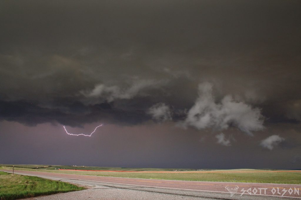
Storms are among the most powerful and awe-inspiring natural phenomena on Earth, capable of producing heavy rain, strong winds, large hail, and even tornadoes. But what causes these storms to form, and what factors influence their severity? The answer lies in the various types of atmospheric boundaries that exist in our atmosphere, including drylines, warm fronts, cold fronts, and outflow boundaries.

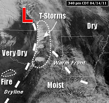
Drylines are a unique type of boundary that is most commonly found in the Great Plains region of the United States. A dryline separates warm, moist air from hot, dry air and is often characterized by a sharp contrast in temperature and humidity across the boundary. As the sun heats the ground during the day, the hot, dry air on one side of the dryline rises, creating a localized area of low pressure. This low-pressure area then draws in the warm, moist air from the other side of the boundary, setting the stage for severe thunderstorm development.

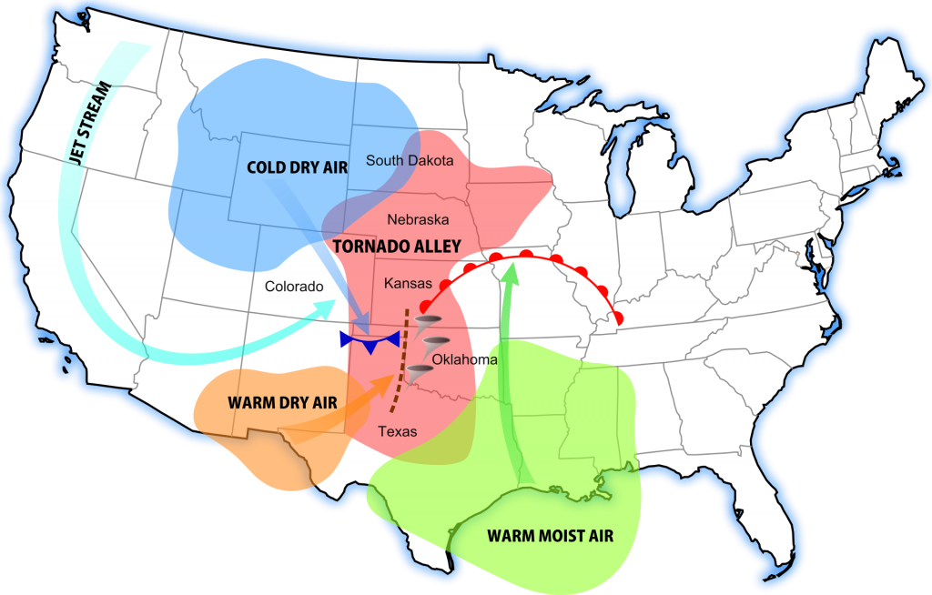
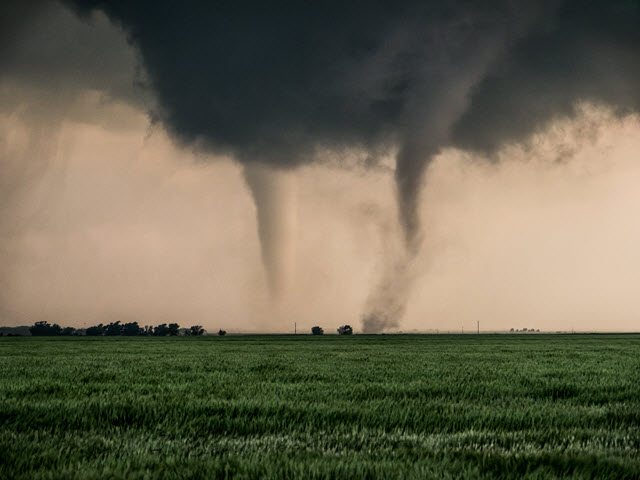
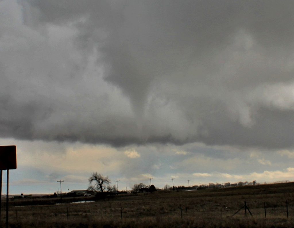
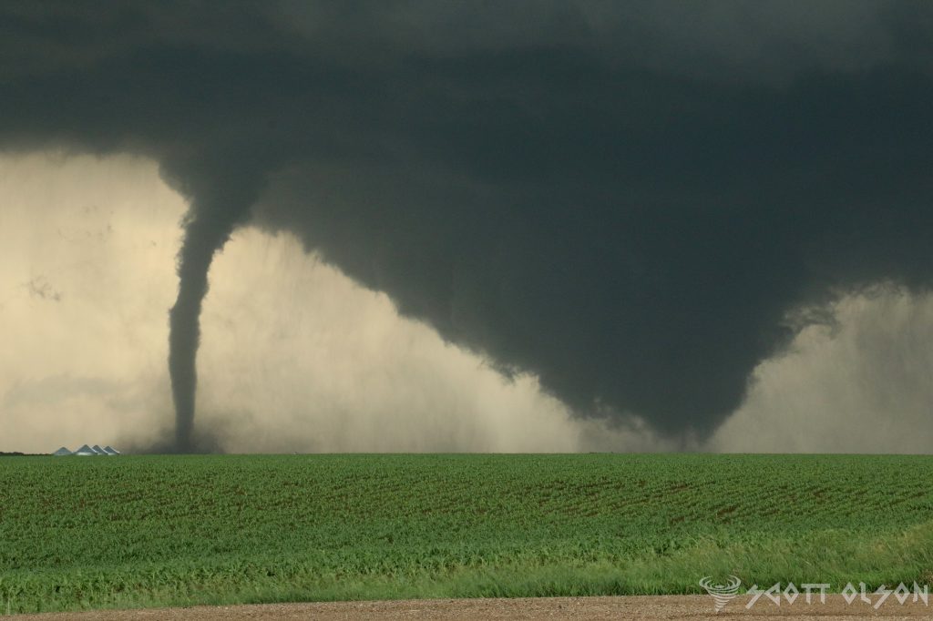
Dryline storms are notorious for their rapid development and intense nature. As the warm, moist air is forced upward by the rising hot, dry air, it cools and condenses, forming towering cumulus clouds that can quickly evolve into severe thunderstorms. These storms often produce large hail, damaging winds, and even tornadoes, making them a significant threat to life and property in the regions where they occur.

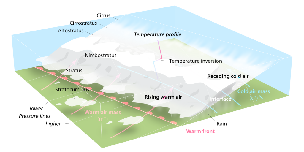
Warm fronts, on the other hand, are a type of boundary that occurs when a mass of warm air advances into a region of cooler air. As the warm air rises over the cooler air, it cools and condenses, forming clouds and precipitation. Warm front storms are generally characterized by widespread cloudiness, steady rain, and occasionally, thunderstorms.

One of the unique features of warm front storms is the gradual nature of their development. Unlike dryline storms, which can form and intensify rapidly, warm front storms tend to develop slowly over a period of several hours or even days. This slow development can lead to prolonged periods of rain and cloudiness, which can have significant impacts on local weather patterns and human activities.

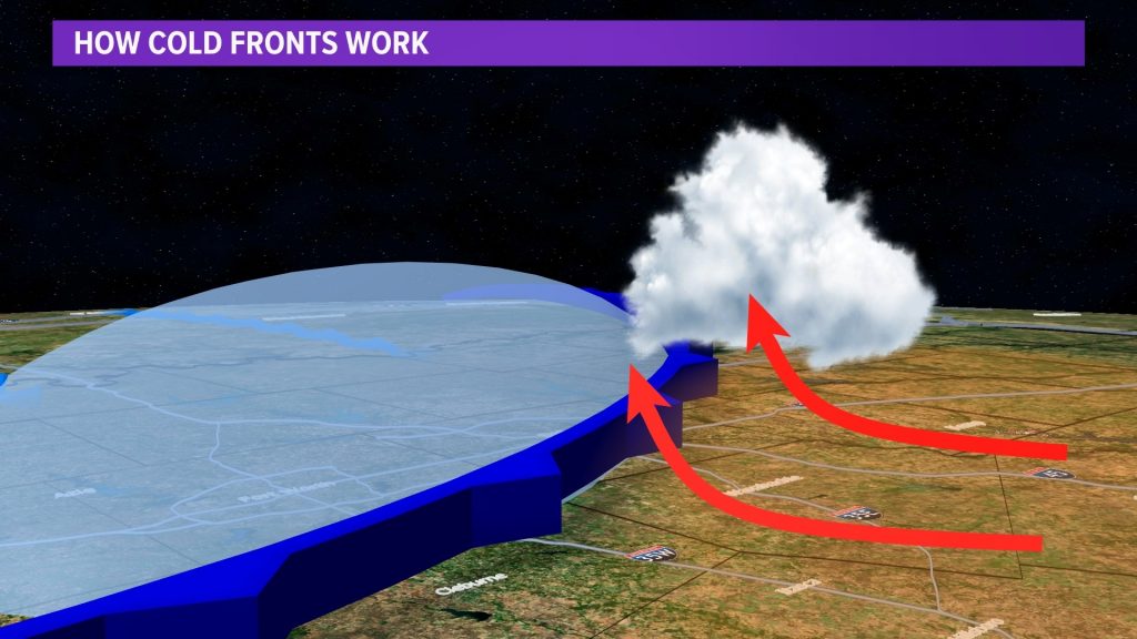
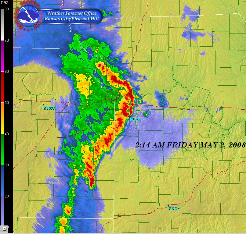
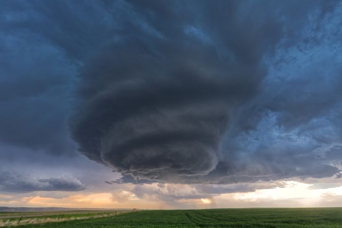
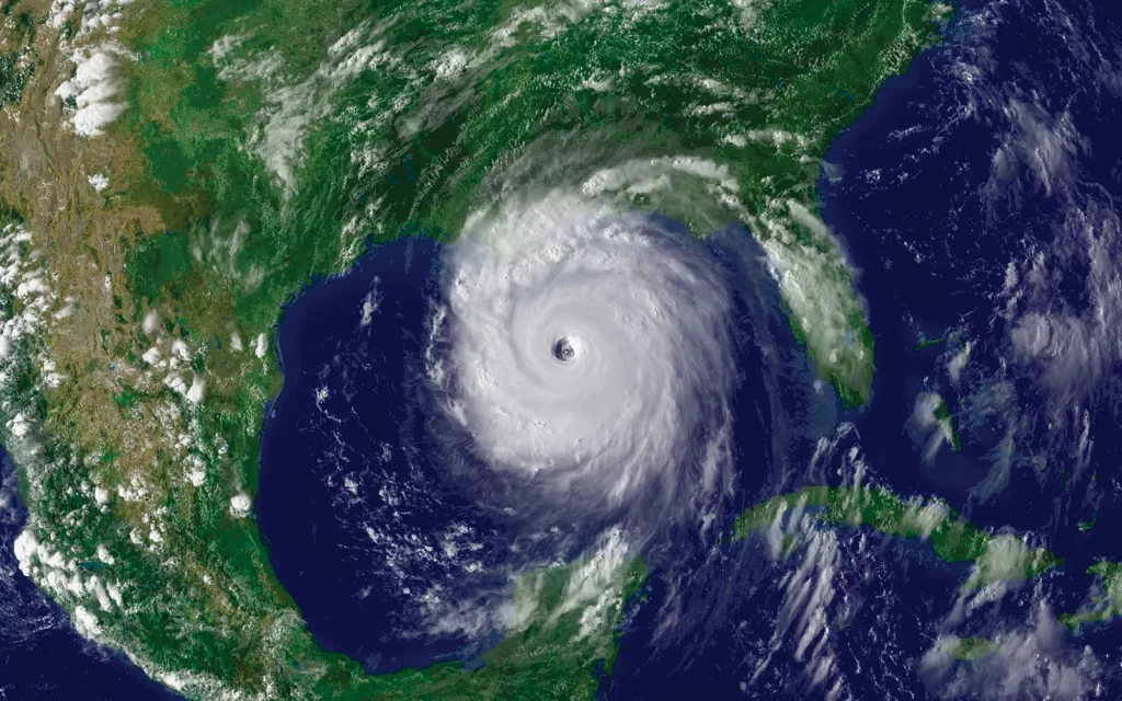
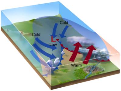
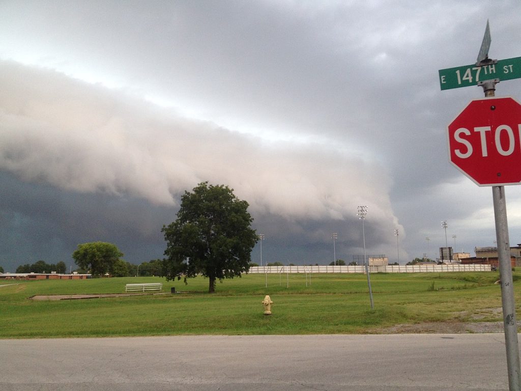
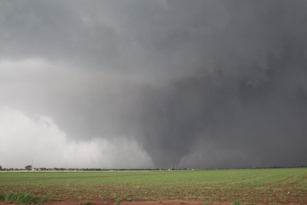
Cold fronts are perhaps the most well-known type of atmospheric boundary, and for a good reason. These boundaries occur when a mass of cold air overtakes a region of warmer air, forcing the warm air to rise rapidly. As the warm air rises, it cools and condenses, forming a line of intense thunderstorms known as a squall line.

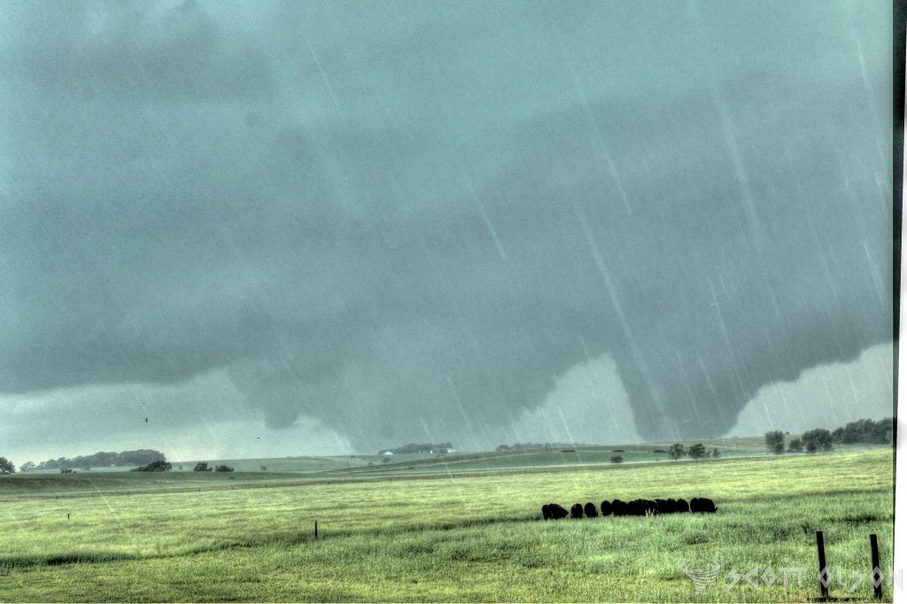
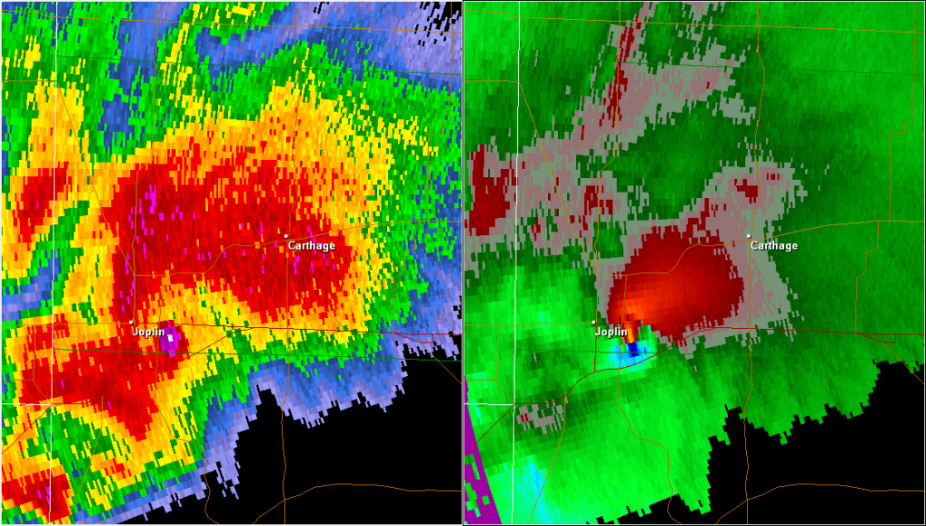
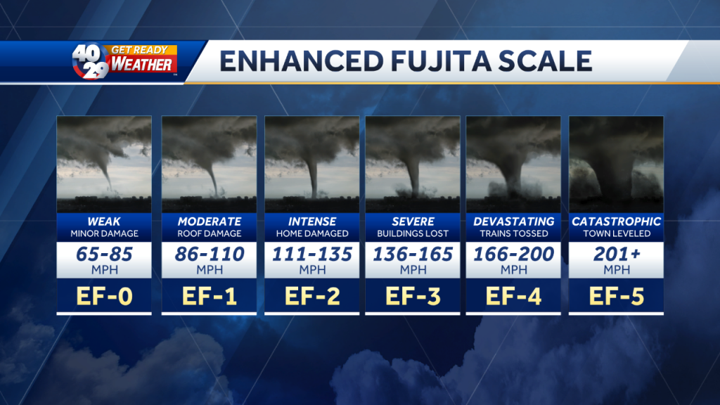
Cold front storms are often accompanied by a dramatic change in weather conditions, with temperatures dropping sharply and winds shifting direction as the front passes through. These storms can produce a wide range of severe weather hazards, including damaging winds, large hail, and tornadoes, making them a significant threat to life and property.

Outflow boundaries are a type of boundary that forms when cool, dense air from a previous storm or rain-cooled air rushes out ahead of the storm, creating a mini cold front. As this cool air undercuts the warm, moist air ahead of it, it can trigger the development of new thunderstorms, often in a repeating cycle known as “training.”

Outflow boundary storms can be particularly dangerous because they can form quickly and with little warning, catching even the most prepared individuals off guard. These storms often produce heavy rain, strong winds, and occasionally, severe weather hazards such as large hail and tornadoes.

While atmospheric boundaries are a critical factor in the formation of severe storms, they are not the only factors at play. Moisture, instability, and wind shear are also essential ingredients in the development of severe thunderstorms and tornadoes. When these factors combine with a strong atmospheric boundary, the result can be a significant severe weather outbreak.

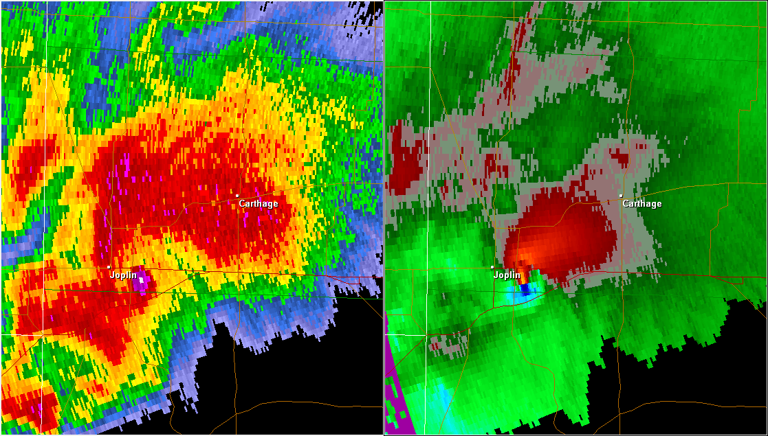
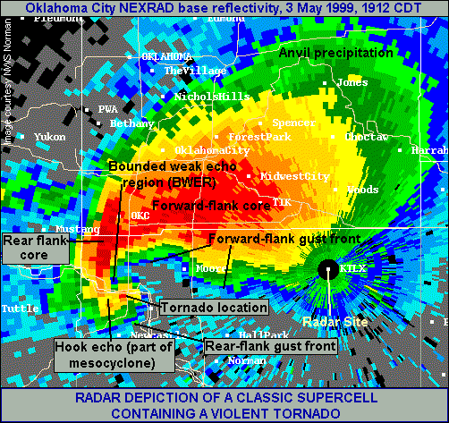
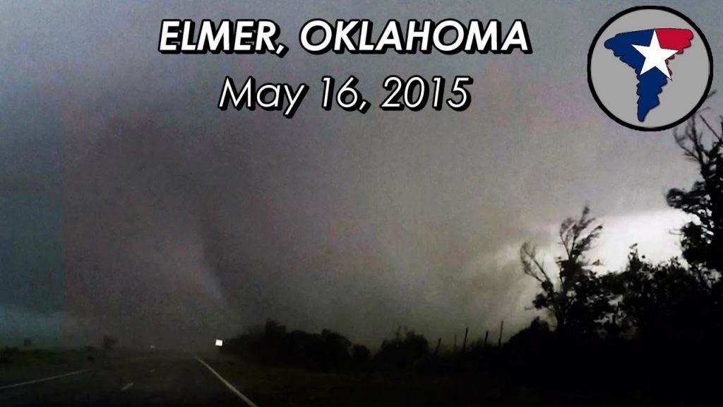
Drylines and Tornadoes: Drylines are known to be a significant factor in the formation of severe thunderstorms and tornadoes, particularly in the Great Plains region of the United States. A study by Hoch and Markowski (2005) found that “70% of all tornadoes in the southern Great Plains from 1999 to 2001 occurred within 100 km of a dryline.”

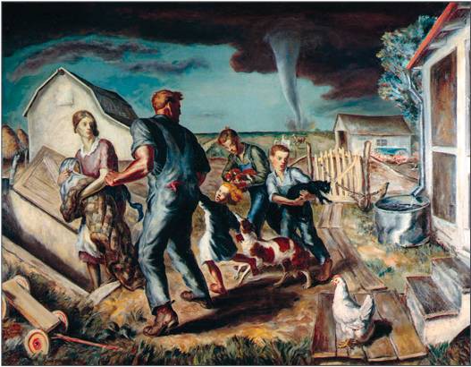
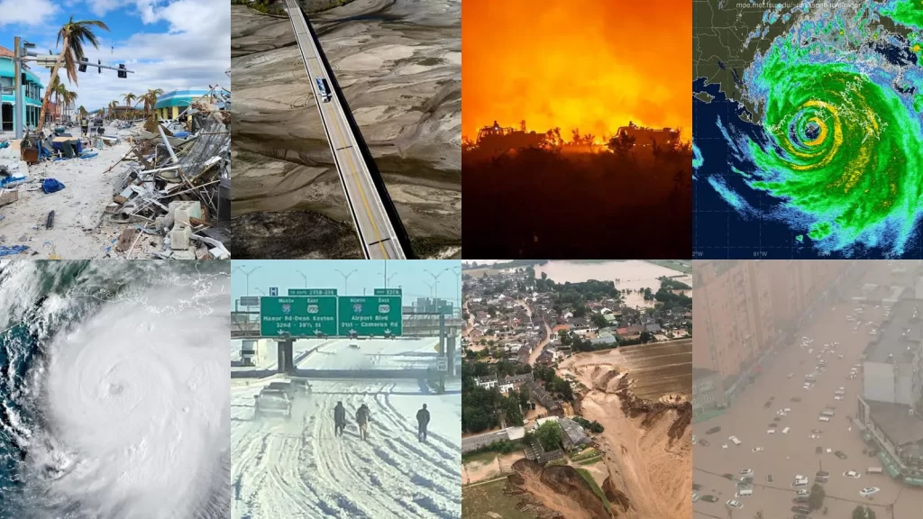
One notable example of a dryline-related tornado outbreak occurred on May 3, 1999, in Oklahoma and Kansas. According to the National Weather Service, this outbreak produced 74 tornadoes, including the devastating F5 tornado that struck Moore, Oklahoma, causing 36 fatalities and over $1 billion in damage.

Warm Fronts and Tornadoes: While warm fronts are less commonly associated with tornado formation than other boundary types, they can still contribute to the development of severe thunderstorms and occasional tornadoes. A study by Gaffin and Parker (2006) found that “approximately 10% of all tornadoes in the United States are associated with warm fronts.”

An example of a warm front-related tornado event occurred on March 2, 2012, in the Ohio Valley region. The National Weather Service reported that an EF4 tornado touched down in Henryville, Indiana, causing significant damage and 11 fatalities. This tornado was associated with a warm front that had been draped across the region, providing the necessary moisture and instability for severe storm development.

Cold Fronts and Tornadoes: Cold fronts are a well-known contributor to severe thunderstorm and tornado formation. A study by Trapp et al. (2005) found that “approximately 60% of all tornadoes in the United States are associated with cold fronts.”

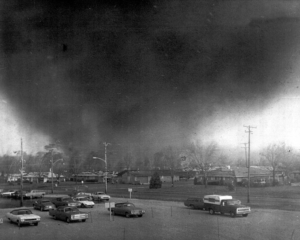
The “Super Outbreak” of April 3-4, 1974, is a prime example of a cold front-related tornado event. During this outbreak, 148 tornadoes touched down across 13 states, causing 330 fatalities and over $600 million in damage (adjusted for inflation). The outbreak was associated with a powerful cold front that swept across the eastern United States, providing the necessary ingredients for widespread severe weather.

Outflow Boundaries and Tornadoes: Outflow boundaries, which are created by the cool, dense air that flows out of thunderstorms, can also contribute to tornado formation. A study by Markowski et al. (1998) found that “nearly 20% of all tornadoes in the central United States are associated with outflow boundaries.”

One example of an outflow boundary-related tornado event occurred on May 20, 2013, in Moore, Oklahoma. On this day, an EF5 tornado touched down, causing 24 fatalities and over $2 billion in damage. The tornado formed along an outflow boundary that had been generated by earlier thunderstorms in the area, highlighting the importance of these boundaries in severe weather formation.

Weather in Art and Literature: How Artists Have Captured the Elements

Throughout history, artists and writers have been captivated by the power and beauty of the weather. From the gentle brush of a summer breeze to the fury of a raging storm, the elements have served as a source of inspiration for countless works of art and literature. In this article, we will explore how artists have captured the essence of weather in their creations and how it has shaped our perception of the natural world.

In the realm of visual arts, weather has been a recurring theme for centuries. One of the earliest examples can be found in the works of the Dutch Golden Age painters of the 17th century. Artists like Jacob van Ruisdael and Aelbert Cuyp were renowned for their landscapes that depicted the changing skies and atmospheric conditions of the Netherlands. Ruisdael’s “The Windmill at Wijk bij Duurstede” (1670) showcases a dramatic sky with billowing clouds and a windmill silhouetted against the light, capturing the essence of the Dutch countryside.

The Romantic era of the late 18th and early 19th centuries saw a surge in the representation of weather in art. Painters like J.M.W. Turner and Caspar David Friedrich were drawn to the sublime and awe-inspiring aspects of nature, often depicting turbulent seas, misty mountains, and stormy skies. Turner’s “Snow Storm: Steam-Boat off a Harbour’s Mouth” (1842) is a prime example of his mastery in conveying the raw power of the elements. The painting depicts a steamboat struggling against the fury of the wind and waves, with the sky and sea merging into a vortex of energy.

In “Tornado over the Wilderness” (1831), American painter Thomas Cole captures the terrifying majesty of a twister tearing through a desolate landscape. The canvas is dominated by the swirling vortex of the tornado, its funnel cloud descending from a dark and ominous sky. The twisted forms of trees and debris caught in the wind’s fury emphasize the destructive power of the storm, while a distant bolt of lightning illuminates the scene with an eerie, otherworldly glow. Cole’s painting serves as a reminder of nature’s untameable force and the insignificance of man in the face of such awesome might, a theme that resonated deeply with the Romantic sensibilities of the time.

In “Cottage Destroyed by Lightning” (1777), English artist Joseph Wright of Derby captures the devastating aftermath of a lightning strike on a rural cottage. The painting is dominated by the shattered ruins of the building, its roof and walls collapsed and smoldering in the wake of the powerful bolt. The dark, turbulent sky above is illuminated by a jagged streak of lightning, casting an eerie, unsettling light across the scene. Wright’s use of dramatic chiaroscuro and his attention to the details of the destruction emphasize the raw, destructive power of nature and the fragility of human life in the face of such overwhelming force.

American painter Martin Johnson Heade’s “Thunderstorm on Narragansett Bay” (1868) depicts a dramatic moment during a powerful coastal storm. The canvas is divided between the dark, roiling clouds above and the choppy, wind-whipped waters below, with a distant shoreline barely visible through the haze. A brilliant flash of lightning illuminates the sky, its jagged bolt reflected in the turbulent waves and casting a stark, almost supernatural light across the scene. Heade’s precise, detailed brushwork and his skillful rendering of the atmospheric effects of the storm create a sense of both awe and unease, capturing the sublime beauty and terror of nature’s fury.

“The Tornado” (1927) by American painter John Steuart Curry. Although Curry was active in the early 20th century, this painting depicts a scene from the previous century. The canvas shows a massive, swirling tornado tearing through a rural landscape, with a farmhouse and barn being ripped apart by the powerful winds. The twister’s funnel cloud is rendered in shades of black and gray, conveying a sense of menace and destruction. In the foreground, a group of figures can be seen seeking shelter, their bodies bent against the force of the wind.

Impressionist painters of the late 19th century were also fascinated by the fleeting effects of light and weather on the landscape. Claude Monet, one of the most prominent figures of the movement, dedicated numerous series to capturing the changing light and atmosphere at different times of the day and in various weather conditions. His “Haystacks” series (1890-1891) depicts the same subject under different light and weather conditions, showcasing how the perception of color and form shifts with the changing elements.

Giorgione’s “The Tempest” (c. 1506-1508) is a masterpiece of Renaissance art that captures the intense drama of a powerful thunderstorm. In this enigmatic painting, a dark and foreboding sky looms over a lush landscape, punctuated by streaks of lightning that illuminate the scene with an eerie glow. The figures in the foreground, a nude woman nursing a child and a soldier standing nearby, appear small and vulnerable against the backdrop of the raging storm, highlighting the awesome power of nature. Giorgione’s use of chiaroscuro, the interplay of light and shadow, adds to the sense of mystery and unease that pervades the painting, inviting the viewer to contemplate the deeper meanings behind this haunting image.

In Rembrandt van Rijn’s “The Storm on the Sea of Galilee” (1633), the Dutch master depicts the biblical story of Jesus calming the storm, capturing the terror and chaos of the moment with his signature mastery of light and shadow. The painting shows the disciples’ boat being tossed about by the turbulent waves, their faces contorted in fear as they struggle against the raging wind and water. Rembrandt’s use of dramatic contrasts, with the dark sky and sea juxtaposed against the bright highlights on the figures and boat, heightens the sense of danger and desperation. The composition draws the viewer’s eye to the figure of Christ, who stands calmly amidst the chaos, his hand raised in a gesture of command, demonstrating his divine power over the elements.

English Romantic painter J.M.W. Turner’s “Snowstorm: Hannibal and his Army Crossing the Alps” (1812) is a powerful example of the artist’s fascination with the sublime forces of nature. The painting depicts the legendary Carthaginian general Hannibal leading his army across the treacherous Alps, battling against a fierce blizzard that threatens to engulf them. Turner’s swirling brushstrokes and pale, almost monochromatic color scheme convey the disorienting fury of the snowstorm, with the tiny figures of Hannibal and his soldiers nearly lost amidst the maelstrom. The painting serves as a testament to the awesome power of nature and the insignificance of human endeavors in the face of such overwhelming might, a central theme of the Romantic movement that Turner helped to define.

In the 20th century, artists continued to explore the theme of weather in their works. American painter Georgia O’Keeffe, known for her abstract depictions of nature, often incorporated elements of the sky and clouds in her paintings. Her “Sky Above Clouds IV” (1965) presents a vast expanse of clouds viewed from above, inviting the viewer to contemplate the immensity and beauty of the atmosphere.

Photography has also played a significant role in capturing the essence of weather. Ansel Adams, one of the most influential photographers of the 20th century, was renowned for his black and white landscapes that often featured dramatic skies and atmospheric conditions. His photograph “Clearing Winter Storm, Yosemite National Park” (1944) depicts the aftermath of a storm, with mist rising from the valley and sunlight breaking through the clouds, creating a sense of tranquility and renewal.

In literature, weather has been used as a powerful tool to set the mood, reflect the emotions of characters, and symbolize deeper themes. Shakespeare frequently employed weather as a metaphor in his plays, with storms and tempests often representing the inner turmoil of his protagonists. In “King Lear,” the raging storm on the heath mirrors the madness and despair of the titular character, while in “The Tempest,” the storm that opens the play serves as a catalyst for the events that unfold.

The Romantic poets of the 19th century, such as William Wordsworth and Percy Bysshe Shelley, often drew inspiration from the natural world and the changing seasons. Wordsworth’s “I Wandered Lonely as a Cloud” (1807) captures the joy and wonder of stumbling upon a field of daffodils on a breezy spring day, while Shelley’s “Ode to the West Wind” (1819) invokes the power of the wind as a force of change and renewal.

In the 20th century, modernist writers like Virginia Woolf and James Joyce used weather to create atmosphere and reflect the inner lives of their characters. In Woolf’s “To the Lighthouse” (1927), the shifting weather patterns at the seaside mirror the changing dynamics of the Ramsay family, while in Joyce’s “Ulysses” (1922), the city of Dublin is brought to life through vivid descriptions of the weather and its effects on the characters’ moods and actions.

Contemporary artists and writers continue to be inspired by the weather and its many manifestations. In the world of installation art, artists like Olafur Eliasson have created immersive environments that simulate natural phenomena, such as his “The Weather Project” (2003) at the Tate Modern, which recreated the experience of a giant sun in the museum’s turbine hall. In literature, authors like Amitav Ghosh have explored the impact of climate change and extreme weather events on human lives and communities, as seen in his novel “The Hungry Tide” (2004), set in the Sundarbans delta of India and Bangladesh.

The representation of weather in art and literature serves as a reminder of our deep connection to the natural world and the power of the elements to shape our experiences and emotions. Whether captured in paint, pixels, or words, the ever-changing face of the weather continues to captivate and inspire artists and writers, inviting us to marvel at the beauty and complexity of the world around us.

From the gentle brush strokes of the Dutch Golden Age painters to the immersive installations of contemporary artists, weather has been a constant presence in the history of art. It has served as a source of inspiration, a metaphor for the human condition, and a reminder of the awesome power of nature. Similarly, in literature, weather has been used to create atmosphere, reflect the inner lives of characters, and explore deeper themes of change, renewal, and the human relationship with the environment.

Is it possible to have two tornadoes at the same time?

Tornadoes are one of the most destructive and fascinating weather phenomena on Earth. These rapidly rotating columns of air can cause significant damage and pose a serious threat to life and property. While most people are familiar with the concept of a single tornado, the question of whether two tornadoes can exist simultaneously is a topic of interest for meteorologists and weather enthusiasts alike. In this article, we will explore the possibility of concurrent tornadoes, focusing on the processes of cyclic tornadogenesis and occluding mesocyclones.

Cyclic Tornadogenesis: Cyclic tornadogenesis is a process by which a supercell thunderstorm produces multiple tornadoes over its lifetime. This phenomenon occurs when a supercell’s mesocyclone (a rotating updraft) undergoes a series of cycles, each producing a new tornado. As the first tornado dissipates, the mesocyclone reorganizes and gives birth to a subsequent tornado. This process can repeat several times, resulting in a series of tornadoes forming from the same parent supercell.

Research has shown that cyclic tornadogenesis is more likely to occur in environments with strong wind shear and high instability. A study by Adlerman and Droegemeier (2005) used high-resolution numerical simulations to investigate the mechanisms behind cyclic mesocyclogenesis. They found that the cycling process is driven by the interaction between the rear-flank downdraft (RFD) and the updraft, which leads to the formation of a new mesocyclone and subsequent tornadogenesis.

Occluding Mesocyclones and Simultaneous Tornadoes: An occluding mesocyclone is a mesocyclone that is in the process of dissipating, often due to the ingestion of cooler, more stable air from the rear-flank downdraft. During this occlusion process, it is possible for the original tornado to still be present while a new mesocyclone and tornado are forming. This scenario can lead to the presence of two simultaneous tornadoes.

On June 16, 2014, the town of Pilger, Nebraska, experienced a rare and devastating tornado event. Two tornadoes, both rated as violent EF-4, touched down simultaneously and caused significant damage to the town. This event is a notable example of simultaneous tornadoes occurring as a result of cyclic tornadogenesis.

The Pilger tornado event was well-documented by storm chasers and researchers, providing valuable data for studying the formation and evolution of these concurrent tornadoes. Wicker et al. (2015) analyzed the event using high-resolution radar data and found evidence of cyclic mesocyclogenesis. The study revealed that the two tornadoes formed from separate mesocyclones within the same supercell thunderstorm, with the second tornado developing as the first one was weakening.

The simultaneous occurrence of the Pilger tornadoes highlights the complexity of cyclic tornadogenesis and the potential for multiple tornadoes to form within a single supercell. This event also emphasizes the importance of advanced radar technology and real-time observations in understanding and forecasting these rare and dangerous phenomena.

Multi-Vortex Tornadoes: Multi-vortex tornadoes are another fascinating aspect of tornado dynamics. These tornadoes are characterized by the presence of multiple smaller vortices rotating around a central axis. While multi-vortex tornadoes are not the same as simultaneous tornadoes, they demonstrate the complex nature of tornado structure and the potential for multiple vortices to exist within a single tornado.

Agee et al. (1977) conducted one of the earliest studies on multi-vortex tornadoes, using photographs and films to analyze the structure and evolution of these tornadoes. They found that multi-vortex tornadoes often exhibit a cyclic behavior, with vortices forming, merging, and dissipating over time. This cyclic nature of multi-vortex tornadoes is similar to the cyclic tornadogenesis process observed in supercell thunderstorms.

More recent studies, such as those by Wurman and Kosiba (2013) and Wakimoto et al. (2016), have used high-resolution mobile Doppler radar data to investigate the dynamics of multi-vortex tornadoes. These studies have revealed the complex interactions between the main vortex and the smaller subvortices, as well as the role of surface friction and debris in modulating the structure and intensity of multi-vortex tornadoes.

The presence of multiple vortices can lead to more erratic and unpredictable tornado paths, as well as localized areas of intense damage. Additionally, the cyclic nature of multi-vortex tornadoes can make it challenging to issue timely and accurate warnings, as the tornado’s intensity and structure can change rapidly.

Unraveling the Mystery: Why Severe Storms Have Green, Teal, and Blue Colors

Supercell thunderstorms are among the most awe-inspiring and powerful weather phenomena on Earth. These storms are characterized by their rotating updrafts, known as mesocyclones, which can produce severe weather conditions such as large hail, damaging winds, and even tornadoes. One of the most striking features of supercells is the occasional appearance of a green or teal color in the sky, particularly near the storm’s base. This unique coloration has fascinated both weather enthusiasts and scientists alike, prompting numerous studies to unravel the mystery behind this phenomenon.

The presence of these large water droplets is crucial to the formation of the green or teal color. Water droplets are particularly effective at absorbing red light, which is at the longer wavelength end of the visible spectrum. As sunlight enters the storm and interacts with these water droplets, a significant portion of the red light is absorbed, leaving the remaining light dominated by shorter wavelengths, which correspond to blue and green colors.

However, the absorption of red light by water droplets alone is not sufficient to explain the intense green or teal hue sometimes observed. Another critical factor is the presence of ice crystals in the upper portions of the storm, particularly in the updraft and the rear flank downdraft (RFD). The RFD is another area of descending air, located on the back side of the storm, often associated with strong winds and large hail.

Ice crystals in the upper portions of the storm can scatter the remaining blue light, further enhancing the green appearance. The combination of red light absorption by water droplets in the lower levels and blue light scattering by ice crystals in the upper levels creates the distinctive green or teal color.

The green coloration is most likely to be observed when the sun is at a low angle on the horizon, typically during the late afternoon or early evening. During this time, sunlight has to travel through more of the Earth’s atmosphere, which can further filter out red light and enhance the green appearance. Additionally, the presence of large amounts of hail in the storm can intensify the green color, as hail can also absorb and scatter light in a manner similar to water droplets and ice crystals. Most storm chasers have experienced the largest hail when storms take on green and teal colors.

It is important to note that not all supercells exhibit a green or teal color, and the absence of this coloration does not necessarily indicate a less severe storm. The appearance of the green hue depends on a delicate balance of factors, including the storm’s structure, the concentration and size of hydrometeors, and the angle of the sun.

While the green or teal color in supercells is a fascinating phenomenon, it is important to remember that it is often associated with the most severe and dangerous storms. Supercells that exhibit this coloration are likely to be producing large hail, damaging winds, and possibly even tornadoes. If you find yourself in the vicinity of a supercell with a green or teal hue, it is crucial to seek shelter immediately and follow the advice of local weather authorities.

Inside the Storm: Decoding Radar’s Secrets – From Bow Echo to Debris Ball

Radar meteorology is one of the most important tools for monitoring and predicting severe weather events. By analyzing radar data, meteorologists can identify specific features that indicate the presence of dangerous storms, such as supercell thunderstorms and tornadoes. In this article, we will discuss some of the most common radar features to look for when assessing severe weather threats.

  1. Hook Echo:
    A hook echo is a distinctive radar signature that often indicates the presence of a supercell thunderstorm capable of producing tornadoes. This feature appears as a hook-shaped appendage extending from the main storm cell on the radar display. The hook shape is formed by the rotation of the storm’s updraft, which can cause rain and hail to wrap around the updraft, creating a hook-like appearance.

    When a hook echo is detected, it is essential to monitor the storm closely, as it has a higher likelihood of producing a tornado. The tightness and persistence of the hook echo can provide clues about the storm’s intensity and potential for tornadogenesis. A tight, well-defined hook echo that persists for an extended period is more likely to be associated with a strong, long-lived tornado.

    1. Bow Echo:
      A bow echo is a radar signature that indicates the presence of a strong, linear wind storm known as a derecho. This feature appears as a bow-shaped line of storms on the radar display, with the apex of the bow pointing in the direction of the storm’s movement. Bow echoes are often associated with widespread damaging winds, which can exceed 100 mph in extreme cases.

    The formation of a bow echo is related to the development of a strong rear-inflow jet behind the main line of storms. This jet of fast-moving air descends to the surface and spreads out, causing the line of storms to bow outward. As the rear-inflow jet continues to strengthen, it can lead to the formation of embedded circulations within the line, known as mesovortices, which can produce brief, spin-up tornadoes.

    1. Debris Ball:
      A debris ball, also known as a tornado debris signature (TDS), is a radar feature that indicates the presence of lofted debris associated with a tornado. This signature appears as a localized area of high reflectivity (bright colors) on the radar display, often coinciding with the location of a hook echo or other tornado-related features.

    The debris ball is caused by the tornado lofting large amounts of debris, such as trees, building materials, and other objects, high into the air. When the radar beam intersects this debris, it produces a strong return signal, which appears as a bright, concentrated area on the radar display. The presence of a debris ball is a strong indication that a tornado is causing damage on the ground.

    1. Three-Body Scatter Spike (TBSS):
      A three-body scatter spike is a radar signature that can indicate the presence of a large hail core within a thunderstorm. This feature appears as a narrow, linear spike of high reflectivity extending radially outward from the storm on the radar display. The TBSS is caused by the radar beam reflecting off a layer of large hailstones and then reflecting again off the ground before returning to the radar.

    The presence of a TBSS suggests that the storm contains a significant amount of large hail, which can cause extensive damage to property and pose a serious risk to public safety. When a TBSS is detected, it is important to issue warnings for large hail and to advise people to seek shelter immediately.

    1. Bounded Weak Echo Region (BWER):
      A bounded weak echo region is a radar feature that indicates the presence of a strong, persistent updraft within a thunderstorm. This feature appears as a localized area of low reflectivity (dark colors) surrounded by higher reflectivity values on the radar display. The BWER is caused by the strong updraft lifting precipitation particles high into the storm, creating a region of relatively low radar returns.

    The presence of a BWER suggests that the storm has a powerful updraft, which can support the formation of large hail and tornadoes. When a BWER is detected, it is important to monitor the storm closely for the development of other severe weather signatures, such as hook echoes or debris balls.

    1. Inflow Notch:
      An inflow notch is a radar signature that indicates the presence of strong, localized inflow into a thunderstorm. This feature appears as a small, localized area of low reflectivity (dark colors) along the leading edge of the storm on the radar display. The inflow notch is caused by the rapid inflow of warm, moist air into the storm, which can fuel the development of strong updrafts and severe weather.

    The presence of an inflow notch suggests that the storm is actively ingesting warm, moist air, which can lead to rapid intensification and the formation of severe weather hazards, such as large hail, damaging winds, and tornadoes. When an inflow notch is detected, it is important to monitor the storm closely for the development of other severe weather signatures.

    1. Rear Inflow Notch (RIN):
      A rear inflow notch is a radar feature that indicates the presence of strong, localized inflow into the back side of a thunderstorm. This feature appears as a small, localized area of low reflectivity (dark colors) along the rear flank of the storm on the radar display. The RIN is caused by the rapid inflow of cooler, drier air into the storm, which can help to strengthen the storm’s updraft and increase the potential for severe weather.

    The presence of a RIN suggests that the storm is actively ingesting cooler, drier air on its back side, which can lead to the formation of a strong rear-flank downdraft (RFD). The RFD can help to tighten the storm’s rotation and increase the risk of tornadogenesis. When a RIN is detected, it is important to monitor the storm closely for the development of hook echoes, debris balls, and other tornado-related signatures.

    1. Hail Spike:
      A hail spike is a radar signature that indicates the presence of a strong updraft capable of producing large hail. This feature appears as a narrow, vertical spike of high reflectivity extending upward from the storm on the radar display. The hail spike is caused by the strong updraft lofting large hailstones high into the storm, where they can grow even larger before falling back to the ground.

    The presence of a hail spike suggests that the storm has a powerful updraft that can support the formation of large, damaging hail. When a hail spike is detected, it is important to issue warnings for large hail and to advise people to seek shelter immediately.

    Advancing Severe Weather Detection: The Rise of Dual Polarization Radar in the US

    Weather radar has always been a cornerstone of meteorological observation and forecasting. Yet, traditional radar systems, while effective, were limited in their ability to decipher the complexities within storms, often leaving meteorologists with an incomplete picture. The advent of dual polarization radar technology marked a paradigm shift, ushering in an era of enhanced precision and understanding in severe weather detection and warnings.

    Understanding the Dual Pol Advantage:

    Traditional weather radars transmit and receive horizontally polarized waves, meaning the waves vibrate parallel to the ground. This provides information about the location and intensity of precipitation but lacks the ability to discern the size, shape, and variety of particles within a storm. Dual polarization technology builds upon this foundation by introducing a second dimension – vertical polarization. By transmitting and receiving both horizontally and vertically polarized waves, dual pol radar paints a more comprehensive picture of the storm environment.

    Transforming Tornado Detection:

    One of the most significant benefits of dual pol technology lies in its ability to enhance tornado detection and warnings. Traditional radar could identify areas of rotation within a storm, suggestive of a possible tornado. However, confirming the presence of a tornado often relied on visual sightings or the detection of debris lofted into the air, both of which could be unreliable or delayed.

    Dual pol radar brought a game-changing advantage: the ability to detect debris fields associated with tornadoes. When a tornado is on the ground, it lifts a variety of objects – from tree limbs and building materials to vehicles and even larger structures. These objects scatter radar waves differently than raindrops or hailstones, creating a distinct signature that dual pol radar can identify. This capability allows meteorologists to confirm the presence of a tornado with greater confidence and issue more timely and accurate warnings, potentially saving lives.

    Sharper Images, Clearer Insights:

    Beyond debris detection, dual pol technology enhances the overall resolution and clarity of radar data. By analyzing the way horizontally and vertically polarized waves interact with precipitation particles, meteorologists can estimate the size and shape of raindrops, hailstones, and snowflakes. This information provides valuable insights into the intensity of precipitation, the potential for flooding, and the type of winter weather expected.

    A Nationwide Upgrade: The Dual Pol Rollout:

    Recognizing the transformative potential of dual polarization technology, the National Weather Service (NWS) embarked on an ambitious endeavor to upgrade its entire network of radars across the United States. The rollout, initiated in 2010 and completed in 2013, involved retrofitting existing radars with dual pol capabilities, ensuring comprehensive coverage for the nation.

    This nationwide upgrade has yielded substantial improvements in severe weather detection and warnings. Studies have shown a significant increase in lead times for tornado warnings and a reduction in false alarms, underscoring the life-saving potential of this technology.

    Beyond Tornadoes: A Multifaceted Tool:

    While the impact of dual pol radar on tornado warnings has been profound, its benefits extend far beyond this realm. The technology has proven invaluable for:

    • Improved Rainfall Estimates: By providing more accurate measurements of rainfall amounts, dual pol data enhances flash flood warnings and supports better water resource management.
    • Winter Weather Monitoring: The ability to differentiate between various types of frozen precipitation, such as snow, sleet, and freezing rain, leads to more precise winter storm forecasts and improved road condition monitoring.
    • Aviation Safety: Dual pol radar aids in identifying hazardous weather phenomena for aviation, including icing conditions and turbulence, contributing to safer air travel.

    The Destructive Power of EF-5 Tornadoes: A Look at the Rarest and Most Devastating Twisters

    The rarity of EF-5 tornadoes can be attributed to the specific atmospheric conditions required for their formation. These conditions include a combination of strong wind shear, instability, and moisture. The presence of a strong, persistent updraft is also crucial in allowing the tornado to maintain its intensity and reach EF-5 status.

    Here are the last five EF-5 tornadoes recorded in the United States:

    1. Moore, Oklahoma (May 20, 2013): This devastating tornado tragically resulted in 24 fatalities and injured 210 people. The estimated population of Moore at the time was around 55,000.
    2. Joplin, Missouri (May 22, 2011): This catastrophic tornado caused immense destruction, claiming the lives of 158 people and injuring over 1,000. Joplin’s population was approximately 50,000 at the time.
    3. Parkersburg, Kansas (May 4, 2007): This powerful tornado resulted in significant damage and tragically took the lives of 11 people. The estimated population of Parkersburg was around 1,400.
    4. Greensburgh, Kansas (May 4, 2007): On the same day as the Parkersburg tornado, Greensburg was struck by another devastating EF5. The town was almost completely destroyed, with 11 fatalities reported. Greensburg’s population was approximately 1,500.
    5. Bridge Creek-Moore, Oklahoma (May 3, 1999): This intense tornado, part of a larger outbreak, caused widespread damage and resulted in 36 fatalities. The combined population of Bridge Creek and Moore was around 41,000 at the time.

    The El Reno tornado is an example of a tornado exhibiting higher wind speeds than those indicated by the damage-based Enhanced Fujita (EF) Scale rating. In fact, there have been several instances where mobile Doppler radar or close-range dual-polarization (dual-pol) radar data have suggested wind speeds exceeding the EF Scale rating.

    For example, the Chickasha, Oklahoma tornado of May 24, 2011, was rated as an EF-4 based on damage surveys. However, mobile Doppler radar data indicated wind speeds of up to 288 mph (463 km/h), which would have classified it as an EF-5. Similarly, the Tipton, Oklahoma tornado of May 16, 2015, was rated as an EF-3, but mobile radar data suggested wind speeds of up to 247 mph (398 km/h), putting it in the EF-5 range.

    These discrepancies between damage-based ratings and radar-measured wind speeds highlight the limitations of the current EF Scale and the need for a more comprehensive approach to tornado intensity classification. By incorporating mobile and close-range dual-pol radar data, scientists and meteorologists could gain a more accurate understanding of a tornado’s true intensity and potential for damage.

    It is worth noting that the Enhanced Fujita (EF) Scale, introduced in 2007, is an updated version of the original Fujita (F) Scale, which was developed by Dr. Theodore Fujita in 1971. The original F Scale was based on the damage caused by tornadoes to structures and vegetation, with ratings ranging from F0 to F5. However, the F Scale had some limitations, such as its subjective nature and the fact that it did not account for differences in building construction and materials.

    The EF Scale was developed to address these limitations and provide a more consistent and objective approach to tornado intensity classification. The EF Scale still uses damage surveys as the primary basis for ratings, but it also takes into account the quality of construction and the types of materials used in structures. Additionally, the wind speed ranges for each EF rating were adjusted based on the latest scientific understanding of the relationship between wind speeds and damage.

    Despite these improvements, the EF Scale still relies heavily on post-event damage surveys, which can be affected by factors such as the availability of damage indicators and the experience of the survey team. Incorporating mobile and close-range dual-pol radar data into the EF Scale could help to overcome these limitations and provide a more comprehensive and accurate assessment of tornado intensity.

    The impact of EF-5 tornadoes on communities is devastating, with long-lasting effects on infrastructure, economy, and the lives of those affected. The high death tolls associated with these tornadoes can be attributed to the extreme wind speeds, the amount of debris generated, and the difficulty in providing adequate warning and shelter.

    Advancements in tornado forecasting and warning systems have helped to reduce the loss of life from EF-5 tornadoes in recent years. However, the destructive power of these rare twisters remains a significant threat to life and property. Continued research into the formation and behavior of EF-5 tornadoes is crucial in improving our understanding and ability to mitigate their impact on communities.

    Reed Timmer: The Story of an Extreme Storm Chaser

    Reed Timmer: The life of a storm chaser

    Reed Timmer is a renowned meteorologist and extreme storm chaser who has dedicated his life to studying and documenting severe weather events. Born on March 17, 1980, in Grand Rapids, Michigan, Timmer developed a fascination with weather at a young age. He pursued his passion by earning a B.S. in Meteorology from the University of Oklahoma in 2002 and later obtained his Ph.D. in Meteorology from the same institution in 2015.

    Timmer’s storm chasing career began in 1999 when he joined the University of Oklahoma’s storm chasing team. He quickly gained notoriety for his fearless approach to intercepting tornadoes and hurricanes, often placing himself in harm’s way to gather valuable data and capture stunning footage.

    Timmer’s research focuses on collecting valuable data from within the heart of severe storms using state-of-the-art instruments, such as mobile tornado probes. By gathering this data, he has helped improve tornado forecasting and warning systems, ultimately saving lives and property. His innovative approach to storm chasing led him to design and build a series of armored vehicles called “Dominators,” which allow him and his team to safely navigate through the most intense weather conditions.

    In addition to his scientific contributions, Timmer has played a significant role in educating the public about severe weather and storm safety. He has been featured in numerous television shows and documentaries, including “Storm Chasers” on the Discovery Channel and “Extreme Weather” on National Geographic. These appearances have helped raise awareness about the dangers of severe weather and the importance of being prepared.

    Timmer’s commitment to education extends beyond the media. He frequently gives presentations at schools, universities, and community events, sharing his knowledge and experiences with audiences of all ages. His engaging and informative talks inspire future generations of meteorologists and emphasize the critical role that storm safety plays in protecting communities.

    Beyond his research and educational efforts, Timmer has also ventured into entrepreneurship. He founded TVN Weather, a company that provides live severe weather video content to media outlets, allowing viewers to witness the power and beauty of extreme weather events from the safety of their homes. Additionally, he established SRV Dominator, which offers storm chasing tours and experiences to the public, giving individuals a unique opportunity to learn about severe weather firsthand.

    In 2008, Timmer became a featured meteorologist on the Discovery Channel’s reality television series “Storm Chasers.” The show followed Timmer and his team as they pursued severe weather events across the United States. During his time on the show, Timmer showcased his expertise and innovative storm chasing techniques, including the use of armored vehicles like the “Dominator” to safely navigate through dangerous conditions.

    Throughout his career, Timmer has witnessed and documented over 1,000 tornadoes and numerous hurricanes, including Hurricane Katrina in 2005 and Hurricane Harvey in 2017. His up-close footage of these powerful storms has provided valuable insights for the scientific community and has helped raise public awareness about the dangers of severe weather.

    In addition to his storm chasing endeavors, Timmer is also an accomplished researcher. His doctoral thesis focused on the study of tornadoes and their environments using high-resolution radar data. Timmer’s research has contributed to a better understanding of tornado formation and has the potential to improve tornado warning systems.

    As an educator, Timmer has taught meteorology courses at the University of Oklahoma and has been a guest lecturer at numerous universities and conferences worldwide. He is also the author of the book “Into the Storm: Violent Tornadoes, Killer Hurricanes, and Death-Defying Adventures in Extreme Weather,” which chronicles his experiences as a storm chaser and meteorologist.

    Reed Timmer’s dedication to studying and documenting severe weather events has made him one of the most respected and well-known figures in the field of meteorology. His work has not only advanced our understanding of these powerful natural phenomena but has also helped to save lives by providing valuable information to the public and emergency management officials.

    20 Game-Changing Weather Apps You Can’t Afford to Miss

    In today’s world, being prepared for changing weather conditions is crucial. Fortunately, there are numerous weather apps available that can help you stay informed and safe. Here are 20 game-changing weather apps you can’t afford to miss:

    Dark Sky
    This app is known for its accurate hyperlocal forecasts and beautiful radar maps. It provides down-to-the-minute updates and alerts for precipitation, temperature, and severe weather events, making it a reliable choice for staying on top of changing weather conditions.

    Hail No
    Defend yourself from hailstorms with Hail No, the first hail app to provide real-time tracking and alert notifications. See where the hail is, create a defensive radius around any location, and get automatic alerts. Hail No provides access to the National Severe Storms Laboratory hail algorithm, the most accurate available,
    ensuring you’re always aware of potential hail threats.
    Apple: https://apps.apple.com/us/app/hail-no/id1469253867

    WeatherBug
    WeatherBug is a comprehensive weather app that offers real-time weather data, radar maps, and severe weather alerts. It also includes features like pollen and air quality forecasts, making it a great choice for those with allergies or respiratory issues. Stay informed about changing weather conditions and potential health impacts with WeatherBug.

    Tornado Vision
    See severe weather with augmented reality! Tornado Vision can help you see tornadoes hiding in the rain or at night. Simply point your phone at any severe storm, and you’ll get a heads-up display on what is happening inside the storm. This groundbreaking weather technology provides information on the chance of a tornado, hail size, wind speed, and more, right on your screen.
    iOS: https://apps.apple.com/us/app/tornado-vision/id1469550036
    Android: https://play.google.com/store/apps/details?id=com.tornadovision.app.presentation&hl=en&gl=US&pli=1

    RadarScope
    Designed for weather enthusiasts and professionals, RadarScope is a powerful radar app that provides high-resolution radar data, storm tracking, and advanced analysis tools. Dive deep into weather data and gain a comprehensive understanding of weather patterns with this feature-rich app.

    Predict Now
    Predict Now is a powerful weather app that provides hyperlocal forecasts and real-time alerts for severe weather events. With its user-friendly interface and advanced features, you can stay ahead of the game and plan your activities accordingly, ensuring you’re always prepared for changing weather conditions.
    Apple: https://apps.apple.com/us/app/predict-now/id1481839520

    NOAA Weather Radar Live
    This free app provides access to real-time weather radar data from the National Oceanic and Atmospheric Administration (NOAA). Stay informed about severe weather events in your area with up-to-date radar information from a trusted source.

    Weather Underground
    Weather Underground is a comprehensive weather app that offers hyperlocal forecasts, radar maps, and severe weather alerts. It also includes a community feature that allows users to share weather observations and photos, creating a collaborative weather-tracking experience.

    AccuWeather
    AccuWeather is a popular weather app known for its accurate forecasts and user-friendly interface. It provides detailed weather information, including hourly and daily forecasts, radar maps, and severe weather alerts, ensuring you have all the information you need to plan your day.

    The Weather Channel
    The Weather Channel app is a reliable source for weather information, offering forecasts, radar maps, and severe weather alerts. It also includes features like hurricane tracking and ski resort conditions, making it a versatile choice for various weather-related activities.

    Clime: NOAA Weather Radar
    Clime: NOAA Weather Radar is a free app that provides access to real-time weather radar data from NOAA. Stay informed about severe weather events in your area with this simple yet effective app.

    MyRadar Weather Radar
    MyRadar Weather Radar is a powerful app that offers high-resolution radar data, severe weather alerts, and customizable settings. Tailor the app to your specific needs and get a detailed view of weather conditions in your area.

    Windy
    Windy is a unique weather app that focuses on wind forecasts and patterns. It provides detailed wind maps, as well as forecasts for temperature, precipitation, and other weather conditions, making it an excellent choice for outdoor enthusiasts and those interested in wind-related activities.

    Weather Mate
    Weather Mate is a comprehensive weather app that offers hyperlocal forecasts, radar maps, and severe weather alerts. It also includes features like air quality and pollen forecasts, making it a great choice for those with allergies or respiratory issues. Stay informed about weather conditions and potential health impacts with this all-in-one app.

    Carrot Weather
    Carrot Weather is a unique weather app that combines accurate forecasts with a quirky and humorous personality. It provides detailed weather information, including hourly and daily forecasts, radar maps, and severe weather alerts, all delivered with a touch of humor to make weather tracking more enjoyable.

    Storm Radar
    Storm Radar is a powerful app that provides real-time radar data, severe weather alerts, and storm tracking capabilities. Stay informed about severe weather events in your area and track storms with this comprehensive app.

    Weather Live
    Weather Live is a comprehensive weather app that offers hyperlocal forecasts, radar maps, and severe weather alerts. It also includes features like air quality and pollen forecasts, making it a great choice for those with allergies or respiratory issues. Stay informed about weather conditions and potential health impacts with this versatile app.

    Flowx
    Flowx is a unique weather app that focuses on visualizing weather patterns and forecasts. It provides detailed weather information, including wind patterns, precipitation, and temperature, in a visually stunning format, making it an excellent choice for those who appreciate beautiful data visualization.

    Weather Maps
    Weather Maps is a powerful app that provides detailed weather maps and forecasts for various weather conditions, including precipitation, temperature, wind, and more. Get a comprehensive view of weather patterns with this data-rich app.

    Weather Radar by ICM
    Weather Radar by ICM is a free app that provides access to real-time weather radar data from various sources, including NOAA and Environment Canada. Stay informed about severe weather events in your area with this simple yet effective app.