Hurricane Katrina: The Destruction of New Orleans

The date August 29, 2005, remains etched in the annals of American history, a day when Hurricane Katrina, a tempest of unimaginable fury, unleashed its wrath upon the Gulf Coast. New Orleans, a city celebrated for its vibrant culture, rich history, and unique spirit, found itself at the epicenter of the disaster. As Katrina’s winds howled and storm surge swelled, the city’s levee system, a supposed bulwark against the encroaching waters, failed catastrophically.

Meteorological Timeline:
  • August 23, 2005: A tropical depression forms over the Bahamas, later strengthening into Tropical Storm Katrina.
  • August 25, 2005: Katrina intensifies into a Category 1 hurricane and makes landfall in southern Florida, causing flooding and wind damage.
  • August 26-27, 2005: Katrina emerges into the Gulf of Mexico and undergoes rapid intensification, reaching Category 5 strength with sustained winds of 160 mph.
  • August 28, 2005: Katrina weakens slightly to a Category 3 hurricane but remains a formidable storm as it approaches the Gulf Coast.

Landfall and Immediate Aftermath:

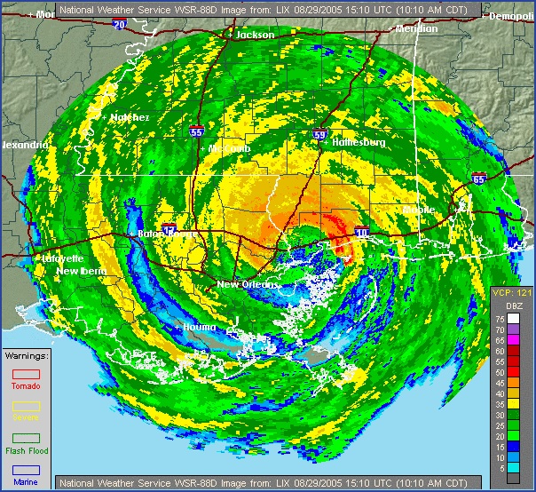
  • August 29, 2005: Hurricane Katrina makes landfall near Buras-Triumph, Louisiana, as a Category 3 hurricane with sustained winds of 125 mph. The storm surge, exceeding 20 feet in some areas, breaches levees in New Orleans, leading to catastrophic flooding.
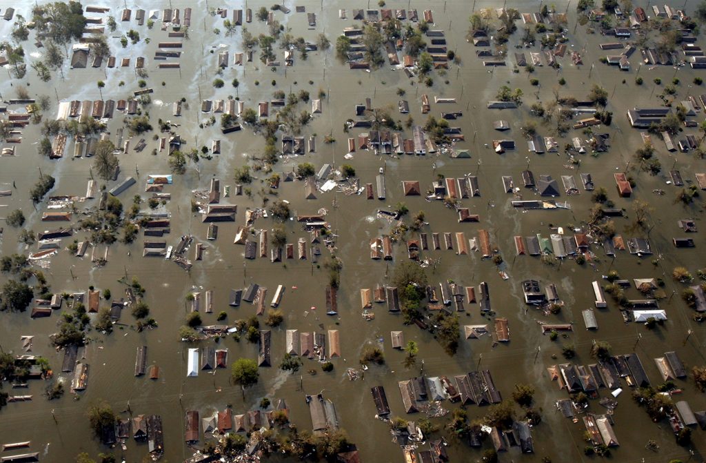
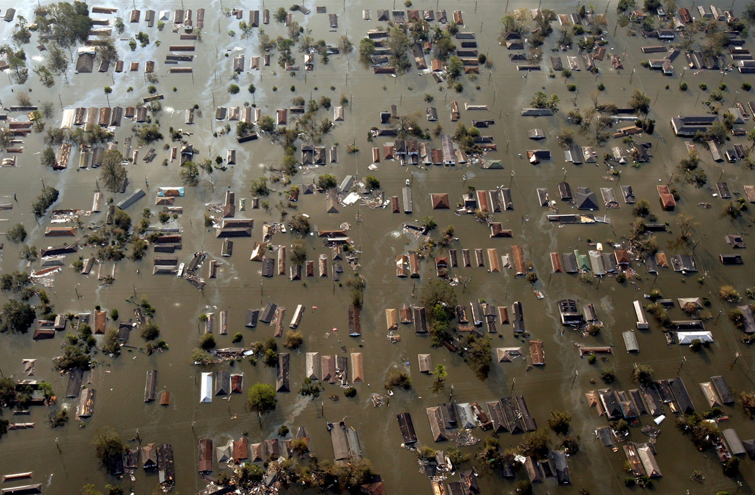
  • August 29-30, 2005: Floodwaters inundate New Orleans, submerging entire neighborhoods and stranding residents. The Superdome, serving as a shelter, becomes overcrowded and conditions deteriorate. Rescue efforts begin, but the scale of the disaster overwhelms response capabilities.

Unfolding Disaster and Response Efforts:

  • August 31 – September 4, 2005: The magnitude of the disaster becomes increasingly apparent as floodwaters remain stagnant and rescue efforts continue. The Lower Ninth Ward and other low-lying areas of New Orleans remain submerged, with residents trapped and desperate for help. Criticism mounts over the slow and inadequate response from federal, state, and local authorities.
  • September 5-10, 2005: Floodwaters begin to recede slowly, revealing the extent of the devastation. Search and rescue efforts transition to recovery operations, as debris removal and damage assessments begin. The death toll rises, and the displacement of hundreds of thousands of residents creates a humanitarian crisis.

The consequences were immediate and devastating. Floodwaters surged through breaches in the levees, transforming streets into raging rivers and submerging entire neighborhoods. The iconic French Quarter, with its historic architecture and lively atmosphere, became an island amidst a sea of brown, polluted water. The Superdome, a massive stadium that had served as a shelter of last resort for thousands of evacuees, became a symbol of the city’s plight, its roof peeled back and its interior conditions deteriorating rapidly.

Across the city, tales of survival and heartbreak unfolded. Residents trapped in attics and on rooftops awaited rescue, desperate for any sign of help. Families were separated, loved ones lost, and homes destroyed. The Lower Ninth Ward, a predominantly African American neighborhood, suffered some of the worst flooding, its residents left stranded and forgotten for days. The stories that emerged from Katrina’s aftermath were a testament to the human spirit’s resilience in the face of unimaginable adversity.

Katrina’s impact extended far beyond New Orleans. Coastal communities across Mississippi, Alabama, and the Florida Panhandle were battered by the storm’s fury. In Biloxi, Mississippi, a once-thriving tourist destination, the storm surge swept away homes, businesses, and casinos, leaving behind a desolate landscape of debris and destruction. Gulfport, Mississippi, another coastal city, faced similar devastation, its harbor and waterfront areas obliterated by the storm’s power.
As Katrina moved inland, it weakened but continued to unleash torrential rains, leading to widespread flooding across the Southeast. Rivers and streams overflowed their banks, inundating homes and businesses and displacing thousands. The storm’s impact on infrastructure was equally devastating, with power outages affecting millions and transportation networks crippled. The economic toll of Katrina was staggering, estimated at over $100 billion, making it one of the costliest natural disasters in U.S. history.

The meteorological factors that contributed to Katrina’s formation and intensification were a perfect storm of conditions. Warm waters in the Gulf of Mexico provided ample fuel for the storm’s growth, while low wind shear allowed it to maintain its structure and strengthen rapidly. A high-pressure system over the southeastern United States steered Katrina on a direct path towards the Gulf Coast, giving residents little time to prepare for the impending disaster.

Katrina’s legacy is complex and multifaceted. The storm exposed deep-seated social and economic inequalities, as marginalized communities disproportionately bore the brunt of the disaster. The failure of the levee system in New Orleans raised questions about infrastructure investment and disaster preparedness, prompting a national conversation about the nation’s vulnerability to extreme weather events. The storm’s aftermath was marked by a slow and often chaotic response, leading to criticism of government agencies at all levels and calls for reform.

Hurricane Katrina serves as a stark reminder of the destructive power of nature and the importance of preparedness, infrastructure investment, and social equity in mitigating the impact of such catastrophic events. The storm’s legacy continues to shape policy and planning, as communities strive to build resilience and ensure that the lessons learned from Katrina are not forgotten. The stories of survival, loss, and community spirit that emerged from the storm’s aftermath continue to inspire and remind us of the indomitable human spirit in the face of adversity.
Hurricane Laura’s Wrath: A Catastrophic Landfall in Louisiana (August 27, 2020)

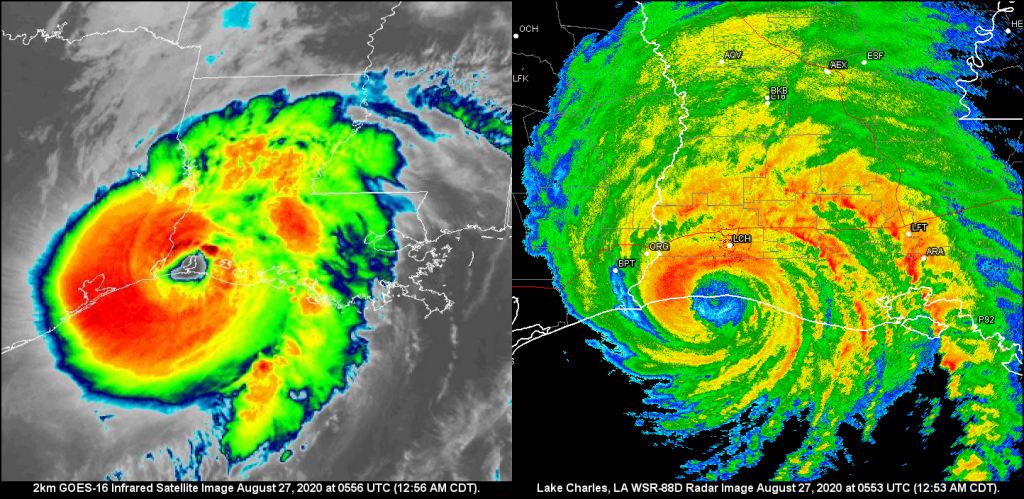
The morning of August 27, 2020, dawned with a sense of foreboding for residents of southwestern Louisiana and southeastern Texas. Hurricane Laura, a formidable Category 4 storm with sustained winds of 150 mph, was churning in the Gulf of Mexico, its sights set on the coastline. This wasn’t just another storm; Laura was poised to become one of the most powerful hurricanes to ever strike the region, leaving an indelible mark on the landscape and its people.

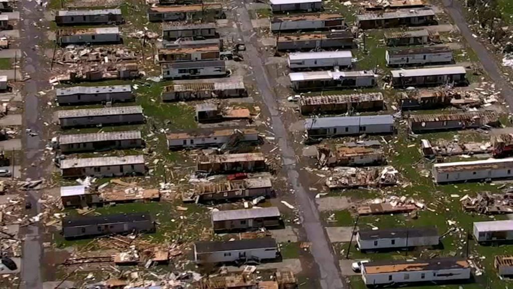
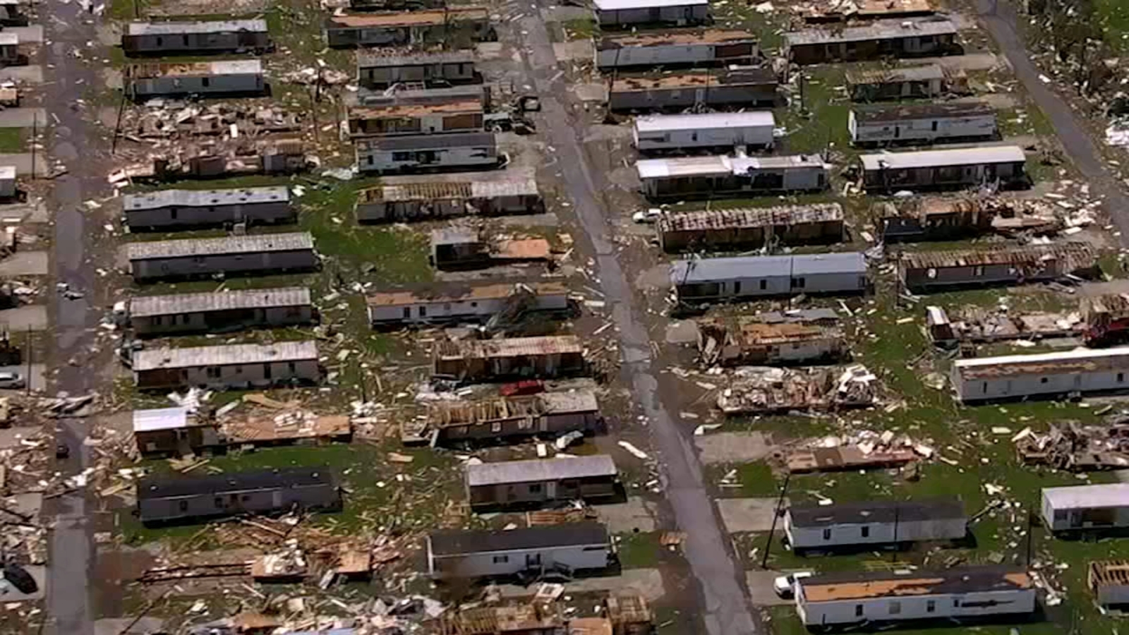
Landfall occurred around 1 am near Cameron, Louisiana, a small community southwest of Lake Charles. The storm surge, a towering wall of water, surged ashore reaching heights of 15-20 feet in some areas. Homes were ripped from their foundations, businesses pulverized, and entire communities inundated with seawater. The relentless winds, equivalent to a high-end EF3 tornado, tore through structures, snapping trees and power lines like twigs. In Lake Charles, the Capital One Tower, a prominent 22-story building, sustained significant damage, its windows shattered and facade peeled away.

As Laura pushed inland, its fury continued unabated. Devastating wind damage extended far beyond the coast, reaching well into central Louisiana. The city of Alexandria, roughly 100 miles inland, experienced wind gusts of up to 97 mph, toppling trees and causing widespread power outages. Tragically, the storm claimed the lives of at least 30 people across Louisiana and Texas, with many succumbing to carbon monoxide poisoning from unsafe generator use during the widespread power outages.

The meteorological factors that fueled Laura’s intensification were a confluence of warm Gulf waters, low wind shear, and a favorable upper-level atmospheric pattern. Sea surface temperatures in the Gulf of Mexico were exceptionally warm, providing ample fuel for the storm’s growth. Additionally, wind shear, the change in wind speed and direction with height, which can disrupt hurricane development, was minimal. This allowed Laura to maintain its structure and strengthen rapidly. Finally, a strong high-pressure system over the central United States steered Laura on a direct path towards the Louisiana coastline, giving residents little time to prepare for the impending disaster.

Laura’s impact extended far beyond the immediate devastation of wind and surge. The storm triggered widespread flooding, as torrential rains inundated rivers and streams. Over 15 inches of rain fell in parts of Louisiana, leading to flash flooding and prolonged river flooding that lasted for days. Agricultural losses were extensive, with damage to crops and livestock estimated in the billions of dollars. The timber industry also suffered a significant blow, with millions of acres of forest flattened by Laura’s ferocious winds.

In the aftermath of the storm, communities across Louisiana and Texas began the long and arduous process of recovery. The Federal Emergency Management Agency (FEMA) and other organizations provided assistance with debris removal, temporary housing, and financial aid. However, the scars left by Hurricane Laura will take years, if not decades, to fully heal. The storm serves as a stark reminder of the destructive power of nature and the importance of preparedness in the face of such formidable forces.

Predict Now – The Ultimate Weather Forecasting App for Enthusiasts

As the creator of Predict Now, I wanted an app that fit the needs of meteorologists, storm chasers, and weather enthusiasts who are passionate about forecasting severe weather. Predict Now is the result of thousands of hours of research, development, and conversations with people who forecast weather.

One of the standout features of Predict Now is its detailed radar maps. I have ensured that the app provides a comprehensive view of radar activity across the entire United States, enabling users to easily track storms and precipitation. Whether you’re monitoring a local thunderstorm or following the path of a hurricane, Predict Now’s radar maps will keep you informed and ahead of the game with updates every 2 minutes.

In addition to radar, I have incorporated a powerful front tracking feature in Predict Now. This allows users to visualize the movement of warm fronts, cold fronts, and other weather systems, providing valuable insights into upcoming changes in the weather pattern. By staying informed about frontal movements, users can make more accurate predictions and better prepare for potential severe weather events.

I am particularly proud of the integration of the Storm Prediction Center’s mesoanalysis tool in Predict Now. This feature grants users access to a wealth of data and visualizations, offering insights into current weather conditions and severe weather potential. Users can explore various indices like CAPE, wind shear, and more, empowering them to make well-informed forecasts and assess the likelihood of severe weather outbreaks.

Predict Now also includes a comprehensive surface observations feature, displaying detailed METARs from numerous locations across different regions, including the infamous Tornado Alley. This allows users to access real-time weather updates and monitor conditions on the ground, which is crucial for storm chasers and those in areas prone to severe weather. There are thousands of surface observations available in Predict Now.

To provide users with the most advanced satellite imagery available, I have integrated data from the cutting-edge GOES-16 satellite into Predict Now. This offers high-resolution visuals of water vapor, infrared, and visible satellite data, giving users a comprehensive understanding of atmospheric conditions. The GOES-16 imagery is a game-changer for weather enthusiasts, enabling them to analyze and predict weather patterns with unprecedented accuracy.

Predict Now also leverages the power of the High-Resolution Rapid Refresh (HRRR) model, which is particularly useful for tracking rapidly changing weather events. The HRRR provides short-term, high-resolution forecasts, allowing users to stay on top of evolving weather situations. Additionally, the app includes other weather models like the NAM and NSSL WRF, offering users a variety of forecasting perspectives to enhance their understanding and prediction capabilities.

I have designed Predict Now with the specific goal of aiding individuals interested in monitoring and preparing for severe weather events like tornadoes, hailstorms, hurricanes and flash floods. The app’s high-resolution data, sourced from advanced models and satellite imagery, ensures accurate and detailed weather visualization. Moreover, Predict Now is optimized for iPhone, providing a smooth and efficient user experience while minimizing data usage.

With its wide coverage spanning the United States and Southern Canada, Predict Now caters to a large user base, making it the go-to app for weather enthusiasts across the region.

I am confident that Predict Now will revolutionize the way you track, analyze, and forecast severe weather. Whether you’re a seasoned meteorologist, a passionate storm chaser, or simply someone who wants to stay informed about the weather, Predict Now is the ultimate tool to elevate your forecasting skills.

Download Predict Now today and join the community of weather enthusiasts who rely on this powerful app to stay one step ahead of the storm. I am committed to continuously improving and updating Predict Now based on user feedback, ensuring that it remains the leading choice for severe weather forecasting.