Hurricane Katrina: The Destruction of New Orleans

The date August 29, 2005, remains etched in the annals of American history, a day when Hurricane Katrina, a tempest of unimaginable fury, unleashed its wrath upon the Gulf Coast. New Orleans, a city celebrated for its vibrant culture, rich history, and unique spirit, found itself at the epicenter of the disaster. As Katrina’s winds howled and storm surge swelled, the city’s levee system, a supposed bulwark against the encroaching waters, failed catastrophically.

Meteorological Timeline:

  • August 23, 2005: A tropical depression forms over the Bahamas, later strengthening into Tropical Storm Katrina.
  • August 25, 2005: Katrina intensifies into a Category 1 hurricane and makes landfall in southern Florida, causing flooding and wind damage.
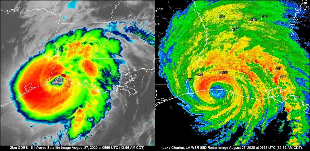
  • August 26-27, 2005: Katrina emerges into the Gulf of Mexico and undergoes rapid intensification, reaching Category 5 strength with sustained winds of 160 mph.
  • August 28, 2005: Katrina weakens slightly to a Category 3 hurricane but remains a formidable storm as it approaches the Gulf Coast.

Landfall and Immediate Aftermath:

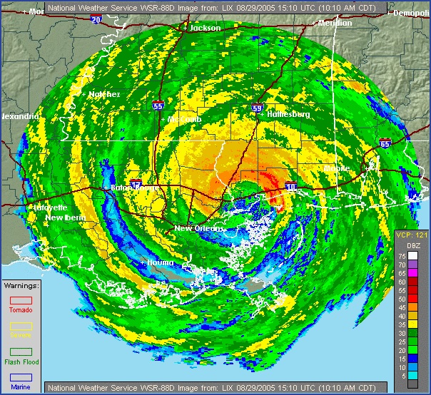
  • August 29, 2005: Hurricane Katrina makes landfall near Buras-Triumph, Louisiana, as a Category 3 hurricane with sustained winds of 125 mph. The storm surge, exceeding 20 feet in some areas, breaches levees in New Orleans, leading to catastrophic flooding.
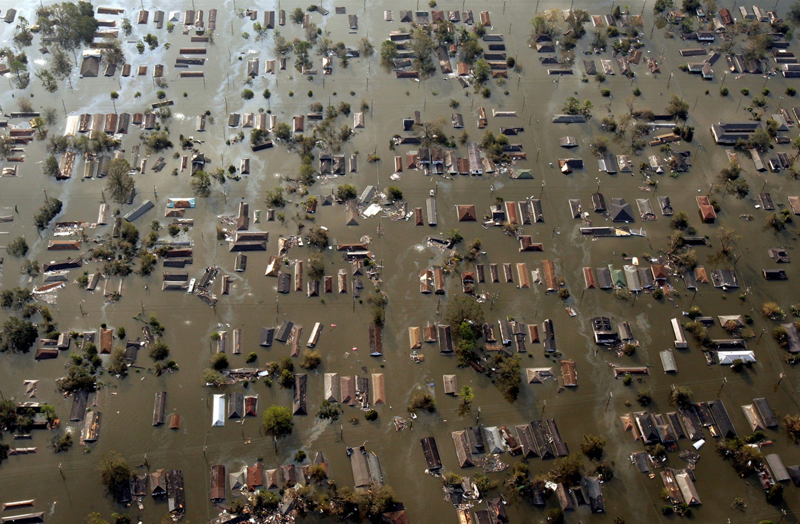
  • August 29-30, 2005: Floodwaters inundate New Orleans, submerging entire neighborhoods and stranding residents. The Superdome, serving as a shelter, becomes overcrowded and conditions deteriorate. Rescue efforts begin, but the scale of the disaster overwhelms response capabilities.

Unfolding Disaster and Response Efforts:

  • August 31 – September 4, 2005: The magnitude of the disaster becomes increasingly apparent as floodwaters remain stagnant and rescue efforts continue. The Lower Ninth Ward and other low-lying areas of New Orleans remain submerged, with residents trapped and desperate for help. Criticism mounts over the slow and inadequate response from federal, state, and local authorities.
  • September 5-10, 2005: Floodwaters begin to recede slowly, revealing the extent of the devastation. Search and rescue efforts transition to recovery operations, as debris removal and damage assessments begin. The death toll rises, and the displacement of hundreds of thousands of residents creates a humanitarian crisis.

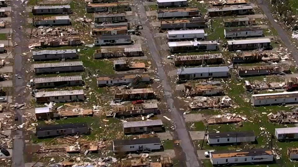
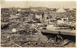
The consequences were immediate and devastating. Floodwaters surged through breaches in the levees, transforming streets into raging rivers and submerging entire neighborhoods. The iconic French Quarter, with its historic architecture and lively atmosphere, became an island amidst a sea of brown, polluted water. The Superdome, a massive stadium that had served as a shelter of last resort for thousands of evacuees, became a symbol of the city’s plight, its roof peeled back and its interior conditions deteriorating rapidly.

Across the city, tales of survival and heartbreak unfolded. Residents trapped in attics and on rooftops awaited rescue, desperate for any sign of help. Families were separated, loved ones lost, and homes destroyed. The Lower Ninth Ward, a predominantly African American neighborhood, suffered some of the worst flooding, its residents left stranded and forgotten for days. The stories that emerged from Katrina’s aftermath were a testament to the human spirit’s resilience in the face of unimaginable adversity.

Katrina’s impact extended far beyond New Orleans. Coastal communities across Mississippi, Alabama, and the Florida Panhandle were battered by the storm’s fury. In Biloxi, Mississippi, a once-thriving tourist destination, the storm surge swept away homes, businesses, and casinos, leaving behind a desolate landscape of debris and destruction. Gulfport, Mississippi, another coastal city, faced similar devastation, its harbor and waterfront areas obliterated by the storm’s power.

As Katrina moved inland, it weakened but continued to unleash torrential rains, leading to widespread flooding across the Southeast. Rivers and streams overflowed their banks, inundating homes and businesses and displacing thousands. The storm’s impact on infrastructure was equally devastating, with power outages affecting millions and transportation networks crippled. The economic toll of Katrina was staggering, estimated at over $100 billion, making it one of the costliest natural disasters in U.S. history.

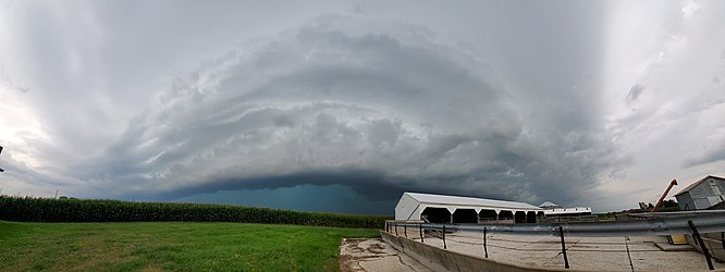
The meteorological factors that contributed to Katrina’s formation and intensification were a perfect storm of conditions. Warm waters in the Gulf of Mexico provided ample fuel for the storm’s growth, while low wind shear allowed it to maintain its structure and strengthen rapidly. A high-pressure system over the southeastern United States steered Katrina on a direct path towards the Gulf Coast, giving residents little time to prepare for the impending disaster.

Katrina’s legacy is complex and multifaceted. The storm exposed deep-seated social and economic inequalities, as marginalized communities disproportionately bore the brunt of the disaster. The failure of the levee system in New Orleans raised questions about infrastructure investment and disaster preparedness, prompting a national conversation about the nation’s vulnerability to extreme weather events. The storm’s aftermath was marked by a slow and often chaotic response, leading to criticism of government agencies at all levels and calls for reform.

Hurricane Katrina serves as a stark reminder of the destructive power of nature and the importance of preparedness, infrastructure investment, and social equity in mitigating the impact of such catastrophic events. The storm’s legacy continues to shape policy and planning, as communities strive to build resilience and ensure that the lessons learned from Katrina are not forgotten. The stories of survival, loss, and community spirit that emerged from the storm’s aftermath continue to inspire and remind us of the indomitable human spirit in the face of adversity.

The Midwest Derecho: An Unforgettable Tempest’s Trail of Wind Destruction (August 10, 2020)

The date August 10, 2020, is etched in the memories of millions across the Midwest, a day when the skies unleashed a tempest of unimaginable fury. A derecho, a powerful and expansive windstorm, ripped through the heartland, leaving a trail of devastation that stretched from South Dakota to Ohio. This wasn’t just a storm; it was a meteorological monster, its ferocity exceeding expectations and its impact leaving communities reeling in its wake.

The storm’s genesis lay in the atmospheric instability brewing over South Dakota and Nebraska. Thunderstorms erupted, fueled by a potent mix of warm, moist air and strong upper-level winds. These storms, initially isolated, began to coalesce into a line, forming a squall line, a telltale sign of a developing derecho. This line of storms, propelled by the jet stream, raced eastward at speeds exceeding 70 mph, evolving into a meteorological juggernaut.

Iowa found itself directly in the derecho’s path, bearing the brunt of its wrath. Wind gusts of up to 140 mph, equivalent to a Category 4 hurricane, tore through cities and towns. Cedar Rapids, a city of over 130,000, was particularly devastated. The winds, relentless and unforgiving, peeled roofs off buildings, tossed vehicles like rag dolls, and uprooted centuries-old trees. The city’s landscape was transformed into a scene of utter chaos, with debris littering the streets and power lines dangling precariously.

The derecho’s impact extended far beyond Cedar Rapids. Across Iowa, an estimated 14 million acres of cropland were damaged or destroyed, representing roughly a third of the state’s corn and soybean crops. The agricultural industry, the backbone of Iowa’s economy, suffered a staggering blow, with losses estimated in the billions of dollars. The storm’s fury also left millions without power, plunging homes and businesses into darkness and disrupting daily life for weeks.

In Cedar Rapids, Iowa, the derecho’s arrival was swift and brutal. At approximately 11:15 am, the sky turned an ominous green as the leading edge of the storm approached. Within minutes, the city was engulfed in a maelstrom of wind and rain. Residents huddled in basements and interior rooms as the deafening roar of the wind filled the air. Trees snapped like twigs, roofs were peeled off buildings, and debris flew through the air like missiles. One resident recounted the terrifying experience of watching a large tree crash through his living room window, narrowly missing him and his family.

The storm’s impact on rural communities was equally devastating. Farmers watched in disbelief as their corn and soybean fields, once lush and green, were flattened in a matter of minutes. Grain bins were crumpled like soda cans, and barns and outbuildings were reduced to piles of debris. One farmer, who had worked the land for over 50 years, described the scene as “total devastation,” his livelihood wiped away in an instant. The derecho’s impact on agriculture reverberated throughout the region, disrupting supply chains and causing food prices to rise.

As the derecho continued its eastward rampage, it maintained its intensity, leaving its mark on Illinois, Indiana, and Ohio. Chicago experienced wind gusts exceeding 90 mph, causing widespread power outages and bringing the city’s bustling transportation system to a standstill. In Indiana, the storm spawned several tornadoes, adding to the destruction. Even as the derecho weakened, it continued to produce damaging winds and heavy rain, extending its reach over 770 miles and impacting millions.

The meteorological intricacies that birthed and sustained this derecho were complex. A key factor was the presence of a strong upper-level jet stream, which provided the necessary wind shear to organize the thunderstorms into a line and propel them forward at breakneck speeds. Additionally, a pre-existing mesoscale convective system (MCS), a large cluster of thunderstorms, served as the derecho’s building block, providing a source of lift and moisture.

As the derecho matured, it developed a bow echo, a characteristic radar signature associated with destructive straight-line winds. The bow echo, shaped like an archer’s bow, indicated the presence of a powerful downdraft, which spread out upon reaching the ground, generating the hurricane-force winds that ravaged the Midwest. The combination of these factors created a perfect storm, a derecho of unprecedented power and scope.

Derechos have a long and destructive history in the United States, with several notable events leaving their mark on the nation’s memory. One of the most infamous derechos occurred on June 29, 2012, sweeping across the Mid-Atlantic region and causing widespread damage from Indiana to the East Coast. This derecho, known as the “Super Derecho” due to its exceptional intensity and scope, produced wind gusts exceeding 100 mph and left millions without power. The 2012 derecho traveled over 700 miles and caused an estimated $2.9 billion in damage, highlighting the destructive potential of these powerful windstorms.

Another significant derecho event occurred on May 8, 1995, impacting a large portion of the Midwest. This derecho, which originated in Kansas, traveled over 1,000 miles and produced wind gusts of up to 120 mph. The storm caused widespread damage to trees, power lines, and structures, leaving over 2 million people without power. The 1995 derecho was particularly notable for its long duration, lasting for over 12 hours, and its extensive path, which stretched from Kansas to the East Coast.

The Midwest derecho of 2020 stands out for several reasons. Its peak wind gusts of 140 mph were among the highest ever recorded for a derecho, rivaling the intensity of a major hurricane. The storm’s impact on agriculture was particularly severe, with millions of acres of crops damaged or destroyed, causing significant economic losses. Additionally, the derecho’s rapid intensification and relatively short warning time caught many off guard, underscoring the challenges of forecasting and preparing for these powerful windstorms. While derechos are not uncommon in the Midwest, the 2020 event served as a stark reminder of their destructive potential and the importance of remaining vigilant during severe weather events.

The Midwest derecho of 2020 stands as a stark reminder of the unpredictable and destructive nature of severe weather. Its impact extended far beyond the immediate damage to infrastructure and agriculture, leaving a lasting mark on the lives of millions. The storm exposed vulnerabilities in infrastructure and emergency response systems, prompting a reevaluation of preparedness measures and a call for increased investment in resilient infrastructure. As communities rebuild and recover, the memory of the derecho serves as a powerful motivator to strengthen defenses against future storms and ensure the safety and well-being of those who call the Midwest home.

Hurricane Laura’s Wrath: A Catastrophic Landfall in Louisiana (August 27, 2020)

The morning of August 27, 2020, dawned with a sense of foreboding for residents of southwestern Louisiana and southeastern Texas. Hurricane Laura, a formidable Category 4 storm with sustained winds of 150 mph, was churning in the Gulf of Mexico, its sights set on the coastline. This wasn’t just another storm; Laura was poised to become one of the most powerful hurricanes to ever strike the region, leaving an indelible mark on the landscape and its people.

Landfall occurred around 1 am near Cameron, Louisiana, a small community southwest of Lake Charles. The storm surge, a towering wall of water, surged ashore reaching heights of 15-20 feet in some areas. Homes were ripped from their foundations, businesses pulverized, and entire communities inundated with seawater. The relentless winds, equivalent to a high-end EF3 tornado, tore through structures, snapping trees and power lines like twigs. In Lake Charles, the Capital One Tower, a prominent 22-story building, sustained significant damage, its windows shattered and facade peeled away.

As Laura pushed inland, its fury continued unabated. Devastating wind damage extended far beyond the coast, reaching well into central Louisiana. The city of Alexandria, roughly 100 miles inland, experienced wind gusts of up to 97 mph, toppling trees and causing widespread power outages. Tragically, the storm claimed the lives of at least 30 people across Louisiana and Texas, with many succumbing to carbon monoxide poisoning from unsafe generator use during the widespread power outages.

The meteorological factors that fueled Laura’s intensification were a confluence of warm Gulf waters, low wind shear, and a favorable upper-level atmospheric pattern. Sea surface temperatures in the Gulf of Mexico were exceptionally warm, providing ample fuel for the storm’s growth. Additionally, wind shear, the change in wind speed and direction with height, which can disrupt hurricane development, was minimal. This allowed Laura to maintain its structure and strengthen rapidly. Finally, a strong high-pressure system over the central United States steered Laura on a direct path towards the Louisiana coastline, giving residents little time to prepare for the impending disaster.

Laura’s impact extended far beyond the immediate devastation of wind and surge. The storm triggered widespread flooding, as torrential rains inundated rivers and streams. Over 15 inches of rain fell in parts of Louisiana, leading to flash flooding and prolonged river flooding that lasted for days. Agricultural losses were extensive, with damage to crops and livestock estimated in the billions of dollars. The timber industry also suffered a significant blow, with millions of acres of forest flattened by Laura’s ferocious winds.

In the aftermath of the storm, communities across Louisiana and Texas began the long and arduous process of recovery. The Federal Emergency Management Agency (FEMA) and other organizations provided assistance with debris removal, temporary housing, and financial aid. However, the scars left by Hurricane Laura will take years, if not decades, to fully heal. The storm serves as a stark reminder of the destructive power of nature and the importance of preparedness in the face of such formidable forces.

The Tri-State Tornado: A Trail of Destruction Across Three States – March 18, 1925

The afternoon of March 18, 1925, etched itself into the annals of American history as the deadliest tornado event the nation has ever witnessed. A single, monstrous tornado tore through portions of Missouri, Illinois, and Indiana, leaving behind a 219-mile path of devastation. In its wake, the Tri-State Tornado, as it came to be known, claimed 695 lives, injured over 2,000 people, and caused catastrophic damage to homes, businesses, and the landscape itself. The roar of the tornado was said to be audible from miles away, described by survivors as sounding like a freight train or the continuous rumble of thunder.

Emerging in southeastern Missouri, the tornado first touched down around 1 p.m. near Ellington. Witnesses reported seeing a dark, swirling funnel cloud descend from the sky, growing in size and intensity as it moved across the countryside. The small community of Annapolis, Missouri was directly in its path, and within minutes, the town was reduced to rubble. Homes were obliterated, trees uprooted, and the local schoolhouse was completely destroyed with over 100 students inside. Miraculously, only one child lost their life due to the quick actions of the teachers who ushered the children into the basement just before the tornado struck. Sadly, 38 people lost their lives in Annapolis alone. Continuing its northeastward track, the tornado crossed the Mississippi River into southern Illinois, striking the towns of Gorham and Murphysboro. Murphysboro suffered the most significant loss of life with 234 fatalities. The business district was completely leveled, and the remains of the Murphysboro High School were scattered for miles.

As the tornado moved into Indiana, its path widened, reaching an astonishing 2.5 miles at its maximum width. The towns of Griffin and Owensville were heavily impacted, with countless homes and businesses leveled. In Griffin, a local church was destroyed while a service was in progress, resulting in the tragic loss of 69 lives. The Tri-State Tornado finally dissipated near Petersburg, Indiana, after a horrifying 3.5-hour rampage. In total, 19 communities were directly affected, with thousands of buildings destroyed and an estimated $17 million in property damage (equivalent to over $250 million today). The aftermath resembled a war zone, with debris strewn across the landscape and survivors left in shock and despair.

The meteorological conditions that spawned the Tri-State Tornado were a potent mix of atmospheric ingredients. A strong low-pressure system tracked across the central plains, dragging a warm front northward. To the south, warm, moist air surged from the Gulf of Mexico, while cold, dry air aloft created an unstable atmosphere. As the warm front collided with the colder air, powerful thunderstorms erupted, providing the energy needed for tornadic development.

The specific dynamics of the storm system, including wind shear (changes in wind speed and direction with height), contributed to the tornado’s longevity and intensity. The wind shear created a horizontal rolling motion in the atmosphere, which helped to concentrate and stretch the storm’s rotation, leading to the formation of a long-lasting and powerful tornado. Additionally, the relatively flat terrain of the region offered little resistance to the twister’s path, allowing it to maintain its strength over a longer distance.

The Tri-State Tornado remains a stark reminder of the destructive power of nature and the importance of severe weather preparedness. Its legacy has contributed to advancements in tornado research, forecasting, and warning systems, ultimately saving countless lives in the decades since this devastating event. The storm’s impact on the field of meteorology is undeniable, as it prompted further study of tornado formation and behavior, leading to improved understanding and prediction of these destructive forces.

One of the closest comparisons in terms of path length is the Great Natchez Tornado of 1840. This devastating tornado, which struck Natchez, Mississippi and surrounding areas, carved a path estimated to be between 150 and 200 miles long. However, due to limitations in record-keeping and population density at the time, the exact number of fatalities remains uncertain, with estimates ranging from 100 to 317 deaths.

Another notable tornado event was the 1974 Super Outbreak, which unleashed 148 tornadoes across 13 states in just 18 hours. This outbreak resulted in 330 fatalities and caused extensive damage. However, the Super Outbreak was characterized by numerous individual tornadoes, rather than a single, long-track event like the Tri-State Tornado.

The Destructive Dallas 2012 Hail Storm

On June 13, 2012, a single, isolated supercell thunderstorm pummeled the Dallas-Fort Worth (DFW) metroplex with golfball-sized hail, ranging from 1.75 inches (4.4 cm) to a staggering 4.25 inches (10.8 cm) in diameter – some exceeding the size of softballs. This event, classified as a PDS (Particularly Destructive Storm) by the National Weather Service (NWS), caused widespread devastation, with estimated costs reaching $900 million. This white paper delves into the meteorological setup, the extent of the damage, and the community’s response and recovery efforts.

2. Meteorological Conditions

An analysis by the NWS Fort Worth office revealed the following key factors:

  • High CAPE (Cape Accumulation of Potential Energy): The atmosphere held a significant amount of potential energy (CAPE) exceeding 3,000 J/kg, which fueled the storm’s intensity.
  • Strong Vertical Wind Shear: A strong change in wind speed and direction with increasing altitude created powerful updrafts within the storm, allowing hailstones to grow significantly.
  • Moist Mid-Levels: Abundant moisture present in the middle levels of the atmosphere provided ample water vapor for hailstone formation.

3. Extent of Damage

Data from various sources paints a grim picture:

  • Hailstone Size Distribution: According to insurance claim data, approximately 60% of the hail measured between 1.75-2.75 inches (4.4-7 cm), with 25% reaching 2.75-3.75 inches (7-9.5 cm), and the remaining 15% exceeding 3.75 inches (9.5 cm).
  • Property Damage: Over 150,000 residential and commercial property claims were filed, with an estimated 70,000 roofs punctured or destroyed.
  • Vehicle Damage: Insurance companies reported over 600,000 auto hail damage claims, with many vehicles deemed totaled.
  • Infrastructure Damage: Power outages affected over 200,000 residents, and numerous communication towers were damaged, disrupting phone and internet services.
  • Agricultural Damage: Over 50,000 acres of crops were destroyed, impacting local agriculture and raising food prices.

4. Economic Impact

The estimated economic cost of the storm was staggering:

  • $600 million: Property damage repairs and replacements.
  • $200 million: Vehicle repairs and replacements.
  • $50 million: Lost business revenue due to power outages and infrastructure disruptions.
  • $50 million: Infrastructure repair costs.
  • $100 million: Crop losses and agricultural impact.

These figures highlight the significant economic burden placed on individuals, businesses, and local governments.

5. Community Response and Recovery

The DFW community demonstrated remarkable resilience:

  • Emergency Response: Over 1,000 emergency responders worked tirelessly to ensure public safety, clear debris, and provide assistance to affected residents.
  • Volunteer Efforts: Thousands of volunteers emerged to help with cleanup efforts, organize donation drives, and provide emotional support.
  • Government Assistance: Local, state, and federal governments declared disaster zones, offering financial assistance to individuals and businesses for repairs.
  • Building Code Review: Building code revisions were initiated, focusing on strengthening roof structures and improving hail resistance for new construction.

Forecasting Tornadoes and Severe Storms With Modern Technology

Tornadoes, with their raw power and unpredictable nature, have long captivated and terrified people. While the science of forecasting these violent storms has progressed significantly, predicting their exact location and timing remains a complex challenge. However, thanks to advancements in technology, data analysis, and a deeper understanding of atmospheric dynamics, we can now decipher the skies with greater accuracy, providing crucial information to keep communities safe.

The Building Blocks of Severe Weather:

To understand tornado formation, we must first explore the ingredients that brew severe thunderstorms, their birthplace.

  • Instability: The atmosphere needs to be unstable, meaning the air near the ground is warmer and more humid than the air aloft. This temperature difference creates rising air parcels, the building blocks of thunderstorms.
  • Lift: Something needs to initiate the upward movement of air, such as a frontal boundary, a dryline, or even the heating of the ground on a sunny day.
  • Moisture: Ample moisture is necessary to fuel the development of clouds and precipitation within the thunderstorm.
  • Wind Shear: This refers to the change in wind speed and direction with height. Wind shear is crucial for creating rotation within the storm, a key ingredient for tornado formation.

Identifying the Threats:

Meteorologists rely on a variety of tools to identify and track potential severe weather:

  • Doppler Radar: This technology detects precipitation and wind movement within a storm. By analyzing the radar data, meteorologists can identify areas of rotation, known as mesocyclones, which are often precursors to tornadoes. Apps like Tornado Vision utilize radar data to provide users with a visual representation of storm rotation and the potential for tornado development.
  • Satellite Imagery: Satellites provide a broader perspective of weather systems, allowing meteorologists to track storm development, movement, and intensity.
  • Surface Observations: Data from weather stations on the ground, including temperature, humidity, wind speed, and barometric pressure, provide valuable insights into local atmospheric conditions.
  • Weather Models: Complex computer models simulate atmospheric processes to predict future weather conditions. While not perfect, these models have become increasingly sophisticated and provide valuable guidance to forecasters.

Advanced Tools for Enhanced Awareness:

Innovative apps like Predict Now, Hail No!, and Tornado Vision empower individuals with real-time data and storm tracking capabilities:

  • Predict Now: Provides users with comprehensive weather information, including forecasts, radar imagery, and severe weather alerts, allowing them to stay informed about potential threats in their area.
  • Hail No!: Utilizes a specialized hail detection algorithm to display hail locations and sizes in real-time, offering customizable alerts based on hail size and proximity to a user’s location. This app is particularly valuable for individuals in hail-prone areas or those who work outdoors.
  • Tornado Vision: Leverages the power of augmented reality to visualize potential tornadoes within storms. By pointing their phone at a storm, users can see an overlay of data, including the chance of a tornado, hail size, wind speed, and other critical storm characteristics. This innovative technology helps users make informed decisions about their safety during severe weather events.

The Importance of Preparedness:

While forecasting technology continues to improve, tornadoes can still strike with little warning. Preparedness is key to ensuring safety:

  • Stay Informed: Monitor weather forecasts and warnings from reliable sources.
  • Have a Plan: Develop a family emergency plan that includes a designated shelter location, communication protocols, and emergency supplies.
  • Practice Drills: Regularly practice tornado drills so everyone knows what to do and where to go in case of a tornado warning.

By understanding the science behind tornadoes and severe storms, utilizing advanced technology and tools like weather apps, and taking proactive steps toward preparedness, we can better navigate the unpredictable nature of these powerful events and protect ourselves and our communities.

The Joplin Tornado May 22, 2011

On a seemingly ordinary Sunday afternoon, May 22nd, 2011, the city of Joplin, Missouri, was forever altered. A monstrous EF-5 tornado, the deadliest single tornado recorded in the United States since 1947, tore through the heart of the city in a terrifying display of raw power. This 32-minute long leviathan left a path of destruction 6 miles long and over a mile wide, leaving behind a community grappling with unimaginable loss.

A Perfect Storm Unleashed:

The events leading up to the Joplin tornado were a meteorologist’s worst nightmare. An unusually warm and humid air mass surged northward from the Gulf of Mexico, colliding head-on with a cool, dry air mass descending from Canada. This dramatic clash created an incredibly unstable atmosphere, primed for violent storms. Adding fuel to the fire was strong wind shear, a rapid change in wind speed and direction with increasing altitude. These ingredients converged over Joplin, leading to the formation of a supercell thunderstorm – a behemoth capable of producing tornadoes of immense strength.

As the supercell approached Joplin, ominous signs became increasingly evident. A monstrous wall cloud, a low-lying, rotating cloud formation often a precursor to tornadoes, formed near the storm’s base. The atmosphere crackled with anticipation as the storm intensified. Within minutes, a monstrous funnel descended from the wall cloud, its swirling vortex growing larger and more menacing with each passing second.

Unrelenting Devastation: A City Reduced to Rubble

The Joplin tornado struck with unrelenting fury. At its peak, winds surpassed a staggering 200 miles per hour, exceeding the speed of a speeding bullet train. This unimaginable force leveled entire neighborhoods with horrifying ease. Homes were ripped from their foundations, businesses were reduced to piles of debris, and even the iconic Joplin High School wasn’t spared, collapsing under the storm’s relentless assault. Vehicles were tossed around like ragdolls, trees were uprooted and snapped in half, and power lines dangled precariously, sparking and spitting. The sheer power of the storm transformed Joplin into a landscape of utter devastation.

Beyond the Physical Toll: A Community in Mourning

The human cost of the Joplin tornado was nothing short of heartbreaking. The storm claimed the lives of 161 people, leaving countless families shattered. Over 1,150 individuals suffered injuries, ranging from minor cuts and bruises to life-altering trauma. The emotional toll on the community was immense, with survivors grappling with grief, loss, and the daunting reality of rebuilding their lives.

In the Rubble, Hope Emerges: A Community Rebuilds

In the face of unimaginable tragedy, the unwavering spirit of Joplin shone brightly. First responders from across the country rushed to the scene, risking their own lives to save others. Volunteers poured in by the thousands, offering a helping hand in the search and rescue efforts and providing much-needed emotional support to the grieving community. Amidst the devastation, a sense of unity and compassion emerged as the community came together to heal and rebuild.

The road to recovery was long and arduous. Thousands were left homeless, and the infrastructure of the city lay in ruins. The estimated cost of the damage reached a staggering $3 billion. However, Joplin refused to be broken. A monumental rebuilding effort began, with a focus on creating a more resilient city. Homes and businesses were reconstructed using stricter building codes designed to withstand future storms. The city center underwent a revitalization project, with a focus on creating green spaces and fostering a sense of community. Memorials were built to honor those lost, serving as permanent reminders of the tragedy and the unwavering spirit of Joplin.

Lessons Learned: A Legacy of Preparedness

The Joplin tornado served as a stark reminder of the destructive power of nature. It highlighted the importance of preparedness, early warning systems, and building codes designed to withstand powerful storms. In the aftermath of the disaster, Joplin implemented stricter building codes and invested heavily in public education programs on tornado safety. These proactive measures aimed to ensure that such a devastating event would never claim so many lives again.

The story of the Joplin tornado is a powerful testament to the human spirit. It is a tale of unimaginable loss, unwavering resilience, and the inspiring power of a community coming together in the face of tragedy. Joplin’s journey from devastation to recovery serves as a beacon of hope, reminding us that even in the darkest of times, the strength of the human spirit can prevail.

Chasing the Storm: How To Become a Storm Chaser

The allure of severe weather, with its raw power and captivating beauty, has drawn countless individuals to the world of storm chasing. The thrill of witnessing nature’s fury firsthand, capturing awe-inspiring images, and contributing to scientific understanding is undeniably enticing. However, venturing into the realm of storm chasing requires more than just a thirst for adventure; it demands meticulous preparation, a deep understanding of meteorology, and a profound respect for the inherent dangers involved.

Building Your Knowledge Base:

Before embarking on your storm chasing journey, a solid foundation in meteorology is crucial. Dive into the world of weather dynamics and familiarize yourself with the following:

  • Thunderstorm Formation: Understand the processes that lead to thunderstorm development, including atmospheric instability, lift mechanisms, and moisture sources.
  • Severe Weather Ingredients: Learn about the specific conditions that contribute to the formation of tornadoes, hail, damaging winds, and flash flooding.
  • Storm Structure Identification: Become adept at recognizing different types of clouds and thunderstorm structures, such as supercells, squall lines, and multicell clusters.
  • Radar Interpretation: Develop the ability to analyze radar data, including reflectivity, velocity, and storm relative motion, to track storm development and movement.
  • Weather Models: Familiarize yourself with various weather models and their limitations to gain insights into potential storm development and severity.

Essential Resources:

Expand your meteorological knowledge through various resources:

  • Online Courses & Tutorials: Numerous online platforms offer comprehensive meteorology courses and tutorials, ranging from basic weather principles to advanced storm analysis techniques.
  • Books & Field Guides: Invest in reputable books and field guides that cover storm structure identification, radar interpretation, and severe weather forecasting.
  • National Weather Service (NWS) Resources: The NWS website provides a wealth of information on severe weather, including safety tips, spotter training materials, and real-time weather data.

Equipping Yourself for the Chase:

The right equipment can make a significant difference in your storm chasing experience:

  • Vehicle: Choose a reliable vehicle with good fuel efficiency, ample storage space for equipment, and sturdy construction to handle rough terrain and potential hail damage.
  • GPS Navigation: Invest in a high-quality GPS system with real-time traffic updates and off-road capabilities to navigate unfamiliar areas and avoid hazards.
  • Mobile Weather Station: Consider a portable weather station to gather real-time data on temperature, humidity, wind speed, and barometric pressure, providing valuable insights into local atmospheric conditions.
  • Communication Equipment: Two-way radios or HAM radios are essential for staying connected with other chasers and monitoring weather updates from the NWS. Ensure you have the appropriate licenses and understand proper radio etiquette.
  • Cameras & Videography Equipment: Capture the awe-inspiring beauty of storms with high-quality cameras and video equipment. Invest in sturdy tripods and protective cases to safeguard your gear from the elements.

Safety First and Always:

Storm chasing inherently involves risk, and prioritizing safety is paramount:

  • Never Chase Alone: Always chase with a partner or team to ensure mutual support and assistance in case of emergencies.
  • Plan Escape Routes: Before embarking on a chase, meticulously plan escape routes and identify potential shelter locations in case of a sudden tornado threat or other hazards.
  • Monitor Weather Conditions Closely: Stay vigilant and continuously monitor weather updates from the NWS, radar data, and visual cues to assess storm development and potential threats.
  • Avoid Complacency: Even experienced chasers can fall victim to complacency. Never underestimate the power of a storm and be prepared to abandon a chase if conditions deteriorate or become too dangerous.
  • Respect Nature’s Power: Always maintain a healthy respect for the destructive forces of severe weather. Avoid placing yourself in unnecessary danger and prioritize your safety over capturing the perfect shot.

Ethical Chasing Practices:

Responsible storm chasing entails adhering to a strict code of ethics:

  • Respect Private Property: Never trespass on private land without permission, even in pursuit of a captivating storm structure.
  • Avoid Interference: Steer clear of emergency responders and avoid impeding traffic flow. Your presence should not hinder rescue efforts or create additional hazards.
  • Share Information Responsibly: Disseminate your observations and reports to the NWS and other chasers accurately and responsibly, avoiding exaggeration or sensationalism.
  • Promote Safety Awareness: Advocate for safe chasing practices and educate others about the potential dangers of severe weather.

Building Experience and Skill:

Start your storm chasing journey gradually and methodically:

  • Local Storms: Begin by chasing local storms in familiar territory to gain experience and confidence in identifying storm structures, navigating challenging road conditions, and making sound decisions under pressure.
  • Storm Chasing Tours: Consider joining organized storm chasing tours led by experienced professionals. These tours provide valuable learning opportunities and allow you to observe best practices firsthand.
  • Partnering with Experienced Chasers: Collaborate with seasoned storm chasers to learn from their expertise, gain insights into advanced chasing techniques, and expand your understanding of storm behavior.

Contributing to Science and Public Safety:

Storm chasers play a crucial role in advancing scientific understanding and improving public safety:

Citizen Science: Submit your storm reports and observations to the NWS through platforms like mPING or Spotter Network. This real-time data contributes to improving forecasts and warnings, potentially saving lives.

  • Collaboration with Researchers: Partner with meteorological researchers and universities to provide valuable data for storm analysis and modeling efforts, furthering our understanding of severe weather phenomena.
  • Educational Outreach: Share your experiences and knowledge with the public through presentations, workshops, or social media platforms. Promote awareness of severe weather preparedness and safety measures.

Beyond the Chase: Community and Advocacy

Storm chasing is not just about the adrenaline rush of witnessing nature’s power; it’s also about building a community and advocating for responsible practices:

  • Connect with Other Chasers: Join online forums, attend conferences, and participate in local storm spotter groups to connect with fellow enthusiasts, share experiences, and learn from one another.
  • Promote Ethical Chasing: Advocate for responsible chasing practices and encourage others to prioritize safety, ethics, and respect for private property and emergency responders.
  • Support Storm Research & Education: Contribute to organizations and initiatives that support storm research, public education, and severe weather preparedness efforts.

Becoming a successful storm chaser is a journey, not a destination. It requires dedication, continuous learning, and a healthy dose of respect for the power of nature. By prioritizing safety, ethics, and education, you can embark on a rewarding and thrilling adventure, chasing the storm while contributing to the greater good. As you embark on this exciting path, remember that the most valuable tools you possess are not just your equipment and knowledge but also your judgment, responsibility, and unwavering respect for the awe-inspiring forces of nature.

Storm Chasing Destinations Around the World: Exploring Nature’s Fury

Storm chasing is a thrilling and awe-inspiring pursuit that takes enthusiasts on a journey to witness the raw power of nature. From massive thunderstorms to tornadoes and hurricanes, storm chasers seek out these dramatic weather phenomena in various locations around the globe. In this article, we’ll delve deeper into some of the top storm chasing destinations, each offering unique experiences and challenges for adventurous souls.

1. The Great Plains, United States: A Hotbed for Tornado Activity

Encompassing parts of Texas, Oklahoma, Kansas, Nebraska, South Dakota, and Iowa, the Great Plains region in the central United States is a legendary storm chasing ground. This region, infamous for its high frequency of tornadoes during spring and early summer months, attracts professionals and enthusiasts alike. The flat terrain of the Great Plains, coupled with clash zones between warm, moist air from the Gulf of Mexico and cooler air from the Rockies, creates ideal conditions for tornado formation. Witnessing a supercell thunderstorm erupt into a tornado against the vast, open canvas of the Great Plains is an unforgettable experience.

  • Annual Average: Approximately 1,200 tornadoes
  • Most Deadly/Destructive: The Tri-State Tornado of 1925, which ripped through Missouri, Illinois, and Indiana, remains the deadliest tornado in US history, with an estimated 695 fatalities.

2. Arid Fury: Storm Chasing in the Australian Outback

For those seeking a unique storm chasing adventure, Australia’s vast and remote Outback offers a rugged environment. During the Australian summer, regions like Queensland, the Northern Territory, and parts of Western Australia witness a range of severe weather, including thunderstorms, cyclones, and dust storms. The stark contrast of red desert landscapes against dramatic storm clouds creates breathtaking scenes for photographers and adventurers alike. The Outback’s isolation and unpredictable weather add an extra element of challenge and excitement to storm chasing expeditions. Imagine capturing a colossal dust storm engulfing the horizon, a sight unique to the Australian Outback.

  • Annual Average: Around 100 tornadoes, with a concentration in the southeastern states.
  • Most Deadly/Destructive: The 1970 Bulahdelah tornado remains one of Australia’s most destructive tornadoes, causing significant damage and several fatalities.

3. North American Expansion: Chasing Storms in Canada’s Prairies

Canada’s prairie provinces, particularly Alberta, Saskatchewan, and Manitoba, form a northern extension of the storm chasing territory. While less frequent than in the southern United States, tornadoes do occur here, alongside powerful supercell thunderstorms and impressive hailstorms. Chasing storms in Canada presents a different perspective due to the unique weather patterns influenced by the Rocky Mountains and the Arctic. The vast Canadian prairies, dotted with lakes and farmland, offer a picturesque backdrop for capturing the drama of a supercell thunderstorm.

  • Annual Average: Around 62 tornadoes, primarily in the southern Prairie provinces and Ontario.
  • Most Deadly/Destructive: The Regina Cyclone of 1912 devastated the city of Regina, Saskatchewan, claiming 28 lives and causing extensive damage.

4. Southern Hemisphere Spectacle: Argentina’s High Plains

Spring and summer in Argentina transform the Pampas region, also known as the High Plains, into a storm chaser’s paradise. Here, rapid development of thunderstorms occurs due to warm, moist air from the Atlantic colliding with cool air from the Andes Mountains. The result? Spectacular lightning displays and occasional severe weather events that draw storm enthusiasts from across South America. The vast grasslands and dramatic skies of Argentina’s High Plains provide a visually captivating backdrop for chasing storms. Imagine witnessing a mesmerizing electrical storm illuminate the endless expanse of the Pampas.

Annual Average: Argentina experiences a moderate number of tornadoes, particularly in the Pampas region, with estimates ranging from 20 to 60 tornadoes per year. The spring and summer months (October-March) are the peak season for tornado activity.

Most Deadly/Destructive: The 1973 San Justo Tornado: This powerful tornado, estimated to be an F4 or F5, tore through the town of San Justo in the Buenos Aires Province on January 10, 1973. The tornado caused significant casualties, with estimates ranging from 63 to 120 fatalities, and left a path of destruction through the town, leveling homes and businesses. This event remains one of the deadliest tornado disasters in Argentina’s history and serves as a reminder of the potential for destructive tornadoes in the region.

5. European Encounters: Unveiling the Power of European Storms

While Europe may not experience tornadoes with the same frequency as the United States, it has its fair share of dramatic weather. Countries like the United Kingdom, France, and Germany witness intense thunderstorms and supercells during specific times of the year. The diverse landscapes of Europe, from rolling hills to scenic coastlines, offer a unique opportunity to capture the fury of nature in various settings. Imagine capturing electrifying lightning shows illuminating iconic landmarks or dramatic cloud formations gathering over picturesque countrysides.

  • Annual Average: Europe experiences a variable number of tornadoes, with an estimated average of around 300-400 tornadoes per year across the continent.
  • Most Deadly/Destructive: The 1984 Ivanovo tornado outbreak in Russia resulted in significant destruction and loss of life.

6. Monsoon Majesty: Unveiling the Power of India’s Seasonal Storms

From June to September, India’s monsoon season blankets the country in heavy rainfall, dramatic thunderstorms, and occasional cyclones. Regions on the western coast, including Goa and Kerala, as well as northeastern states like Assam, witness some of the most spectacular weather events, attracting both local and international storm chasers seeking the intense displays of the monsoon. The monsoon’s impact on India’s diverse landscapes, from lush forests to coastal plains, creates a dynamic and visually rich environment for storm chasing and photography. Imagine witnessing a powerful monsoon storm unleash its fury over the lush jungles of India.

Annual Average: While comprehensive data is limited due to underreporting, estimates suggest India experiences around 100-200 tornadoes annually. These tornadoes are often associated with the monsoon season (April-June) and post-monsoon season (September-November).

Most Deadly/Destructive: The 1998 Andhra Pradesh Tornado: This devastating tornado, estimated to be an F4 on the Fujita scale, struck the East Godavari district of Andhra Pradesh in May 1998. It resulted in over 100 fatalities and caused widespread destruction to homes, infrastructure, and crops. The tornado’s impact highlighted the vulnerability of rural communities in India to severe weather events and the need for improved disaster preparedness and response systems.